Here are details of some walks around Thornton, and beyond, including all of Bradford Council’s “self-guided” walks, and walks to local places of interest like Goit Stock waterfalls and Ogden Water. There’s also 2 sets of walks further afield, around Wycoller, and to Lumb Hole waterfalls, north of Hebden Bridge. For known walking groups scroll down to the end of this page.
Click on the underlined green words for details of each walk
Bradford Council’s Map of Paths, an online map of public Rights of Way can be found here. An online map of public rights of way to help you plan a walking or riding route. This is a digitised interpretation of the Definitive Map and other records. This is not the legal record and so must not be relied upon for legal purposes. It is a working copy and is updated or amended from time to time, therefore rights of way shown on it may occasionally change slightly. When you click on the link to the map, please read the subsequent information carefully: it starts with guidance regarding using public rights of way during the Coronavirus (Covid-19) pandemic, and if you scroll down from this you will find further information regarding the online map. See also the Council’s Footpaths and Rights of Way page. (Updated 14 August 2021)
NOTE From 8am on 11 April to 6pm on 10 October 2024 Footpath 34 will be closed., because of building works. Footpath 34 runs from Thornton Road to Squirrel from west of the Fireclay Business Park to Squirrel House Farm, and on to the road which Bradford Council call Cragg Lane. (I call Squirrel Lane)
The Brontë Way passes through Thornton coming up via Corn Mill Lane off Cockin Lane near its junction with Chat Hill and Low Lane. It comes up to the lower part of Coach Lane, turns left along Thornton Road, past the Brontë Bell Chapel churchyard, the remains of the Chapel where the Reverend Patrick Brontë was the priest, then right up the footpath between the west end of St James’ Church and the Vicarage, then left on to Brontë Old Road. Continue along to the end of Brontë Old Road, and straight forward onto Market Street, past the Brontë birthplace on the right (number 62-64), then to the end of Market Street. The Black Horse is at the bottom of and on the left hand side of West Lane. The Brontë Way continues up West Lane to its junction with the steep James Street. Cross the road and go along Reservoir view to the end where there’s a stile. Go through this and the footpath continues across the fields and the top of the cemetery. (Updated12 July 2023)
A circular walk from St. James Church, 4¾ miles / 7.6 Km Through the village, along Reservoir View to the cemetery, down Close Head Lane, across to Squirrel and Deep Lane, on to West Scholes, and back over the fields to Headley Lane and back via field footpaths to St. James Church. Compiled by Bradford Council’s Countryside and Rights of Way section, . (Updated 23 April 2024)
A circular walk to the north of Thornton starting at the junction of Market Street and West Lane. 5 miles / 8 Km Compiled by Bradford Council’s Countryside and Rights of Way section. (Updated 14 August, 2018)
From Coffin End via Lower Kipping Lane, over Pinch Beck to Headley Lane, back across the viaduct to Market Street and Thornton Road. An annotated and interesting walk provided by the Discovering Britain organisation. (Updated 11 August 2018)
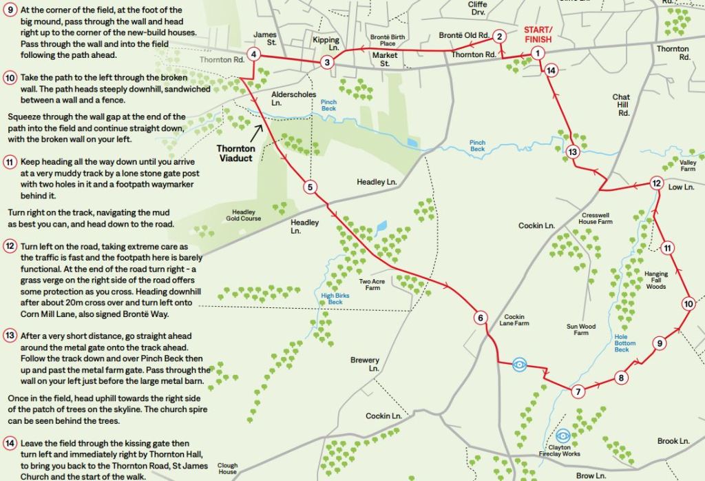
Thornton Viaduct Circular A new walk for “Bradford on Foot, art of Bradford Capital of Culture 2025. For full instructions click / press on the green words above. See illustration. (I shall keep a copy on my PC in case it vanishes after the C of C 2025.) (Uploaded 11 July 2025)

Thornton Village Trail walks Two walks from a leaflet called “Thornton Village Trail”, comprising one starting opposite St. James Church, and returning there, a shorter walk than the circular walk given above; and the other from the Brontë birthplace to Upper Headley and Malt Kiln Lane, returning by Gill Lane and the Alderscholes area. Press / click on the Green underlined heading for instructions and maps. The walks could also be combined. (Updated 26 August 2024)
Five Beck Circular Walk. A walk of 5.6 miles / 9 Km, compiled by the Friends of Bradford’s Becks, starting and finishing on Leaventhorpe Lane, and taking in Clayton Beck, Middle Brook, Bull Green Beck, Chellow Dene Beck and Pitty Beck. (Updated 11 August, 2018)
The Source of Pitty Beck circular walk 2.8 miles / 4.5 Km Compiled by the Friends of Bradford’s Becks. Starting and finishing on Long Lane, Allerton. An alternative starting point could be on Egypt Road, but the description of the walk is from and to Long Lane. (Updated 11 August 2018)
Pinch Beck, High Birks Beck and Hole Bottom Beck Length: 6km / 3.7 miles. Terrain: quite strenuous in places, with three steep climbs. Some road walking. Starting point: path to Great Northern Trail next to Thornton Primary School, Thornton Road BD13 3NN Compiled by the Friends of Bradford’s Becks, who have on their website more walks in other nearby areas, see below under Other Walks. The Friends of Bradford’s Becks also have a Facebook page (Updated 12 June 2021)

The Great Northern Railway Trail is part of Sustrans national walking and cycling route 69, which aims to link Morecambe with Grimsby. Sustrans have written a Guide to the two parts of the Trail which are in use in West Yorkshire. It is downloadable. There is a very good video produced by Forgotten Relics Rambles: Thornton to Queensbury, which covers the whole of the local part of the Great Northern Trail from Thornton to Queensbury. (Updated 25 June 2024)
The Brontë Walks are walks conceived by local author Michael Stewart. The walks are described on his website. Scroll down the page which you come to; the link he gives to “the official website” doesn’t work, (tried on 16 July 2023). Copies of the walks are available to buy from Plenty in South Square. The Brontë Stones, with locations are shown on this website. (Updated 6 August 2024)
A 2½ mile walk compiled by Rosie and given in full on her blog: Busy Mum Lifestyle Start at the Brontë birthplace on Market Street, up to the cemetery on Thornton Road, walking back towards the village on Woodsley Fold, onto the Great Northern Trail, through School Wood, towards the school, over the viaduct to Headley, turn left down Headley Lane, continue up Green Lane to Market Street and back toward the Brontë birthplace. (Updated 22 January 2021)
The Bradford Branch of the Ramblers Association also hold free guided walks. Those in or near to Thornton are listed in the Diary of events section of this website, and all walks are shown on the Ramblers’ website.
Bradford Fair Trade Way walks, include two from or two Thornton. Walk 8 is from Haworth to Thornton, and Walk 9 is from Thornton to Bradford
Walks further afield
Chellow Dene reservoirs area
Chellow Dene Beck and Reservoirs (3.91miles)
Chellow Dene reservoirs 2.5 mile (4Km). A circular walk around Chellow Dene reservoirs and adjoining countryside.
Denholme and Doe Park Reservoir
Around Doe Park Reservoir, Denhome A Bradford Council walk, 3miles / 4.8 km. Note bus numbers has changed to the 67, and the bus running between Halifax and Keighley is the 502. (updated 24 April, 2023)
Goit Stock waterfall

- Goit Stock waterfall (from Harden), short waterfall walk, description by Yorkshiretots.com
- A ramble on the Harden Valley, a 10.7 mile well documented difficult walk by Bingley Walkers
- Goit Stock waterfall by Get Lost blog
Ogden Reservoir
- Ogden Reservoir 1.2 miles (2Km). Easy walk, about 1 hour, around Ogden Reservoir. Walk designed by Yorkshire Water (owners of Ogden Water).
- Ogden Water Walking Route “Enjoy fabulous views of the Pennine hills at this country park near Halifax. There is a super waterside path around the 34 acre reservoir while there are other paths leading into the surrounding moors. It’s a very picturesque place with nice views across the water to the surrounding woodland and moors.” (Updated 17 September 2023)
- Ogden and Thornton Moor Reservoirs length 6.73 miles (10.83Km); surface: Moderate; difficulty: Medium; total ascent: 780 feet; total descent 777 feet; maximum elevation: 1399 feet; minimum elevation: 985 feet. Scenic walk on track and open moorland starting and finishing at Ogden water country park.
- Ogden Water Walks, produced by Ogden Water Nature Reserve.
Other areas
- Bradford to Shipley along Bradford Beck. Length: 6km. Terrain: a climb at the beginning and one in the middle, otherwise easy going. Starting point: the beginning of Bolton Road by the flight of stone steps near the entrance to Bradford Cathedral BD1 4DA. Note: in 2018, the route is partly blocked by construction. The amended guide explains how to avoid these and complete the walk. Download the guide: Bradford to Shipley along B Beck Walk Guide, and Bradford to Shipley amended Walk devised by the Bradford Becks group
- Gill Beck and Spring Wood. Length: 4.7km, on the edge of Baildon. Terrain: tracks and paths, an optional stream crossing on rough stepping stones. Listen to the Beck as you walk alongside through beech and oak woods past several springs. Download the guide: Gill Beck circular Walk devised by the Bradford Becks group
- Morton Beck has lots of mill ponds: Length: 5.4m Crossflatts and East Morton area. Starting Point: Morton Lane, Crossflatts. Terrain: paths, a little road walking on quiet roads. Outbound entirely uphill! Two shallow streams to cross on stones. Babbling brook, millponds and reservoirs, quaint East Morton, mysterious ruins. Download the guide: Morton Beck walk Walk devised by the Bradford Becks group
- Northcliffe Dike and Red Beck Walk. Length: 4km. Terrain: easy paths with some road walking where care is needed. One short climb. Starting point: car park in Cliff Wood Avenue, off Bradford Road BD18 3DD. This walk gives views across the Aire Valley and takes you through old deciduous woodland where you can criss-cross the streams via small bridges. Download the guide to Northcliffe Dike and Red Beck Walk Guide Walk devised by the Bradford Becks group
- The Plaques Trail. Length: 0.8km through Bradford’s city centre. Starting point: alongside the former Odeon Cinema in Thornton Road. The plaques mark the route of Bradford Beck beneath your feet as you find carved plaques in the pavement which bear the direction of flow and two lines of a wonderfully evocative poem about the beck. Download the guide: The Plaques Trail Walk Guide Walk devised by the Bradford Becks group
- Royd Hall Beck and Judy Woods. Length 5.2km, between Woodside/Buttershaw and Wyke. Starting point: Meadway, BD6 2SP. Terrain: Good paths through woodland. A delightful walk through ancient woodland accompanied by the sound of water. Download the guide: Royd Hall Beck and Judy Woods. Walk devised by the Bradford Becks group
In addition Bradford Council’s Recreation Department has compiled a series of self-guided walks. These can be seen as follows:
Outside Bradford Metropolitan District
Lumb Hole Falls, in Wadsworth, 3 miles north of Hebden Bridge, Calderdale.
- Hidden Yorkshire: How To Find Lumb Hole Falls: a route from Midgehole car park, 1.7miles.
- Lumb Hole Falls (Best walking routes and parking spots) Shorter walks, 0.5mile to 3.4miles. (The B3 bus from Keighley to Hebden Bridge goes along the A6033, with stops around Pecket Well.)
- Ultimate Lumb Hole Falls Guide (How To Find The Hebden Bridge Waterfall). Scroll down to Lumb Hole Falls Walk Route Info (Distance: 15km (9 miles); Time: 3 hour 30 minutes – 4 hours; Starting Point: Hebden Bridge, HX7 6JE, then a step by step guide to the walk, with illustrations, is given.
Wycoller, near Laneshawbridge.
- Walk around Wycoller Country Park
- Wycoller Country Park – GPS Cycle and Walking Routes
- Wycoller, Brinks End Moor, Boulsworth Hill, Lad Law and Trawden
- (The) Wycoller Panoptican Walk
Known walking Groups
In Thornton there is 1 group who walk. See “Walking for all” in Groups and events by type.
Our neighbouring village of Clayton also has a walking group called the Clayton Footpaths Group.
In the Bradford area there are 3 main groups: The Bradford Ramblers who are not affiliated to the national Ramblers Association, and the Bradford group of the national Ramblers Association , and the Bradford Walking CHA
The is also the Midweek Wayfarers Group, a Yorkshire walking group. Their website also includes some Suggested walks with routes and or maps.
The Recreation section of Bradford Council organise Guided Walks all year round.
(Updated 12 August 2025 to include a link to the Bradford CHA walking group)
