For other places click / press on the appropriate button
East View (1) Shown on the 1891 map. The East View off Back Lane, near to what is now Valentine Court.
East view (2) East view near South View on Upper Heights Road.
Eddie’s Corner, Kipping Lane. Next to what is now Brontë Nook. Some time ago it was overgrown, but restored. Click on the green link for further details. In the Conservation Area. (Reviewed 9 September 2022)
Edge House Farm and road from Hill Top Shown on the 1852 map. The land around it was sold by Abe Shaw to Bradford Corporation for allotments, though now Bradford Council looks upon the fields as a potential housing site.
Egypt Shown on the 1852 map. 8-12 Egypt Road are Listed buildings, dating from the early 19th century An area and dwellings at the start of Dean Lane.
© Copyright Christine Johnstone and licensed for reuse under this Creative Commons Licence.
Egypt Methodist Chapel Likely to have been built in 1852. Shown on the 1891 map. The Chapel was just on the Allerton side of Pitty Beck, while the cottages are on the Thornton civil parish side. Close to and south-east of the back to back dwellings at Egypt. By 1921 was a United Methodist Chapel. Baptisms there ceased in 1965. The last service was at 6pm on Sunday October 3rd, 1965 and the chapel was demolished shortly afterwards. The Memorial Window to some men who died in the 1st World War is shown in the War Memorials section.
Egypt Quarry Shown on the 1852 map. A sandstone quarry to the west of Egypt.
Egypt Road was not named until the 1908 map.
Elizabeth Brontë Mews, see Gleeson development. (Updated 12 July 2023)
Ellingham Court, dates from the year 2000, though the original buildings formed Thornton Church 1st School which was closed down when schools were reorganised from 3 tiers to 2 tiers. The school building was then sold and converted into dwellings. At the top of the un-named road, also known as School Street, off Market Street, near to the juntion with Havelock Square. (Updated 26 November 2023)
Emily Brontë Road, see Gleeson development. (updated 12 July 2023)
Enderley Road Joins the south end of Priestley Street with Friendly Street.
Evelyn Terrace, Mountain, in that part of Mountain which was in the Thornton civil parish until the year 2004. On the main road, Brighouse and Denholme Road. (Updated 26 November 2023)
Excelsior Works, textile mill formerly named Ash Tree Shed. Newspaper advertisements show that the name changed at some time between 1901 and 1904. See Ash Tree Shed for its subsequent history. (Updated 14 June 2023)
Fall Bottom On the 1852 O.S map and the 1849 Tithe Award map: Dwellings on the north side of the junction of Low Lane with Cocking Lane, now in Clayton Ward, Thorntree Farm with integrated barn. Listed building dating from the early 19th century. The term “Fall Bottom” does not show on maps after 1891.

Far Malt Kiln On the 1852 map. A building to the east of Malt Kiln on Malt Kiln Lane. Now known as Far Malt Kiln Farm.
Farriers End A converted barn near to Upper Headley Hall.
Fawthrop Hotel, in the 1871 Census, at 4 Market Street. In the 1861 Census it is called Fawthrop Buildings, and in the 1849 Tithe Map its 4 dwellings owned by Widow Fawthrope. The Bradford Observer reported on the meeting of the Thornton Local Board which had received an application to erect stables at the Fawthrop Hotel beerhouse. It was resolved that the place should be inspected. In the 1881 Census it was still the Fawthrop Hotel. In the 1891 and 1901 censuses the occupier was a Licensed victualler but no name of the pub is given. In the 1911 Census the name of the pub was the Springfield. Newspaper advertisements show that it was still Fawthrop’s Hotel in November 1893, when it was for sale. Oddly newspaper articles show it to be the Springfield Hotel from February 1892, so more research needed. There was another hotel close to the Springfield called the Union, and the Fawthrop may have been the former name of the Union. More research needed. (updated 27 April 2023)
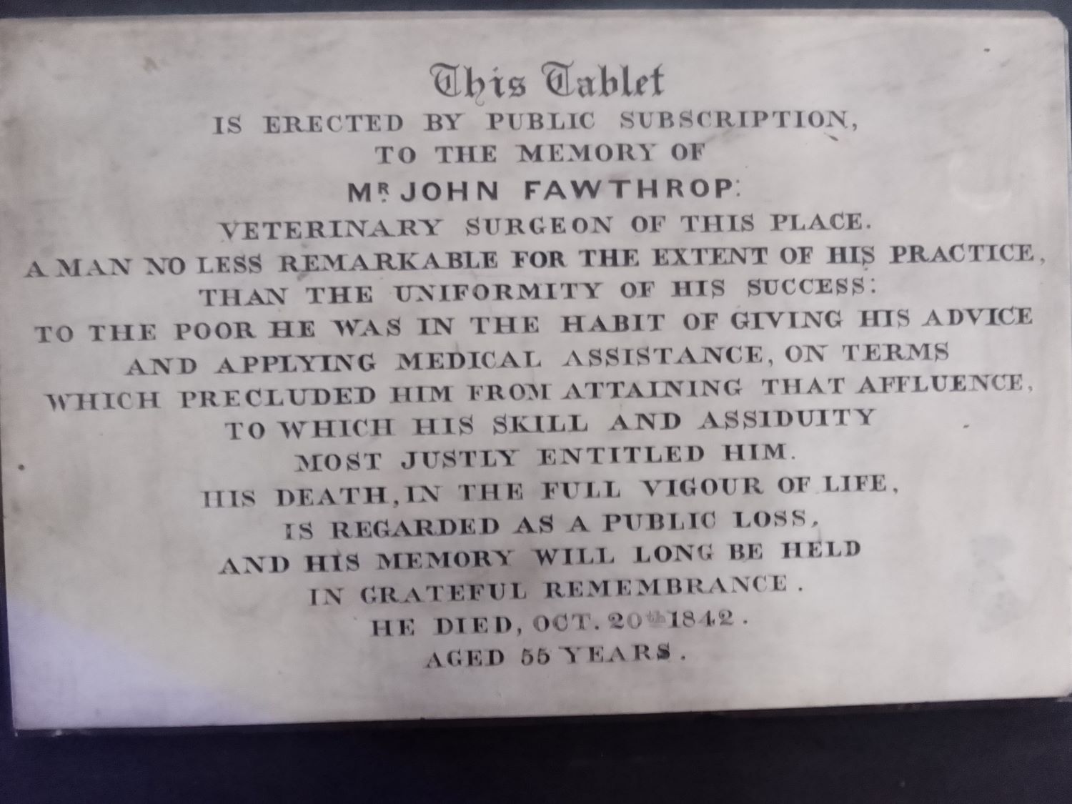
Fawthrop, John, born about 1787, died 1842. For further details of this Thornton resident, likened to the good Doctors of Whitworth, and praised on a tablet erected in the St. James “Bell” Chapel, in 1843. “click” here, or on his name at the start of this paragraph. (Updated 11 September 2023)
Field Court On the 1891 map, unnamed. Three dwellings as now.
Field names: Each field had a name so that it could be readily identified. The 1849 Thornton Tithe award has details of over 2,000 field names in our area. They can be viewed online at West Yorkshire Archives Office website, from the Tithe map and award. The transcription of the field names can be downloaded. Examples of field names are: Shrog, Three Nook, Jenny Royd, Kindle Flats, Balmforth Ing, Well Ing, Dumpling Ing, Two Days Work, and many many more.
Filter House On the 1933 map. (Bradford Corporation Water Works), on the route to the Bottom of the Row, from Thornton Road, where there is in 2022 a bus turning circle.
Firth Street The first Census to include Firth Street is that of 1871. A reference to Firth Street is found in a report of discussion at the Thornton Board of Health, regarding the diversion of a footpath starting at Firth Street, in the Bradford Observer of 18 January 1866. A street, mainly of back-to-backs leading from Thornton Road, across George Street northwards. (Updated 20 June 2023)
Foster Avenue On the 1933 map. A cul-de-sac from the Thornton Road end of Churchill Road. Part of the original Thornton council estate.
Fountain Street In the 1881 Cenus, but maps show building on the street before then. Fountain Street in the news:
- 1874, June 25 A advertisement in the Bradford Observer: “Wanted, General Servant, who understands plain cooking. Apply A. Mitchell, Printer, Fountain Street, Thornton, near Bradford.“
- 1874, October 12. A report of the Local Board meeting states that plans of a cottage, proposed to be built by Mr. John Ambler, at the back of Fountain Street were approved subject to the Board’s Surveyor approving the site on examination.”
- 1886, May 18, an advertisement in the Bradford Daily Telegraph “Butcher’s Old established business, good shop and house to let. Apply Fountain Street, Thornton, near Bradford.“
- 1889, June 1, a report of the outcome of an auction for two properties in Fountain Street. For a house and shop in the occupation of Mr. F. Harper, stationer, bidding started at £100, and it was sold for £250. For a house and shop adjoining bidding started at £100 and it was sold for £249.
- 1892, December 10. The Bristol Times reported that Frederick Harper, stationer and newsagent of Fountain Street, Thornton, near Bradford, had died.
- 1893, January 20. The Bradford Daily Telegraph reported of action in the Bradford Bankruptcy Court, including that of Fred Harper, newsagent and stationer. It was reorted that 12 years previously he had been a quarryman, but with a pound or two of capital he started as a newsagent. For a time he was also an insurance agent, and also became an agent of the telephone company, but “he could not make headway, and pressure on the part of the creditors caused him to file his petition”.
- 1895, June 4. The Bradford Daily Telegraph reported on a sale of a property which had frontages both on Market Street and Fountain Street, in the occupation of Mr. W. Sykes, a draper, and was formerly a branch of the Bradford Old Bank, and post office business also used to be transacted there. Bidding started at £00 and was bought by Mr. F. Pearson for £720.
- 1897, October 2. An advertisement in thr Bradford Observer read “Shaving and Hairdressing. MAN Wanted, to commence immediately. Must be good shaver, steady and reliable. Apply personally to Mitchell 12 Fountain Street, Thornton.”
- 1908, June 26. A lengthy report in the Bradford Daily Telegraph told of an Open Air Meeting at the top of Fountain Street, arranged and attended by Thornton Liberal Association in connection with Keighley Parliamentary Constituency, “and was purely propaganda work“.
- 1910, January 29. An advertisement in the Bradford Daily Telegraph was “Painter and Paperhanger’s stock and fixture to sell. Nearly new. Ill-health cause. J. Hartley, Fountain Street, Thornton.”
- 1912, June 5. In the Bradford Daily Telegraph, an advertisement offered to let 2 Fountain Street, Thornton, suitable for “hairdresser, shoemaker, plumber, paperhanger“.
- 1913, October 18. A report in the Yorkshire Post and Leeds Intelligencer, stated that 2 cottages, numbers 3 and 5 Fountain Street, Thornton, with a gross annual rental of £17 and 11 shillings, were sold for £180.
- 1921, December 13. An advert in the Yorkshire Post and Leeds Intelligencer, for the sale of a “Maxwell car, 5-seater, electric lights, self-starter, perfect condition; £120; must sell. Townend, 4 Fountain Street, Thornton, Bradford. Tele 83 Thornton.“
- 1935, July 5. The Yorkshire Post and Yorkshire Evening Post reported on a case at Bradford City Court when John Matthew Spence (aged 30), a turner. of Fountain Street was accused on coining, the manufacture and use of counterfeit half crowns, possession of moulds and having in his possessions which he knew to be counterfeit. The coins were described by the Prosecution as “the best seen for a long time.” Mr. Spence was committed for trail and the next Leeds Assizes. The Leeds Mercury of 11 July 1935 reports that Mr. Spence was sentenced to 9 months imprisonment.
- 1936, November 5. The Bradford Observer had a notice of a sale, “to close a trust” of “2 and 4 Fountain Street, together with the out-conveniences thereto belonging, in the respective occupation of Mr. F. Emmott and the G.P.O.“
- To be continued (Updated 17 February 2025)
Friendly Inn was on the site of Thornton Conservative Club prior to 1909. In the 1871 Census the Innkeeper was Anthony Craven, who was aged 32. (Updated 24 April 2023)
Friendly Street On the 1908 map built and named. Numbers 1-19, and 2-10 are Grade II Listed buildings together with 383 Thornton Road, dating from the early 19th century.
Garden Top (and Top of the Garden) appear in the 1841 Census. It’s not obvious where they were, but probably in the vicinity of Sap Gate Lane, then called Sack Pit Lane. (Updated 7 May 2023)
Gate End in the 1851 census, thought to be near Mountain in that part of Thornton which transferred to Queensbury civil parish in the year 2004. 3 families, whose names do not appear in the 1849 Tithe award. Occupations include both hand loom and power loom weavers, woolcombers and a spinner, plus coal miners and a pit boy. (updated 17 August 2023)
George Street is referred to in a land sale notice in the Bradford Observer of 11 January 1866. “Lots 17, 18, 19, 20, and 21. Five plots of Building Land, fronting to an intended street, to be called George Street…Four of these lots each have the advantage of two frontages.” Lots 22, 23. 24, 25, 26, and 27, were 6 plots , “having south frontages to George Street aforesaid, forming eligible sites for the erection of first-class cottage dwellings….” A street leading from James Street to Henry Street. Number 1 was formerly a police station. The Club having a side abutting Firth Street was originally built as Thornton Liberal Club, which had a memorial to members killed in the First World War. The memorial has been lost. (Updated 20 June 2023)
Gill Lane Named on the 1852 map. Also shown on the 1849 Tithe Award map. A footpath lane between Malt Kiln Lane and Alderscholes Lane, one part going northwards through Brow Bottom, the other going north-eastwards coming out near Pinch Beck. The photo is of Gill Lane at the Malt Kiln Lane end.
Gleeson development, also known as Squirrel Fold. Gleesons are currently (mid 2023) building 160 new houses on the west side of Thornton, off Thornton Road. They are marketing the site as Squirrel Fold. The roads will be named as in the illustration, taken from a Bradford Council area committee public document, when the road names were agreed. When all the roads have been built, fuller details will be given under each road name. (Updated 12 July 2023).The roads which now, (16 September 2025), have postcodes are:
- Charlotte Brontë Way, numbers 1-18, BD13 3FF.
- Jane Eyre Lane, numbers 1-21 and 23.BD13 3FJ.
- Shirley Mews, numbers 1-4, BD13 3FP.
- Villette Row, numbers 1, 2, and 3, BD13 3FR.
- Thornton Back Lane, number 33, BD13 3FT (not to be confused with 33 Back Lane, Thornton at BD13 3QU
- Gateshead Grove, numbers 1,3,5,7, and 9, BD13 3FV.
- Kingscote Lane, numbers 2, 4, 6, and 8, BD13 3FW.

Squirrel Fold as built: (updated 16 September 2025, 2 images)


Grandage Gate On the 1852 map. Dates from 1830, The Farmhouse and adjoining Barn are Grade II listed buildings. The listing states ” Dated 1830. Squat 2 storey dressed sandstone “brick” farmhouse with barn. Stone slate roof with dentil brackets to eaves, corniced chimneys. Symmetrical 3 bay front with 2 light square mullion windows flanking single light over doorway. Squared surrounds. Doorway with squared jambs, dated frieze flanked by console brackets supporting cornice over. The barn projects from building line; segmental voussoir, archway with dovecote above, flanked by roundel openings.” It’s on on Northcliffe Lane by the southern end of the road leading to Upper Hoyle Ing. (Updated 19 March 2023)
Great Northern Hotel, Thornton Road by Ashfield Road. Built as a railway hotel circa 1876-78. A surprisingly richly detailed Italianate-Renaissance design for a conventional three bay two storey elevation. Grade II Listed building.

Great Northern Railway, Bradford and Thornton Railway dating from 1878.
Great Northern Railway, Halifax, Thornton and Keighley Branch opened in 1884.
Green Clough On the 1852 map. An area of land to the south of Alderscholes Lane, west of Brow Bottom, around Sandal Beck.
Green Clough Farmhouse and Integral Barn, Malt Kiln Lane. Grade 2 Listed buildings dating from the late 18th century, with a north-east wing dating from about 1800.
Green Clough Head On the 1852 map. Buildings on the north-west side before the junction of Malt Kiln Lane and Deep Lane. (Updated 23 October 2022)
Green Head appears in the 1841 Census. Considered to be the cottages on the right hand side of the road at Yews Green. In Thornton civil parish until the year 2004, now in Queensbury civil parish. (Updated 15 August 2023)
Green Head House and Barn are Grade 2 Listed buildings. Their Listing states: “Dated 1825. Two-storey farmhouse of sandstone “brick”. Two bay front with first floor sill band. Stone slate roof, saddlestones with prominent kneelers. Corniced chimneys. Reglazed windows in squared surrounds. Squared jamb doorway. Lower sandstone “brick” barn to right with stone slate roof. Four lunette openings with keystones. Segmental voussoir archway. Circa 1840 extension set back to left hand with 2 light square mullion windows and single light over enclosed wood porch.” (Updated 16 September 2023)
Greenland see Small Tail
Green Lane In the 1841 census. On the 1891 map, named, with housing on both sides of the part from Market Street to Thornton Road, and on the west side below Ashfield House’s garden boundary. Green Lane is now designated as an Ancient Highway. (updated 16 August 2023)
Green Lane Beck The name given to dwellings near the beck given in the 1841 census. Named on the 1852 map. The name given to Pinch Beck east of the junction between Headley Lane and Green Lane.
Green Lane Bottom On the 1891 map, the area around the lowest part of Green Lane, close to its junction with Headley Lane.
Green Mount appears in the 1861, and later censuses It is the terrace of houses leading to the Blue Boar pub at the eastern end. (Updated 21 March 2024)
Green Mount Inn, the original name of the Blue Boar Inn which name it changed to sometime around 1963, give or take 2 years. An interesting article in the Bradford Observer of 23 February 1954 is about finding a 21ft. deep well in the yard of the Green Mount Inn. No-one knew it was there. The brewery sent two men to investigate how water was seeping into the cellar of the pub, and they found the well, under a 8″ slab in the pub-yard. They coloured the water, and discovered the same colour water (dark green) seeping into the cellars. After repairs were done to stop the water seeping out of the well, it was sealed, and covered up, “Probably to be “lost” again until somone else discovers it – probably in 2054″. (updated 7 October 2023)
Green Mount Road Shown on the 1933 map, from the junction of Brontë Old Road to Spring Head Road. Built from the late 1920s as part of Thornton Council estate. (Updated 13 May 2025)
Green Top, appears in the 1851 census, in that part of Thornton, near West Scholes which was transferred to Queensbury civil parish in the year 2004. Green Top Row is in the 1861 census where Yews Green is now, (Updated 18 August 2023)
Guy House, Mountain, in the 1841 census. In Thornton civil parish until the year 2004, when it was transferred to Queensbury civil parish. See also Warehouse Fold (Updated 18 August 2023)
(The) Half Acre On the 1852 map, the area of land to the east of Half Acre Road, closest to its junction with Hill Top Road. On the 1849 Tithe Award map the field at the eastern junction of Hill Top Road and Half Acre Road was named “Half Acre Field”, owned by John Aspinall and let to Jonathan Craven. It was laid to grass and had an acreage of 2 acres, 3 roods and 34 perches, i.e. just under 2¾ acres.
Half Acre Road, from the junction with Hill Top Road and what was then, (very sensibly) called Close Head Lane, now known as Well Heads. Runs northwards to Moscow and Back Heights Road.
Harcourt Avenue from West Lane to Hillcrest Road, built around 1970/1. (Updated 29 April 2023)
Harmony Place on the Brighouse and Denhome Road at Mountain was in Thornton civil parish until May in the year 2004, when it was transferred to Queensbury civil parish. It is a terrace of houses. (Updated 8 August 2023)
Harrup Bottom in the 1841 census, in the vicinity of Pit Lane, which was in Thornton civil parish until May in the year 2004, when it was transferred to Queensbury civil parish. (Updated 16 April 2023)
Havelock Square From Market Street northwards to Havelock Street. All houses in Havelock Square are Grade II listed buildings all dating from about 1820. The Square and Street are named after Henry Havelock who was a famous and popular Victorian Baptist general in India and Burma, and pioneer of modern army chaplaincy. There is a statue and plinth to him in Trafalgar Square. Numbers 1 to 21 are all listed buildings, and Havelock Square is in the Conservation Area.
Havelock Street From Havelock Square up the side of a hill. A cul-de-sac. All houses, 1-29 and 2-36 are Grade II listed buildings and date from about 1840.
Hazel Crook On the 1852 map. On Black Dyke Lane. A dwelling, now known as Hazel Crook Farm, to the south of Hazel Crook End. To the east of Hazel Crook the map shows a well, a Coal Pit and an Engine House.
Hazel Crook End On the 1852 map A dwelling where Hazel Crook End Farm is on Black Dyke Lane, immediately south of Old Allen Slack.
Headley Clough On the 1852 map. A wooded narrow ravine from Pit Lane to before Birks Beck.
Headley Golf Course On the 1921 map. Thought to have been established in 1909. The original club house was on Lower Kipping Lane, numbers 9 and 11, which are both Grade II listed buildings, dating from the early 19th Century. At some stage the Club House moved to above Upper Headley on Headley Lane. In about 2019 the Club House was enlarged to including a wedding and events venue. Planning permission was granted in 2022 for a small hotel on the site. The 9 hole golf course runs from the eastern end of Malt Kiln Lane to Pinch Beck, bordered by Headley Lane. From above Upper Headley to underneath the Viaduct. Leading from the original club house is a public footpath leading across Pinch Beck to the Course and Headley Lane, coming out close to the Great Northern Trail. See photographs of the footpath under the details for Bent Ing.
Headley Lane On the 1891 the name for what previously was shown as Headley Ley Lane. From Lower Green Lane to the junction of Malt Kiln Lane with Pit Lane. Grade II listed buildings n Headley Lane are Dye Royd Farmhouse and Barn, dating from 17th and 18th centuries, with the barn rebuilt in the 19th century; and Upper Headley, numbers 1, 2, and 3 Headley Lane opposite and connected with Upper Headley Hall, the cottages dating from the early 19th century. Three areas are Grade I listed: Upper Headley Hall built for the Midgley family in the reign of Elizabeth 1 with a datestone of 1589; Courtyard entrance and walling at Upper Headley Hall, keystone of the arch dated 1669; and Barn at Upper Healey Hall, dating from the 16th or early 17th centuries. The timbers of the large barn date from the late 16th century, those of the smaller barn from the early 17th century.
Headley Ley Lane On the 1852 map. A former name for Headley Lane. In the 1841 census there is Upper Headley Ley, which is likeley to be the same. (updated 13 August 2023)
Headrow Court On Thornton Road and Chapel Street. Due to the need to replace Thornton Methodist Church which had been built in 1857, because of sagging walls, the Methodist church joined with Headrow Housing to build sheltered flats for the over 60s, as well as a new Methodist church. The building opened in 1986. The church is accessible from Chapel Street; the flats from Thornton Road.
Heathcliff Mews a short cul-de-sac at the point on Sapgate Lane where the lane bends north-eastwards after being directly northwards, to the west of what was called Spring Gardens.
Henry Street is included in a land-sale notice in the Bradford Observer of 11 January 1866. I stated “Lots 28, 29, 30, and 31. Four plots of building land, fronting to Henry Street …” and “Lots 32, 33, and 34. Three plots of building land fronting Henry Street, and conveniently approached by a back road in the rear.” From Thornton Road northwards to Westville Way, from between 490 and 492 Thornton Road. After George Street on the west side houses are back-to-back with Mary Street. On the east side numbers 2-10 are “through” houses, 12 to 34 are back-to-backs shared with Chapel Terrace. (Updated 20 June 2023)
Hey – definition Is Old English meaning both an enclosed field and animal feeding stalls.
Heys Avenue On the 1933 map. Part of the Bradford Corporation Council estate built from the 1920s. From Thornton Road to Churchill Road.
Heys Close On the 1933 map. Part of the Bradford Corporation Council estate built from the 1920s. A short cul-de-sac off Heys Avenue.
High Birks On the 1852 map. A wooded valley through which Birks Beck flows or adjoins. By the 1891 map: High Birks had been bisected by the Railway.
High Field Top Inn An advertisement in the Bradford Observer on the 10th February 1859, is for the sale of a Freehold dwelling house, then ocupied as a Beershop with the name of the Highfield Top Inn, with the barn, cottages and other outbuildings attached thereto, and 7 fields. They were situated in Alderscholes. Only 2 of the field names appear in the 1849 Tithe Award, so it’s difficult to pinpoint where this beershop was. The advert says that the buildings are within half a mile of the “thriving village of Thornton.”
High Stream Head On the 1852 map. Where it is now, to the east of Black Dyke Lane. Numbers 1 and 2 are Grade 2 Listed buildings dating from the early 19th Century. High Stream Head Farmhouse and adjoining barn are also Grade 2 listed buildings; the farmhouse is dated 1788 but may well be a rebuild on earlier foundations.
High Street On the 1891 map Back to back dwellings shard with Albert Street and unnamed Back High Street. On the east side 4 detached houses and open land for about a third of the top of the street. At the top, at right-angles to the street a dwelling named Sunny Bank.
High Cliffe Close to the east of High Street at the top end.
High Wicken Close Dwellings built on the disused and filled-in former reservoir, just south of Reservoir View. Planning permission was given for 9 dwellings in 1983. (updated 7 September 2023)
Higher Sandal On the 1852 map. Dwellings alongside Sandal Beck, off the south side of Deep Lane. Now called Upper Sandal.
Hill Cottages On the 1852 map, on the north side of Cragg Lane, north of Squirrel Hill.
Hill Croft a cul-de-sac from the Sapgate Lane end of Back Lane.
Hill Top On the 1852 map. The area south of the current Hill Top Road.
Hill Top Inn On the 1908 map, un-named. The photograph was taken in 2008.
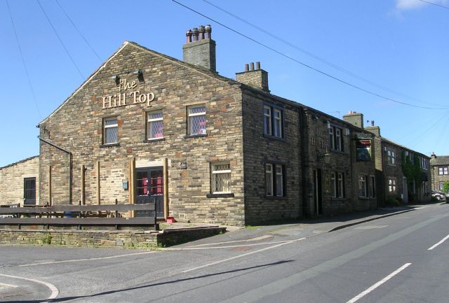
The Hill Top – Hill Top Road, Thornton
© Copyright Betty Longbottom and licensed for reuse under this Creative Commons Licence.
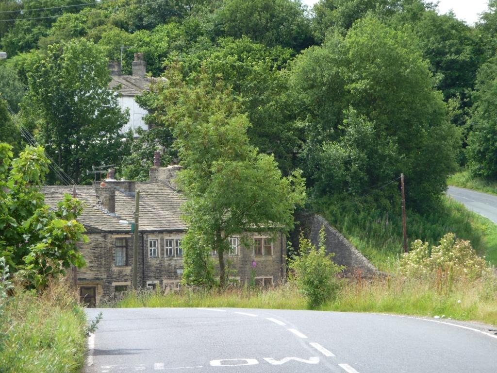
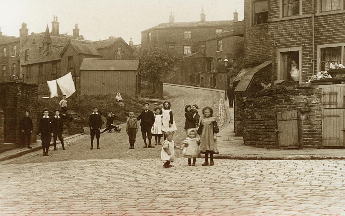
Hill Top Road on the 1891 map it is named. The photograph, whose copyright owner is not known, shows the start of Hill Top Road at its junction with West Lane and Roundfield Place. The house on the right is one end of Roundfield Place which are houses on West Lane. The buildings on the left and centre are on Hill Top Road. The building with a short steeple is the Mission Hut, now the site of Abe Shaw‘s. There are many Listed buildings on Hill Top Road, which date the area:
- Numbers 9 and 11 are Grade 2, dating from the early 19th century;
- numbers 15 to 21 are Grade 2, dating from about 1820;
- the Hill Top Public House is Grade 2 dating from the early 19th century;
- 29 and 31 are Grade 2, and date from the early 19th century;
- Thompson Square, numbers 57 to 63 (odd), are Grade 2 and consist of a late 18th century farmhouse, altered with cottage additions early to mid 19th century;
- numbers 70 to 90 are Grade 2, and are from about 1820-30 being a long range of sandstone “brick” cottages, slightly stepped up the hill in pairs;
- numbers 102 and 104 date from about 1830 sandstone “brick” with stone slate roof, number 102 is unusual for this date and its modest scale, in having a parapeted front with paired dentil cornice;
- numbers 118, 120 and 122 are all Grade 2 dating from about 1820 to 1830;
- numbers 172 and 174 are Grade 2 and date from the early 19th century;
- numbers 176 to 184 are Grade 2 and date from the early 19th century; n
- numbers 186, 188, and 190 are Grade 2 and date from about 1820 and are set back from the road line;
- and numbers 192 to 204 are early19th century sandstone “brick” cottage row with number 200 at right angles. (Updated 10 December 2022)
Hill Top Road Letter Box On the 1908 shown at the junction of Hill Top Road and Wicken Lane.
Hillcrest Road From West Lane to Oakhall Park
Hirst Fields On the 1908 map. A dwelling where Hirst Field Farm now is, off Black Dyke Lane.
Hobb End On the 1852 map, spelt Hob End. A terrace of houses where Hobb End now is. Spelt as now on the 1891 map.
Holme Laithe Farm House, appears in the 1871 census, in that part of Thornton which was transferred to Queensbury civil parish in the year 2004. Off Pit Lane, (although Pit Lane not mentioned in the census). (Updated 21 August 2023)
Holt Street is referred to in a land sale notice in the Bradford Observer of January 11 1866, viz. “Each of these Lots (lots 2,3,4 and 5) has an extensive south frontage to John Street, and the two latter to Holt Street also.” and in respect of lots 7 and 8, “inclusive of one half of so much of Holt Street, as is co-extensive with lots 7 and 8… These lots abut upon the Bradford and Thonton Turnpike Road, now called the Thornton New Road, and no excavations will be required for cellars.” (Updated 20 June 2023)
Hotels: There will be an entry for each Public House, (including ale-houses, inns, taverns, and hotels). A list of all-known are found under the heading Public Houses. (Updated 20 February 2023)
Hougomont, which is near the Pit Lane end of Low Lane, was in Thornton civil parish until May in the year 2004, since which time it’s been in Queensbury civil parish. Rumour has it that it was given its name as a mark of respect for a soldier or “drummer boy” who lived there, and who was killed in the Battle of Waterloo. The Chateau at Hougoumont served as one of the advanced defensible positions of the Anglo-allied army under the Duke of Wellington as it faced Napoleon’s army in 1815. In the 1849 Tithe Award Simeon Mann and others occupied cottages and gardens where Hougomont is. On the 1852 Ordnance Survey map the houses were described as “New Houses”. In the 1861, one of the New Houses was occupied by Simeon Mann, born in 1798 at Southowram. They were still called “New Houses on the 1934 map. An advertisement in the Halifax Evening Courier for 11 August 1923 is for the sale of 2 cottages, numbered 1 and 3 Hougomont. (Updated 7 August 2023)
Hoyle Ing see Upper Hoyle Ing
Hoyle Ing Road On the 1933 map. Part of the Bradford Corporation Council estate built from the 1920s.From Thornton Road to Old Road. Future car ownership did not appear to have been considered in the planning of the Council estate.
Hughendon Drive a long cul-de-sac eastwards from Chat Hill Road
Hughendon Walk a short cul-de-sac off Hughendon Drive
Hugill Street Shown on the 1933 map, but occupants of houses shown on the 1911 Census. Built on the site of Old Mill. Named after Mr. John Hugill, the Secretary of Keighley Building Society, owner of the Old Mill which was demolished some time around 1905, and Hugill Street built. See also Lane End (Updated 21 October 2022)
Independent Chapel On the 1852 map see Kipping Chapel
Industry Street On the 1891 map. From Thornton Road northwards, stopping before Market Street. On the west side back to backs shared with Commercial Street, on the east side a terrace of single dwellings. Probably built the same time as Commercial Street, about 1851-2. (Map produced with the permission of the National Library of Scotland for non-commercial purposes))

Ing – definition From the Middle Ages, an ing is a grassland or meadow, especially near to a watercourse.
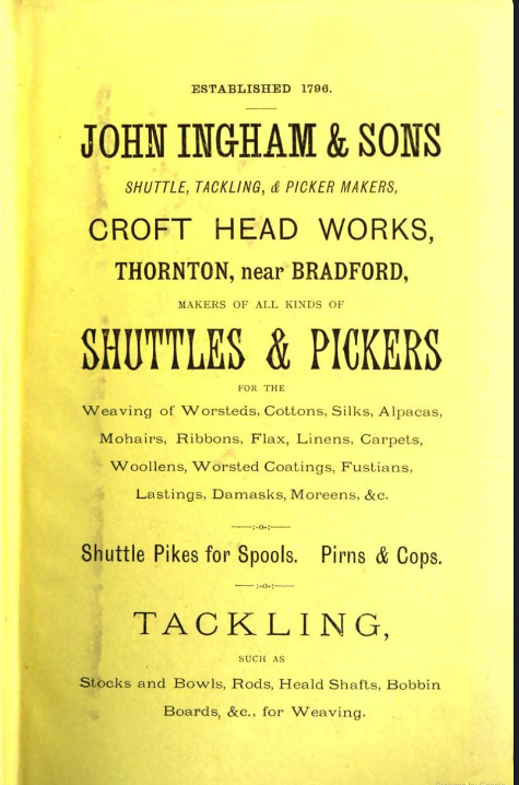
Ingham’s Shuttle Works, Market Street. John Ingham and Son’s works, called Croft Head Works, were roughly where Market Court and Thornton Library are now. An advertisement in the 1885 publication of “A practical treatise on weaving and designing of textile fabrics” states that the firm was established in 1796. The catalogue of the Royal Jubilees Exhibition of 1887 at Manchester includes “460a John Ingham and Sons, Croft Head Works, Thornton, near Bradford. The firm also exhibited at London, Vienna and Paris. The firm ceased trading in the 1930s, and the works were demolished in the 1960s.
Institute and Baths On the 1901 map, the Thornton Mechanics Institute which included bathing rooms. now named. See also Thornton Mechanics Institute
Intake Farm, Cragg Lane formerly called The Intakes, on the 1852 map. An intake is land reclaimed from moorland. Intake Farm and Integral barn are Grade 2 listed buildings, dated about 1830. On the 1849 map called “Intack”.
Ivy Bank Villas are numbers 324 to 332 Thornton Road. The first reference found in newspapers was from 1907. (Updated 3 September 2023)
James Street Known to have been built around 1869/70. Between Thornton Road and West Lane. The Bradford Observer of 8 March 1869 reports that the Thornton Local Board have approved plans for a new street from New Road (Thornton Road) to the Waterworks Reservoir, to be called James Street. The is a land-sale notice in the Bradford Observer of 11 January 1866 which refers to “Firth, William, and James Streets”. (Updated 17 March 2025)
James Street School On the 1891 map. A school built on James Street north of Providence Row and Vine Terrace. The school was converted to 4 dwellings sometime after the re-organisation of primary education in the year 2000 when the school was shut down. The canteen of the school later became a private nursery, currently (2022) run as 1st. Safari Thornton Lodge nursery.
Jane Eyre Lane, see Gleeson development (updated 12 July 2023)
John Street First mentioned in a sale notice in the Bradford Observer of January 16, 1866, “Lot 1 comprises Plot of Land, founded on the north by the centre of an intended new street to be called John Street, and on the south and west by the road leading to Thornton Old Mill.” John Street now goes from Lower Kipping Lane to the start of Hugill Street. (Updated 20 June 2023)
Junction Inn, which is at the junction of Cocking Lane and Brewery Lane at West Scholes, was in Thornton civil parish until May in the year 2004, since which time it has been in Queensbury civil parish. (updated 7 August 2023)
Keelham On the 1852 map called Keelom. On the 1849 Tithe award map called Thornton Lane End. On the 1892 map, recognised as a place. Where Keelham now is. Dwellings where they are now, except for the absence now of any building on the south-west corner of the Keelham crossroads. Turnpike tolls collected here for the Bradford and Thornton Turnpike and the Brighouse and Denholmegate Turnpike. There were buildings on all four corner of the crossroads of the two Turnpike Trusts. Numbers 1189 to 1195 Thornton Road, plus 1 and 3 Brighouse and Denholme Road are Grade 2 listed buildings, dating from about 1800 to 1820. Number 1195 has a deep but narrow 2-storey canted stone bay window with square mullions dividing lights. Number 3 has a corniced doorway, dating from 1840-1850. Numbers 1366, 1368 and 1370 were previously the Brown Cow Inn, plus numbers 7 and 8 Keelham, Brighouse Road are Grade 2 listed buildings dating from about 1820. 1368 had been a Post Office before the three houses were turned into the Inn. 1366, 1368, and 1370 have been converted back to 3 dwellings.
In the 1851 census in the vicinity of Sandal and Upper Sandal, 4 dwellings. (Updated 17 August 2023)
Keelham Bar Farm On the 1933 map On Brighouse and Denholme Road, 2 fields west of Sandal.
Keelham Hall On the 1908 map, previously on the 1852 map called Keelam Hall. The original Keelham Hall farm. Called Keelham Hull in the 1851 census, where it was a farm of 24 acres. (updated 17 August 2023)
Keelham Place On the 1892 map. A terrace of dwellings at Keelham, next to the school, off what was then called Close Head Lane, but is now called Well Heads.
Keelham Post Office On the 1921 map. The 2nd dwelling on the north east side of Keelham crossroads, which is a Gade 2 listed building, described under Keelham..
Keelham School Originally opened on Saturday 12 June 1875, at a cost of £2,450 intended to accommodate 180 children. Shown on the 1892 map at the junction of unnamed former Brighouse and Denholme Gate Turnpike Road, and Close Head Lane (now known as Well Heads). (updated 9 March 2023)
Keighley and Halifax Turnpike Trust
Kellett Drive between Woodsley Fold and Rowlands Close. Named after the TV wrestler Les Kellett who lived in the area for many years in a house called the Brick House.
Kinder Close westwards from West Lane. Named after Ernest Townley Kinder, OBE, JP. Awarded the OBE for services to Disabled People and to the deaf community in West Yorkshire. President, Bradford and District Association for Deaf People. Ernest was also a Conservative councillor for Thornton Ward on the Bradford Metropolitan District Council. (Updated 16 March 223)
King Edward Road From West Lane to King Edward Terrace. Stoneleigh is the oldest house, being built at the same time as the terrace on the east side of King Edward Terrace. It was in the 1910s the home of Alfred and Mary Louisa Farrar. Mr. Farrar was a quarry owner.
King Edward Terrace On the 1908 map. Built on the east side only. A terrace of houses, to the south an attached larger house, Stoneleigh – see King Edward Road..
Kipping On the 1852 map. A house on what is now Lower Kipping Lane, which is now known as Kipping House, see Kipping House below.
Kipping Barn in Lower Kipping Lane. The barn was used as a non-conformist meeting place for the Thornton Independents in the latter part of the C17 and a license was granted to John Hall, who owned the barn and Kipping House, in 1678. see also Kipping House. It is now residential, having been restored after 2001. The barn is listed, grade 2. The listing states: “Early to mid C17 large coursed gritstone barn with stone slate roof. Two storey gable end to road with central squared jamb entrance (up steps) and small squared surround window openings flanking and set above. Ventilation slits just above ground level. On the east side, facing a stone paved yard, is a central full height portal, 4 window range and small pentice at north end. The interior is aisled, later partitions but 3 posts exposed. Shallow King post roof trusses.”

Kipping Cemetery Shown on the 1908 map, now between Alan Court and South Cliffe. A plan of the burial ground and a book detailing interments are in the Thornton Archives at South Square.
Kipping Chapel was originally built where it is on Market Street in 1769, enlarged in 1807 and 1825 and rebuilt in 1843, and the inside was restored around the year 2000. It was reported in the Bradford Observer of 25 May 1843 that there were rumours that the building was unsafe so the trustees asked Mr Metcalfe, an architect, and other experienced people to look at it. Their report determined it was inefficient, so the trustees met and decided to pull it down and have it rebuilt on the same site.
Kipping Chapel is a Grade 2 Listed building; the railings and gate posts at the front of the Chapel are also listed (Grade 2). The 1908 map shows 2 burial grounds, one on the eastern (Craven Avenue) side, continuing to the second to the east of Kipping Manse. Kipping Chapel, and before it Kipping Barn and Kipping House were the centre for religious nonconformists since at least the days of the Long Parliament (1640-1660), and possibly since Elizabethan times (1558 – 1603). Under some monarchs those who did not conform with the Church of England were seen as outlaws (possibly because nonconformists did not swear allegiance to the Monarch). As a result the Kipping Independents met in secret at Kipping House and Barn. William Cudworth in his Round About Bradford, published in 1876 has much more detail on the Kipping Independents, original pages 155 onwards. In the 19th and early 20th centuries Kipping Chapel was most likely the best attended chapel or church in Thornton. The photograph was taken on 16 February 2008.

Kipping Gardens the site of New Road Congregational Church from 1866 to 1982, facing Thornton Road just to the west of Kipping Lane. Became a Bradford Council landscaped park (with seats and grass) and a block of public conveniences. These were demolished around 2006 and towards Thornton Road the area has been improved with a display about the village, more seating and a notice board. Thornton in Bloom planted extra daffodils.
Kipping House in Lower Kipping Lane, is a listed building, Grade 2. English Heritage’s description is: “C17 origin, altered C18 and early C19. Two storey gritstone and sandstone “brick” house. Stone slate roof with saddlestones to gable ends. Corniced chimneys. Flush quoins. Two and four light square mullion windows in squared surrounds. Squared jamb doorway. Small eared architrave surround late C18 windows to east gable end. Plan elevation has 3 C19 sash windows with cornices on consoles.” It is important also as one of the places where non-conformists met in the 17th century, along with Kipping Barn. It is thought that non-conformists were worshipping there as early as the 1660s. It is known that under the Toleration Act of 1689 it was a place registered for worship by non-conformists.
Kipping Lane On the 1891 map: Between Thornton Road and Market Street. Kipping Lane before 1829, (when Thornton Road was built from Leaventhorpe Hall to the main Keighley to Halifax Road), was one of two roads connected to the end of Market Street (then called Main Street. It continued to Alderscoles Lane, Squirrel, (also known as Swirrel), leading to Malt Kiln Lane, Deep Lane and Cragg Lane, also known as Bottomley Holes. The other main road from Market Street was West Lane. Significant buildings on Kipping Lane are Rose Cottage, the former home of Jonas Craven, of the textile firm of Craven and Harrop, and the 3 storey cloth warehouse which later became Amblers Butchers and pie bakers. Fuller details of Kipping Lane, the first of the “Streets through time” can be seen here. (Updated 11 August 2025)

Kipping Manse On the 1891 map: Built but unnamed, to the south of Kipping Chapel overlooking Thornton Road.
Kipping Place on the 1891 map, and named on the 1908 map, leads from Thornton Road to Lower Kipping Lane, cobbled and without a name plate. Further information: while checking on the addresses of Jonathan Northrop, the founder of Albion Mill, I found a different Jonathan Northrop living at 37 Kipping Place in 1871. Further research showed houses in Kipping Place from 1861 to 1921. Newspaper reports show that te houses on the west side of the street were occupied at least untl the 1940s.The photo, taken in May 2023, shows Kipping Place as it is now, with a tree growing across the road. The tree comes out of the side of the former Wellington pub. Kipping Place in the news:
- 1872, February 1. S Geldard of 37 Kipping Place, was declaring he was supporting Isaac Holden, Liberal, in a general election.
- 1873, September 8, in the Bradford Observer, noting the death of Ishmal Pollard, aged 23, of Kipping Place.
- 1881 March 28. In the Bradford Daily Telegraph a report that Stephen Geldard, stone merchant, of Kipping Place was seeking re-election to the post of Overseer of the Poor. He must have been re-elected as he was seeking re-election again in 1882, and in 1885.
- 1889, February 9, in the Bradford Daily Telegraph: “Cottages, six, and two through houses for sale, Kipping Place. Apply Midgley Priestley, Thornton, or A. Geldard, 28 Athol Road, Maningham.“
- 1889, May 23. An advertisement about a forthcoming sale of two houses in Fountain street gave the Solicitor’s addresses, Raywood M Stansfeld, as 13 Cheapside, Halifax, and Kipping Place, Thornton.
- 1937, March 19, the Bradford Observer carried a notice of the death of Esther Butterfield of 1 Kipping Place.
- 1938, March 16, in the Bradford Observer, the following advertisement, “Thornton, to close a Trust: through house, 399, Thornton Road; contains cellar-kitchen, living-room, sitting-room, three bedrooms and attic; in excellent condition; electric throughout; vacant possession. Also three cottages, and one through house, numbers 1, 5, 2, 3, and 4 Kipping Place; offers, apply Ellerton, 35 Back Heights Road, Thornton.”
- 1946, November 8, an advertisement in the Bradford Observer from Mrs. R. Bower of 5 Kipping Place, offering for sale a “High Pedigree Golden Spaniel puppy, (male)….” (Updated July 2 2023)

Kipping Place in May 2023, un-named and with an elder bush growing out the side of the closed Wellington Inn. It is a public highway.
Kipping School (Ind) Shown on the 1852 map. On the south side of Market Street. The first Kipping Sunday school, sometimes called the Kipping Sabbath School, was at 59 Market Street where a carved stone, as in the photo, still remains.

That school was used for meetings in the village. The original Mechanics Institute met in the school in the 1840s as did the Thornton Temperance Society. The Leeds Times of 1 February 1840 report on a numerous and influential meeting in Kipping School-room which agreed to petition both Houses of Parliament for the repeal of the Corn Laws. The Halifax Guardian of 20 January 1844 reported that a meeting had been held in the Kipping School room with the purpose of establishing a Day school connected to the Kipping Independents. The Bradford Observer of 16 April 1846 reported on the opening of the new Kipping School, with accommodation for 700 scholars.
By 1886 larger premises were needed. The Leeds Times of 24 April 1886 reported that the 1846 building would be pulled down and replaced with a larger building containing 20 classrooms and a large assembly hall. The Leeds Mercury of 20 July 1886 reported that the memorial stones of the new Kipping Independents Sunday School were laid by Mr. Joseph Craven M.P. and Mr. Briggs Priestley M.P. Mr. Joseph Priestley was seen as a friend of Thornton and Kipping Chapel. Mr. Briggs Priestley had been born in Thornton in 1831 and had been Superintendent of Kipping School.
The Bradford Daily Telegraph of 9 April 1887 reported that the new Kipping Sunday School had been opened the day before. In the afternoon a public tea was held at which there were nearly 500 people present. n the evening (a Friday) there had been a sacred concert had been held. The Bradford Daily Telegraph of 17 June 1886 reported that in connection with Queen Victoria’s Jubilee celebrations, Mr. Joseph Craven, M.P. will provide a substantial tea in Kipping Sunday School room, for persons in the district over 66 years of age, who each would also receive from him a gift of a new shilling. The choir from Kipping Chapel would entertain the party with music after the tea. 218 people aged between 64 (not 66) and 87 were eligible, but 20 were unable to attend.
The 1886 Kipping School building was demolished in the 1970s.
For other sections of this page, click / press the appropriate button
