For other places click / press on the appropriate button
Sackpit Lane. In the 1841 Census. A former name of Sapgate Lane. In August 1865 it was reported that the Thornton Local Board had decided to rent a room for its clerk in Sack Pit Lane. (Updated 11 February 2024)
Sacred Heart Roman Catholic Church A report in the Bradford Observer of 1 November 1938 states that Sacred Heart Church was originally built in 1930 as a Chapel of Ease under St. Williams Church. In the article it states the Revd. Father William Backhouse was to be the first Thornton Parish Priest. Sacred Heart was closed and demolished some time around early in 2010, due to a reorganisation of the Roman Catholic diocese. Its war memorial is now in Thornton Community Centre. (Updated 20 March 2026)
Sacred Heart Catholic Church – Old Lane, Thornton
cc-by-sa/2.0 – © Betty Longbottom – geograph.org.uk/p/691858
St. George’s Buildings, shown in the 1861 census, in the vicinity of Guy House / Gate End, Mountain, in that part of Thornton which was transferred to Queensbury civil parish in the year 2004. (Updated 19 October 2023)
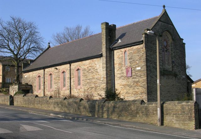
St. James Church was built in 1870, on the north side of Thornton Road. It is a Grade 2 listed building. Its listing states: “1870 parish church of T.H Healy. A simple but large church of sandstone “brick” with ashlar dressings. Tall nave with shallow cusped lancets to clearstory and low aisles with triple groups of lancets. Rose windows to west and east. Tall south-east tower with plain quoin buttresses to bell stage, strings, false machicolation and broached stone spire. The tower is a prominent landmark on the Thornton hillside. Large interior with south aisle arcade. Font of 1679 from the old chapel, with small octagonal bowl. The east window has late Morris and Co stained glass.” The church also includes memorial plaques from the old bell chapel opposite. (updated 24 February, 2023)

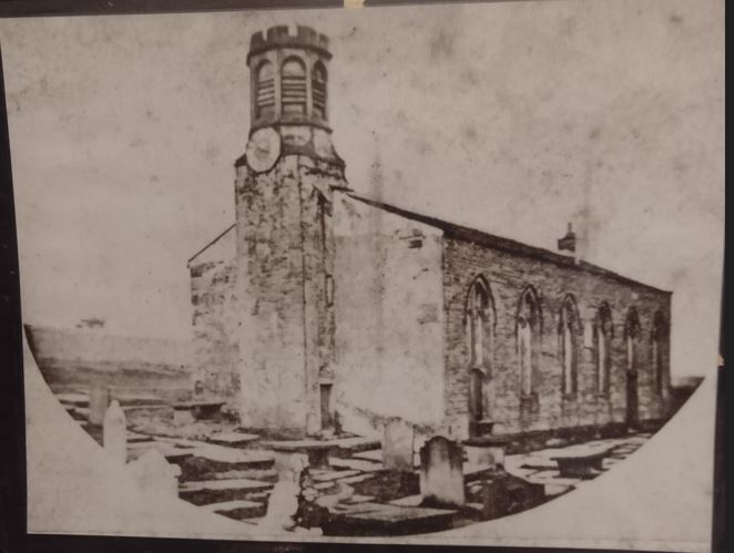
St. James Church (Perpetual Curacy) shown on the 1852 map Now known as the St. James (Old Bell Chapel), but then a built church. The remains are Listed buildings, Grade 2. The Listing states: “Ruins of Thornton’s late medieval church rebuilt in 1612 and then in 1818 when in the care of Rev Patrick Bronte, father of the Bronte sisters.” (Updated 22 August 2024)
Salt Pie shown on the 1852 map. A dwelling at the junction between Cliffe Lane and a Bridle Road leading northwards over Pitty Beck to Yew Tree and Lower Pikeley (both now in the Allerton part of the Thornton and Allerton ward). The Bridle Road is named on the Tithe Award map (1849) as Small Lane, and the Cliffe Lane end of it, where Salt Pie is, was named Small Lane Head. An advertisement in the Bradford Observer of 14 May 1840 confirms the names of Salt Pie and Small Lane Head. (Updated 24 February 2023)

Sam Bens in the 1851 census, appears to be near Mountain, in that part of Thornton civil parish which in the year 2004, was transferred to Queensbury civil parish. The person who wrote up the census from returns made, seemed not to be good at spelling. The census gives the occupant as Joseph Gomersal, a farmer of 21 acres. The 1849 Tithe Award shows Joseph Gomersall as occupying land on Brighouse and Denholme Road, east of Travis, and opposite the Raggalds junctions. (updated 17 August 2023)
Sand Pit in the 1861 census, in that part of Thornton civil parish which in the year 2004, was transferred to Queensbury civil parish. 2 dwellings, location somewhere near Law Hill(?). (updated 18 August 2023)
Sandal in the 1851 census, shown on the 1905 map. A dwelling south east of Black Carr Farm and south of Higher Sandal. (updated 17 August 2023)
Sandal Beck On the 1852 map, a stream rising near its junction with Brighouse and Denholme Road and flowing into Pitty Beck west of Brow Bottom. (Updated 25 February 2023)
Sandmoor Close off Corrie Street. (updated 25 February 2023)
Sapgate Lane In the 1841 Census referred to as Sack Pit Lane. Shown on the 1852 map. The area around its junction with Market Street is congested. On the 1891 map that area has been re-arranged as now. It runs to North Cliffe Lane at its junction with Cliffe Lane.
1, 3, and 5 are Grade 2 listed buildings, their listing stating: “Circa 1800-20 cottage row raised on terrace above cobbled street. Two-storeys, sandstone “brick”. Stone slate roofs with corniced chimneys. Single and 2 light square mullion windows in squared surrounds. No 5 has modern glazing bar sashes and bow. Squared jamb doorways. Important position at foot of hill. Included for group value.”
Numbers 15 to 21 are also Grade 2 listed buildings. Their listing states: ” Circa 1800-20 cottage row similar to Nos 2 to 6 (even). Stone slate roofs, corniced chimneys. Flat wood gutter to eaves. Single and 2 light square mullion windows in squared surrounds. Squared jamb doorways. Included for group value.”
Numbers 23 to 31 are also Grade 2. Their listing states: “Circa 1800-20 cottage row to north of Nos 15 to 21 (odd) (q.v.). Sandstone “brick” with stone slate roof, corniced chimneys. Two and 3 light square mullion windows in squared surrounds, some altered. Squared jamb doorways. Included for group value.”
Numbers 2, 4 and 6 are Grade 2 listed. Their listing states: ” Circa 1800-20 cottage row. Two-storeys, sandstone “brick”. Stone slate roofs with spaced lentils to eaves. Corniced chimneys. Single and 2 light square mullion windows in squared surrounds. Squared jamb doorways. Included for group value. (updated 2 March 2023)
School Green On the 1852 map and the 1849 Tithe map there are dwellings and an endowed school dating from 1673 (the original Thornton Grammar School). In later maps there are more dwellings, including from the 1920s Council houses set back from the road on its western side. There’s a view of this and School Green in about 1938 at the start of a film about Thornton Grammar School.
41 School Green is a Grade 2 Listed building. Its listing states: ” Built as single storey, 3 bay school circa 1830. Sandstone “brick” with ashlar dressings. Stone slate roof with spaced block brackets to eaves, coped gable ends with corniced chimneys. Two windows to both fronts. Paired narrow segmental headed lights with chamfered mullions. Doorway to south front in squared surround with ashlar lintel. Included for group value.”
Numbers 25 to 35 are also Grade 2 Listed buildings. The listing states: “Circa 1800-20 row of back to back sandstone “brick” cottages. Stone slate roofs with spaced dentils to eaves, corniced chimneys. First floor sill band. Single and 3 light square mullion windows on first floor, 2 light on ground floor, all in squared surrounds. Plain squared jamb doorways. Included for group value.”
Numbers 35A, 37 and 39 are also listed buildings. The listing states: “Mid C18 farmhouse altered as 2 cottages circa 1800-30. Two-storeys, painted gritstone. Stone slate roof with moulded stone eaves. Saddlestone with kneelers to east gable end. Two and 3 light square mullion windows in squared surrounds. Similar window to rear and large mullion and transom stair light.”
School Green Avenue was built in the 1920s. The Council in those days obviously thought that there would not be any expansion in car ownership, it being a narrow road.. Runs from Thornton Road to Old Road. (Updated 25 February 2023)
School Green Hotel is shown on the 1891 map. At the junction of Chat Hill Road and Thornton Road. It closed about 2016 and is a private house. It appears that the School Green Hotel was moved a short distance in 1931 – see the last newspaper item, below.
- The earliest newspaper reference to the Hotel is in the Bradford Observer of 30 August 1873 reporting that David Summerscales had been granted a licence for the hotel.
- On 3 September 1875, David Summerscales was summoned for being drunk in the hotel and the license was transferred.
- The Bradford Daily Telegraph of 12 April 1900 reported on an inquest held at the School Green Hotel by the City Coroner, Mr. J. G. Hutchinson, relative to the death of Arthur Garner, the 5 months old son of John James Garner of 4 School Green, who was found dead in bed by his mother. A verdict of “Accidentally suffocated” was returned.
- An article in the Bradford Daily Telegraph of 22 June 1900 refers to 6 pigeons engaged in carrying messages from the besieged Ladysmith to Durban during the Boer War. A former member of the Airedale Pigeon Club, Mr. Hirst, had been in charge of the pigeons, and had sent them to a Mr. Thackray of Clayton, via the steamship, Norman. They were to be on display on the following day, a Saturday, at the School Green Hotel, Thornton for a few days, in aid of the Mayor’s War Fund.
- The Yorkshire Post of 2nd January 1931 reported that the Finance Estimates Sub-Committee of Bradford Corporation had decided to approve and agreement with J. Stocks Ltd., of Shibden Head, Halifax, for the purchase of the School Green Hotel, Thornton, and its re-erection of an adjoining site, to allow for widening of Thornton Road at the Chat Hill junction. The “new” School Green Hotel bears the date 1932 on its front wall. (updated 23 February 2023)
School Green Letter Box (1905) near the School Green Hotel
School House Green On the 1849 Tithe map. The area of land shown to the north of the present School Green. (Updated 25 February 2023)
School Ridge A terrace of dwellings running at a right angle to Upper Heights Road. Numbers 1 to 9 plus barn are Grade 2 Listed buildings. Their listing states: “Early C19 stepped cottage row. Thin sandstone “bricks”. No 1 now incorporates 2 cottages and a barn adjoins dated 1836. Stone slate roofs. The gable end of No 9 has saddlestone. Corniced chimneys. Single and 2 light square mullion windows in squared surrounds. Similar rear windows. Squared jamb doorways. The barn adjoining No 1 has 2 windows at ground and first floor levels flanking segmental voussoir archway with triangular dovecote above. Moulded stone eaves cornice. Included for interest as an early C19 vernacular group.” (Updated 25 February 2023)
School Rig On the 1852 map appears to be a dwelling off Upper Heights Road at its eastern end. (Updated 25 February 2023)
School Street is the un-named road leading from Market Street to Ellingham Court. (Updated 25 February 2023)
Sewage Works (Bradford Corporation) (1905) to the south of Prospect Mill and south west of dwellings on Green Land (lower part)
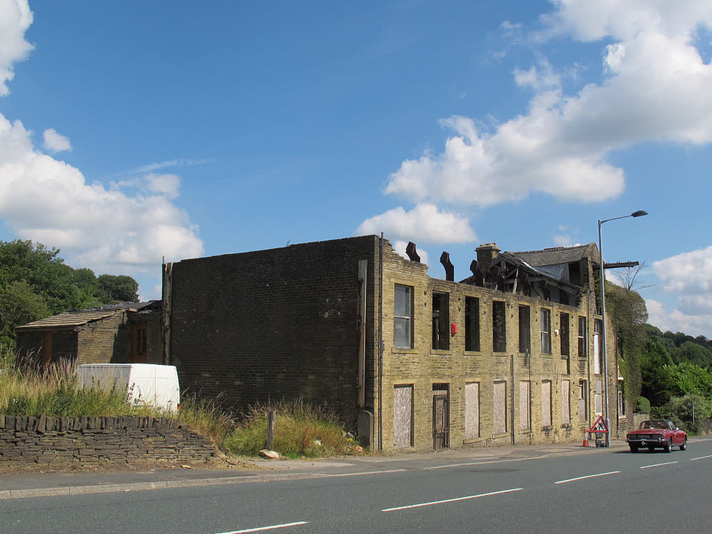
Shawl Mill is not named on any map, or named Pearson Place. Today it’s in a sorry state as seen in the 2015 photograph. It was owned and run from 1860 to at least 1901 by brothers Joseph and David Craven, making Victorian shawls. The Mill is just in the Green Belt opposite the entrance to Myers. Where Myers is was a Coal mine. (Updated 23 February 2023).
© Copyright Stephen Craven and licensed for reuse under this Creative Commons Licence.
The Shay (1) Buildings shown on the 1852 map, on the left-hand side corner, while travelling away from Thornton at the junction with the Keighley to Halifax Road, Later called Shay Fold. Some of the buildings remain today. (Updated 26 February 2023)
The Shay (2) on the 1852 map, the area of land above about 1075 feet high, leading from south of the Keelham crossroads to the Calderdale boundary. 7 coal pits are shown nearer the brow of the hill. (Updated 26 February 2023)
Shay Bottom Shown on the 1852map a dwelling, on the south side of Brighouse and Denholme Turnpike Trust, opposite New Close. Now called Upper Shay Farm. (updated 26 February 2023)
Shay Farm (1) On the 1892 map. on the same track further south of Trash Hall, off Brighouse and Denholme Road, now called Far Shay Farm. (Updated 26 February 2023)
Shay Farm (2) An un-named building whose driveway is opposite the top of Deep Lane, off Brighouse and Denholme Road, called Shay Farm, is a Grade 2 listed building. It’s official list entry states: “Shay Farmhouse and Integral Barn, Set back up lane. Late C18 or circa 1800 farmhouse. Two-storeys sandstone “brick” with dry stone walled back at east end on long house pattern. Stone slate roof, shaped kneelers to gable ends. Three windows, 2 light square mullions. Plain doorway with squared jamb, Corniced chimneys.” (Updated 26 February, 2023)
Shay Fold on the 1892 map dwellings, called in 1852 The Shay (1) A group of dwellings near the Thornton Road / Halifax Road junction. (updated 26 February 2023)
Shillicake A report in the Bradford Observer of 16 June 1954 refers to the little cottage in Shillicake Wood.

The article says that nothing remains of the white-washed cottage in a clearing in the woods, and that the wood was cut down for pit props between 1914 and 1918. An extract from Google Earth shows where I believe Shillicake was, on the Allerton civil parish side of Pitty Beck. The farm, whose land this is, is called Shillicake Farm, which is also in Allerton civil parish, but still considered to be Thornton. To the north of the existing trees was a belt of trees, with a clearing, bounded by parallel stone walls. At the top of this clearing was Shillicake Cottage. In an In an article in the Telegraph and Argus of 20 November 2004, in relation to a query as to the origin of Shilley Cake Bank, a reader stated that it was an example of a very old name that has continued in use long after the original meaning was lost. “Shilley” he says, is made up two elements of Old English, sceap and leah, which means “the woodland clearing where sheep are kept.” Added to this is the Old English cocc meaning a heap or hillock. The meaning is now “The heap or hillock at or by the sheep clearing.” The word “bank is of Scandinavian origin, (OS) “banke” and was added much later. Thornton Roll of Honour published in the Bradford Weekly Telegraph of 17 September 1917, a person with the surname of Firth is listed at Shillicake Cottage. Unfortunately no forename is given, so searches for more information about him are very difficult. See extracts ©Google. (Updated 30 July 2025)

Shillacake Cottage was at the tree end of the walled section
Shirley Mews, see Gleeson development (updated 12 July 2023)
Short Way A cul-de-sac southwards from Old Road. Does not appear in the 1939 Register, so built later. (Updated 18 March 2023)
Shuttle Street is in the 1861 Census, and was near to Priestley Street. I appears to have been a former name of Friendly Street, as indicated by a land sale map, dated December 1865, in the ownership of Bradford Local Studies Library. (Updated 17 March 2025)
Sky Lark Shown on the 1849 Tithe map: A dwelling on the boundary with Calderdale, accessed from Brighouse and Denholme Road, thought to be in the vicinity, and lost to, opencast clay and stone extraction.
Small Lane On the 1849 Tithe award map a lane from the end of Cliffe Lane from what is now Salt Pie Farm to Allerton Upper Green. On the 1891 OS map it is unnamed but leads to the road between Yew Tree and Lower Pikeley. (Updated 26 February 2023)
Small Lane Head see Salt Pie
Small Tail On the 1852 map: Dwellings close to the ward boundary just to the north of dwellings on Mucky Lane (see Lane Bottom for an explanation of Mucky Lane). On the 1849 Tithe Award map this area was known as Greenland. (Updated 2 February 2023)
Smith Field occurs in the 1841 census, between entries for Garden Top and Main Street. It is not obvious where it was. (Updated 7 May 2023)
Smithey in the 1851 census, near Mountain or Travis, in that part of Thornton which was transferred to Queensbury civil parish in the year 2004. The occupants of working age were coal miners plus 2 pit boys. (Updated 18 August 2023)
Smithey Hill in the 1861 census, in that part of Thornton civil parish which in the year 2004, was transferred to Queensbury civil parish. 3 dwellings including a Beerhouse. (Updated 18 August 2023).
Smithies 1. (1905) adjoining the back of the east side of South Square. On the 1921 map, not named. 2. (1905) West of Woodsley (house) on Thornton Road. On the 1921 map, No longer west of Woodsley. 3. On the 1821 map, East of Black Dyke Lane Quarry. 4. At School Green.
Sough Hall Shown on the 1849 Tithe Map as being south of what was originally called Lower Mill. Slough Hall consisting of “house, barn, stable and cottages was owned, and lived in, by Abraham Ackroyd. (Updated 26 February 2023)
South Cliffe off Thornton Road down the western side of the Motor Services Garage. (Updated 26 February 2023)
South Square Dated 1832. Shown in the 1841 census. To the south of Thornton Road, to the east of Priestley Street. 377 and 399 Thornton Road, and 1-9 South Square are grade 2 listed buildings. The listing states: “Includes Nos 377 and 379 Thornton Road. Small cul-de-sac close, on the south side of Thornton Road and forming in part one side of Priestly Street, Nos 2 and 4 of the latter back to back with the Square’s south-west corner. Dated 1832. Two-storey sandstone “brick” cottages increasing to 3-storeys on south front and with slightly more formal 3 bay fronts to Thornton Road (Nos 377 and 379). Stone slate roofs, hipped over Thornton Road fronts. Corniced chimneys. Stone eaves have spaced dentil brackets. Single and 2 light square mullion windows in squared surrounds. Squared jamb doorways. Nos 377 and 379 Thornton Road have 3 bay fronts with console corniced doorways similar to and balancing Nos 381 and 383.” (Updated 2 March 2023)
South Street First appeared in the 1881 Census. From Reservoir View to open ground. Shares back-to-backs with Cliffe Street. (Updated 7 March 2023)
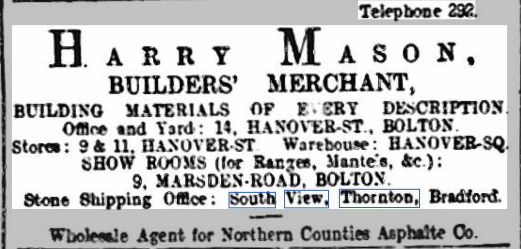
South View, first appeared in the 1901 Census, though a reference to South View is found in a newspaper advertisement dating back to 2 November 1898 from the Bolton Evening News of that date, (© copyright of the Find My Past website) – see copy of the advert. South View is off Upper Heights Road close to East View. (Updated 7 March 2023)
Sowden Grange Houses built on the former garden of Sowden House, James Street. (Updated 2 March 2023)
Sowden House was built near the junction of James Street with West Lane, at some stage between 1852 and 1891. The name of the field it was built on was Sowding, according to the Tithe Award Map. Originally a private house it later acquired a large garden. Later it was a residential home for older people, and then became a children’s residential home called Rowan House. The large garden was sold off for housing and is now called Sowden Grange. (Updated 23 November 2024)
Sports Ground and Pavilion, off Leaventhorpe Lane, opened on 27 June 1931, built by voluntary fund raising by Thornton Grammar School. It can be seen on the film about Thornton Grammar School between 2 minutes 22 seconds and 3 minutes 32 seconds. (Updated 14 September 2024)
Spring Field See Springfield Street
Spring Gardens first appeared in the 1861 Census. The Leeds Intelligencer of 27 October 1849 refers to the then recent death, in his 7th year, of William James, eldest son of Mr. Samuel Sugden of Spring-gardens, Thornton. A group of dwellings on both sides of Sapgate Lane. Location not currently pinpointed (Updated 7 March 2023)
Spring Hall on the 1852 map. A house just off West Lane at the end of a footpath from Market Street which goes across Sap Gate Lane, Havelock Square and Back Field coming out where Wold Close now is. (Updated 2 March 2023)
Spring Halls see Spring Holes
cc-by-sa/2.0 – © Alan Murray-Rust – geograph.org.uk/p/6678716
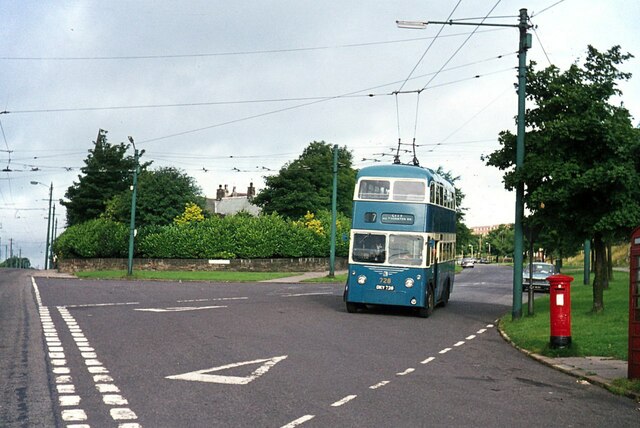
Spring Head Road was built in the 1920s, except for the top end, after its junctions with North Cliffe Drive and Green Mount Road. The earliest reference in newspapers is in the Yorkshire Post and Leeds Intelligencer of 31 October 1928 reporting the death of Mr. Frank Rhodes, aged 42, of Spring Head Road. He was a corn miller and was found injured at the mill. He died later at the Infirmary. Spring Head Road runs from Thornton Road to a cul-de-sac at its western end. At an unknown, as yet, date a trolley bus turning circle was built at the junction of Springhead Road and Thornton Road. The photograph shows a trolley bus on Springhead Road in 1971. (Updated 7 March, 2023)
Spring Head Terrace is shown in the 1871 Census. Dwellings south of the junction of Back Heights Road on what is now Springholes Lane. (Updated 4 March, 2023)
Spring Holes On the 1852map: Dwellings where dwellings now are to the east of Spring Holes Lane. That area called “Spring Halls” on the Tithe Award map of 1849. (Updated 4 March, 2023)
Spring Holes Lane from West Lane to Hobb End. Appears with this name in the 1871 Census. (Updated 4 March, 2023)
Spring View shown on the 1891 map. Dwellings at the junction of Lower Heights Road and Upper Heights Road. (Updated 4 March, 2023)
Springfield Hotel On the 1891 map, at the eastern entrance of Market Street. The Springfield closed many years ago. It has been derelict for over 11 years. See also Fawthrop Hotel (Updated 21 February 2023)
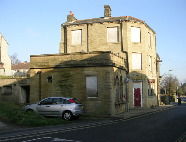
© Copyright Betty Longbottom and licensed for reuse under this Creative Commons Licence.
Spingfield Street shown on the 1891 map as Spring Field. Runs north from Market Street. Numbers 2 to 16 are Grade 2 Llisted buildings. The Official Listed Buildings entry states “About 1810-20 terrace decreasing in height from the 4-storeys of No 2, on corner with Market Street, to 2-storeys and basement as the street climbs hill. No 16 however is stepped up. Terraced middens with plain railings in front. Platbands between floors. Hipped ends to stone slate roofs. Corniced chimneys. Moulded stone gutter on dentil brackets. Single and 2 light square mullion windows in squared surrounds. Squared jamb doorways. Return front of No 2 to Market Street has small shop front and 2 light square mullion windows to upper floors. Lead rainwater head, and downpipe, dated 1819.” (Updated 4 March, 2023)
Squirrel / Squirrel Lane shown on the 1852 map. A group of houses as now from Malt Kiln Lane to Cragg Lane. On the 1849 Tithe Award map called Swirrel. On the Lane Green Cough Farmhouse and Barn are Listed buildings. The List states: “Late C18 farmhouse with barn under same roof and slightly later circa 1800, north-east wing. Two-storey, sandstone “brick” partly dry walled. Stone slate roof with saddlestones, shaped kneelers. Main front to each with ashlar quoins. Five light square mullion windows on first floor, 3 light on ground floor, both in squared surrounds. Single-storey outshut and squared jamb doorway. Plain barn with massive ashlar lintel to portal. The north-east wing has no quoins. Coupled single light squared surround first floor windows and 2 light square mullion windows on ground floor. Return to barn has small round-headed light cut out of single block. Saddlestones to gable ends with crisply sawn shaped kneelers. The south gable end of farmhouse has a 2 light and former 4 light square mullion windows, squared surrounds. Outshut to road front.” (Updated 4 March, 2023)
Squirrel Fold see Gleeson development (updated 12 July 2023)
Squirrel Hill (1) On the 1852 map A hill between Hill Cottages and Keelham Hall to the north west of Deep Lane. On the 1849 Tithe Award map called Swirrel Hill. (Updated 4 March 2023)
Squirrel Hill (2) In the 1851 census and on the 1852 map The name of some dwellings off Deep Lane, north side, north of Higher Sandal. On the 1891 map called Squirrel Hill Farm. Squirrel Hill Farmhouse is a Grade 2 Listed building. Its listing states: “Sandstone “brick” farmhouse of C17 origin but largely rebuilt and refaced with thin “bricks” circa 1800. Stone slate roof; saddlestones to gable ends with caveto moulding carried out as capping to kneelers. Date of 1687 inscribed in south-west kneeler. Two and 3 light framed square mullioned windows, mostly enlargements of 4 or 5 light ones. Squared jamb doorway with stone gable hood. Lower cottage extension also with square mullioned windows. Rear outshut.” (Updated 17 August 2023)
Star Inn was at 1 Havelock Square The earliest newspaper reference to the Star Inn is from the Bradford Daily Telegraph of 21 November 1876, when Samuel Watson and Newton Bower, 2 lads aged 15 and 11 respectively, were charged at the West Riding Court in Bradford, with having stolen a quantity of tobacco, the property of Jane Looms, of the Star Inn, Thornton. The lads pleaded guilty, and their parents and guardians promising to look after them in future, they were ordered to be imprisoned until the rising of the Court on that day. (Updated 25 February 2023)
Station Letter Box shown on the 1933 map, at the Thornton Road entrance to the railway station.
Staverton Grove a cul-de-sac from Oakhall Park, built around 1999-2000. (Updated 26 April 2023)
Steelers see Brooklands
Stocks The remain of Thornton’s stocks are in the grounds of Thornton Hall. (updated 6 April 2025)
Storr Heights 2 houses appear in the 1861 Census, 3 in 1871, 35 in 1891, and 8 in the 1821 Census. The name given to the terrace of dwellings on Sapgate Lane, (north-western side) immediately prior to the junction with Back Lane. (Updated 7 March 2023)
Storr Heights Quarries On the 1852 map, an area around what is now Back Lane, including a large sandstone quarry between Back Lane and Sap Gate Lane. On the 1921 map this area is now marked “Disused”. (Updated 4 March 2023)
Storrs On the 1852 map, a dwelling off what is now Cliffe Lane, now called Storr Hall Farm. (Updated 4 March 2023)
Stott Gap of the east side of West Lane opposite the Wicken Lane junction. (Updated 12 June 2023)
Stream Head On the 1852 map, a dwelling to the west of Low Stream Head, now called Manor Farm, in Allerton civil parish. (Updated 4 March 2023)
Sugden Buildings in the 1861 census, probably near Law Hill, in that part of Thornton which was transferred to Queensbury civil parish in the year 2004. (Updated 18 Agust 2023)
Sun Inn, a Webster’s pub on the corner of West Lane and Wicken Lane. The photograph was taken in 2008. It closed down some years ago and is now a private dwelling. (Updated 4 March 2023)
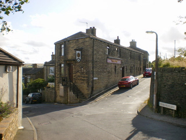
© Copyright Alexander P Kapp and licensed for reuse under this Creative Commons Licence.
Sun Side pm the 1852 map, an area south of The Shay (1). (1892) An area at the Thornton Road / Halifax Rod junction on the west side of Halifax Road. (Updated 4 March 2023)
Sunday School (Kipping) It was originally established in 1804, but the building shown on the 1891 map was built much later. It was south of Market Street and west of Bridge Street where social housing for older people is now. The 1905 map shows there was a burial ground there. (Updated 8 March 2023)
Sunny Bank was shown on the 1891 map. It is a dwelling at the top of High Street. (Updated 8 March 2023)
Swine Market, see Back Field
Swirrel see Squirrel
Telephone Call Boxes shown on the 1933 map: 1. At the bottom of Albert Street on the west side. 2. On Thornton Road near to the unnamed Great Northern Hotel. 3. At Keelham crossroads. 4. At the junction of Spring Head Road and Hoyle Ing Road.
Tennis Court is shown on the 1933 map. The court was built before October 1929 when the Yorkshire Post and Leeds Intelligencer reported (on 14 October 1929) on why the Council’s Parks’ income was down, quoting Alderman Horsfall as saying ” Before we started with tennis in the parks, I do not think there was one tennis court in Thornton. Now, I believe, there are three…As a result our receipts go down. They come to the parks only when their own courts are full.” The court was south of the Bowling green. In the early 21st century, around 2006, they were replaced by a Multi-Use Games Area. South of the Bowling Green (Updated 20 March 2023)
Ten Yards Lane shown on the 1852 map, where it is now between Thorngate and Half Acre at Moscow. (updated 17 March 2023)
Tewitt On the 1905 map, a building on what is now Tewitt Lane (unnamed lane). (Updated 17 March 2023)
Tewitt Lane (unnamed) on the 1891 map, has been built. Runs from Ten Yards Lane to Black Dyke Lane, apparently named after the dwelling called Tewitt. The crossroads between Black Dyke Lane, Old Allen Lane and Tewitt Lane have been built. (updated 17 March 2023)
The Professor Close, see Gleeson development. (updated 12 July 2023)
Thompson Square first appears in the 1861 Census, when it was 6 dwellings, south of Hill Top Road, dwellings on the west side, leading to what is now Hill Top Farm. Now known as numbers 57-63 Top Road. Thompson Square are Listed buildings. The Listing states: “Late C18 farmhouse, altered with cottage additions early to mid C19. Sandstone “brick”, flush quoins, saddlestones and kneelers to original farmhouse. Some 2-light square mullion windows intact. Included for group value.” (Updated 4 March 2023)
Thorn Gate shown on the 1852 map, at the junction of Tewitt Lane and Ten Yards Lane, thought to be a Gate to the former Denholme Deer Park. (updated 17 March 2023)
Thorn Gate Plantation shown on the 1852 map, a large area of tree planting on the east side of Ten Yards :Lane and south of what is now Tewitt Lane. (updated 17 March 2023)
Thornfield Hall Shares its name with a fictional location in Charlotte Brontë’s Jane Eyre, but is not a gothic building but, dating from 1987, a sheltered housing scheme in Thornton, Bradford, consisting of self-contained one bedroom flats suitable for the over 55’s, run by Accent Homes. It is built between Ball Street and what was Industry Street, and over what was the lower half of Commercial Street, and is set back from Thornton Road, next to what was Kipping Manse. (updated 17 March 2023)
Thornton origin of name: From the Old English, Torenton, for a hawthorn tree plus the Old English for a farm or settlement. (Updated 17 March 2023)
Thornton Cemetery Opened in 1907 but shown on the 1905 map. The War Memorial in the lower part of the cemetery is a Grade 2 Listed structure. (updated 17 March 2023)
Thornton Colliery shown on the 1891 map, south of Thornton Road opposite a detached house east of Albion Place. (updated 17 March 2023)
Thornton Conservation Area Sadly it is on Historic England’s listed buildings at risk register. People living within the Area not undertaking their duties in respect of buildings. Estate agents tend not to inform potential buyers that a building is in the Conservation Area, and some don’t tell potential buyers that a building is listed. (updated 17 March 2023)
Thornton Corn Mill shown on the 1852 map. Opposite Fall Bottom on the Thornton side, on a path / road between Cocking Lane and Coach Road. Noted as Disused in 1933. Demolished in 1949. (Updated 24 April 2025)

Thornton Fireclay Works shown on the 1933 map. On the south side of Thornton Road to the immediate west of the railway cutting before the railway goes under Thornton Road, plus its own branch line from Thornton railway. (updated 17 March 2023)
(Thornton) Grammar School The original building was at School Green. By 1891 it had moved to larger premises on Thornton Road to where the Thornton Medical Centre is. By 1938 it was planned for it to be moved to a new much larger building off Leaventhorpe Lane. A film was made about the building of the grammar school at Leaventhorpe Lane. It starts with film of the school at School Green and moves on to the Thornton Road School before the detail of the Leaventhorpe Lane building. It can be seen here It was further enlarged in about the year 2000, and about three years ago changed its name to Beckfoot Thornton School. The old school, now at 41 School Green is a Grade 2 Listed building. (updated 17 March 2023)
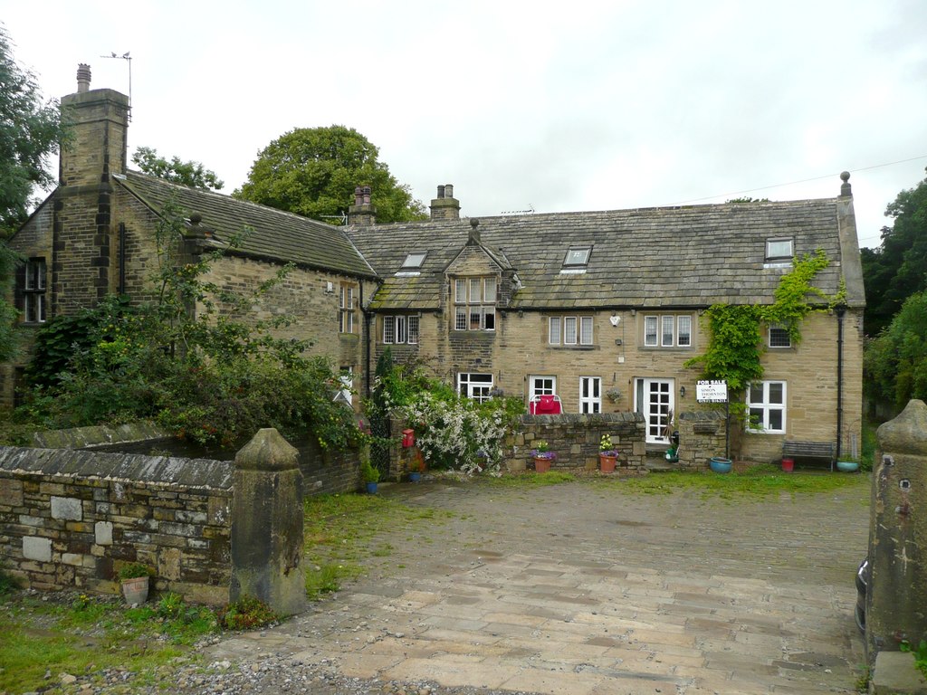
Thornton Hall shown on the 1852 map. An old hall off what we know as Coach Lane. Further details to follow. Thornton Hall is a Grade 2* Listed building. Its listing states: ” Large, square late C17 hall with flat, symmetrical, 3 bay south front without gables. Coursed gritstone with flush quoins. Three-storeys divided by string courses. Parapet with gutter spouts. Stone slate roof with corniced chimneys. Six light chamfered mullion and transom windows on ground and first floor and 5 light on second floor without transoms. Chamfered jamb and heavy linteled doorway in east wall. Interior has been altered. Sundial dated 1774.”
Within the grounds are 2 further Listed structures: Thornton Stocks, grade 2, listing states: “Probably C17 or C18. Consists of 3 monolithic stone blocks, to the left, a short plain stone post, to the right a taller stone post chamfered out at top and bottom – probably used as a whipping post. Between the 2, and slotted into a groove on the inner face of each, the third block is cut at the top to take the legs of 2 people. The top ‘board’ is missing.”
Garden wall with 4 bee boles inset, Grade 2, its Listing states: “Said to be of C17 date. Garden wall approximately 12 ft to 14 ft high and of finely coursed thin sandstone blocks (with wider banding courses at intervals). Stone coping and projecting stone band above a range of 4 bee boles, which form shallow stone lined recesses with triangular headed stone frames, in the lower part of the wall.” (updated 17 March 2023)
Thornton Hall Farm shown on the 1891 map – unnamed. Thornton Hall Farm remained a farm until the late 1990s see photograph, when the farmhouse and outbuildings were converted to dwellings. Photograph taken in 2010 when the farm was up for sale. (Updated 28 April 2023)
Thornton Hall Farm
© Copyright Humphrey Bolton and licensed for reuse under this Creative Commons Licence..
Thornton Heights shown on the 1852 map, a large area of land north of Hill Top Road, as now. See also Back Heights. (Updated 17 March 2023)
Thornton Heights Quarry shown on the 1852 map. A sandstone quarry south of what is now Back Heights Road. (updated 17 Match 2023)
Thornton Heights Delf shown on the 1852 map. Sandstone quarry between Half Acre Road and Hill Top Road. (updated 17 March 2023)
Thornton Joint Hospital, built in 1892. On Back Lane, in 1933 called the Thornton Smallpox Hospital. Now demolished, (updated 28 April 2023)
Thornton Lane End see Keelham
Thornton Mechanics’ Institute started elsewhere in Thornton in c.1834. In 1839 it was held in the Kipping Independent School room. 32 years later a new, larger building was built on Market Street where Thornton Community Centre is now. The building included a Lecture Hall with small balcony and seating 500 persons plus a gymnasium, (later converted into a library). Various school and adult classes were also held there. Its foundation stone was laid on 2nd July 1870 by Joseph Craven and the Institute building completed in 1871. Joseph Craven gave the land and a third of the cost of the building. The building can be seen in the film of the history of Thornton Grammar School at 1:57 to 2:21. In later years the building was converted to a cinema. Its last film was shown in January 1958. The building was demolished in 1962. (Updated 17 March 2023)
Thornton Mills (Worsted), Called New Mills on the 1852 map, and developed by Simeon Townend, who had previously run the first mill in Thornton, called Low Mill, which was on the site of Hugill Street. The the mills were later called Thornton Mills, and were owned by Theophilus Peel, in partnership with Simeon’s son, George Townend. In 1890 to celebrate his marriage Theophilus Peel paid for nearly a thousand of his employees at Thornton and Bradford to have a day out in Morecambe. They travelled on 2 trains. George Townend died in 1891. In 1897 Theo. Peel was made a Baronet in the Jubilee Honours. In the Bradford Daily Telegraph of 16 June 1900 it was reported that “All the hands, (over 300), employed by Messrs. Peel Brother and Co., manufacturers, Thornton Mills, received a letter from Sir Theo Peel, bart., head of the firm, yesterday, stating that owing to ill health, and acting on his doctor’s advice, he was stopping Thornton Mills, on June 30th, inst. He was, however, moving part of the machinery to Globe Mills, Bradford, and promises to employ as many Thornton people as possible.”
The Bradford Daily Telegraph of 11 February 1901 reported: “Thornton Mills to be restarted“, and continued: “Thornton Mills which up to July of last year were run by Messrs Peel Bros., have been purchased by Messrs. Downs, Coulter and Co., of Pudsey and Dudley Hill. It is expected the restarting will find employment for four hundred hands. Messrs., Downs, Coulter and Co., will remove their entire business from Pudsey and Dudley Hill.” The history of the mill is very much the history of the owner’s connection to the mill. The is now a page on the first owner, Simon Townend.
Press / click on the green, underlined name, to see the story of his life. (updated 20 April 2024)
Thornton Quarries on the 1891 map, in 1852 they were named Thornton Heights Delf. On the 1921 map they were marked “disused” . (Updated 18 March 2023)
Thornton Road is a relatively new road. Indeed it was called New Road up until the 1920s. It didn’t exist up to Leaventhorpe Hall from Bradford until 1826, and from there to the Halifax to Keighley Road until 1829. The is much to write about Thornton Road, but for now one more snippet of information. The eastern boundary of Thornton Civil parish is where Pitty Beck goes under Thornton Road. On the wall there by the large house and grounds is a plaque stating that the bridge and road were officially opened on 30th May 1923 by the Duke of York. The Halifax Evening Courier gave the itinery of the Prince’s visit to Bradford. Part of it states: “2.35pm. The Prince will leave Alston Works for Black Dyke Mills, Queensbury (John Foster and Sons Ltd), proceeding via Thornton Road, Thornton, Brighouse and Denholme Road, Mountain and Queensbury. (En route the new road extending from Fairweather Green to School Green, Thornton, which has been constructed by unemployed ex-Servicemen, will be declared open by the Prince.) It was reported in the Sheffield Independent on 31 May 1923 that “Before leaving Bradford the Prince formally opened the new road constructed by unemployed ex-Service men for improving the main road between Bradford and Thornton by widening it and eliminating two awkward elbow bends. The Prince drove along the new section, which is a very fine piece of work, and highly commended the dual purpose served by it.” Listed buildings on Thornton Road are, from te eastern boundary of Thornton civil parish to the Halifax and Keighley Road, both sides, are:
- Ruins of the chapel of St. James, the Old Bell Chapel. Grade 2.
- St. James Church. Grade 2. List details: “1870 parish church of T.H Healy. A simple but large church of sandstone “brick” with ashlar dressings. Tall nave with shallow cusped lancets to clearstory and low aisles with triple groups of lancets. Rose windows to west and east. Tall south-east tower with plain quoin buttresses to bell stage, strings, false machicolation and broached stone spire. The tower is a prominent landmark on the Thornton hillside. Large interior with south aisle arcade. Font of 1679 from the old chapel, with small octagonal bowl. The east window has late Morris and Co stained glass.”
- 283 Thornton Road, Grade 2. List entry states “Circa 1831 house associated with the nearby Prospect Mill. Two-storeys to road, 3 to rear. Sandstone “brick”. Moulded eaves to hipped stone slate roof. Corniced chimneys. Three bay front with plain C19 sashes revealed in plain painted squared surrounds. Pilastered doorway with frieze and cornice. Included for group value.”.
- 285 and 287. Grade 2. Listing states “No 287 dated 1831. Pair of houses associated with Prospect Mill. May only be an adaptation of a former mill building. The front elevation is symmetrical with 5 bays and 2 doorways to centre. Painted sandstone “brick”, 2-storeys to road 3 to rear. Stone slate roof with corniced chimneys, moulded eaves cornice. Plain squared surrounds to revealed C19 sash windows. Doorways have architrave surrounds with corner blocks. The frieze to that of No 287 has date and incised ornament. Projecting cornices over doorways. The 3-storey rear elevation has stair turrets with narrow round-headed lights.”
- 420, grade 2. Listing states “Circa 1830 small detached house set back from road in garden. Two-storeys, sandstone “brick” raised on basement. First floor sill band. Moulded eaves cornice to hipped stone slate roof. Three bay symmetrical front, the windows plain sashes revealed in squared surrounds. Doorway, approached by flight of steps, has squared jambs and shaped consoles supporting moulded cornice. The frieze has incised diamond pattern.”
- 470-482, grade 2. Listing states “Circa 1830-40 three-storey row with bevelled corner and return to Kipping Lane. Sandstone “brick”. Hipped stone slate roof with moulded eaves; corniced chimneys. Single and 2 light square mullion windows in squared surrounds. Doorways in squared jambs with console brackets to shallow cornices. Friezes decorated with incised geometric patterns. Pilastered shop windows to both fronts of No 482 with doorway on corner. Important corner site.”
- 379A and 381, grade 2. The listing includes 3, 5 and 9 Priestley Street, and to 2 Friendly Street. The listing states “Includes Nos 379A and 381 Thornton Road. Early C19 cottage row stepped down hill and increasing from 2 to 3 -storeys with slope. Back to back with Nos 2 to 10 (even) Friendly Street and part of the same development which includes South Square dated 1832, sandstone “brick”, stone slate roof, corniced chimneys. Single and 2 light square mullion windows in squared surrounds. Squared jamb doorways. The former No 1 shares south gable end return with No 2 Friendly Street. The hipped roof end facing Thornton Road (No 381) comprises 2 former 2 bay fronts with console corniced doorways, balancing No 373 Thornton Road on corner of South Square. Included for group value.”
- 1189-95 and 1 and 3 Brighouse and Denholme Road, all Grade 2. The listing states “Includes Nos 1 and 3 Brighouse and Denholme Road. Circa 1800-20 block of cottages. Two-storeys, sandstone “brick”. Stone slate roofs with pairs of spaced dentil brackets to eaves. Saddlestones with prominent kneelers projecting over eaves. Corniced chimneys. Single and 3 light square mullion windows in squared surrounds. No 1195 has a deep but narrow 2-storey canted stone bay window with square mullions dividing lights. Squared jamb doorways. The return front to Brighouse/Denholme Road is similar. No 3 has a circa 1840-50 corniced doorway.”
- 1366, 1368, and 1370, plus 7 and 8 Keelham. The Listing can be seen here. (Updated 19 March 2023)
Thornton Road (1891) Now named. For further details of all dwellings and other buildings on Market Street see “Thornton Thoroughfares” which is a new edition of two former books by local historian Michael Smith (one on Market Street and the other on Thornton Road). Thornton Thoroughfares is published by Thornton Antiquarian Society. The book may be borrowed from Bradford Libraries.
Thornton Smallpox Hospital on the 1933 map had previously been named Thornton Joint Hospital. (updated 18 March 2023)
Thornton Station on the 1891 map but built before, on a man-made embankment, between Woodsley House and Ashfield Street. In 1891 there were very few houses near the station on Thornton Road. (Updated 18 March 2023)
Thornton Station Goods Shed and yard on the 1891 map, built earlier around 18777/8 on a man-made embankment between Thornton Station and Old Mill. (Updated 20 March 2023)
Thornton Viaduct: On the 1891 map. Thornton Viaduct named on the O.S. map. It can be seen from Low Lane, Clayton and Alderscholes Lane, but not from Thornton Road. Click on the Green heading above for full details. (Updated 18 March 2023)
Thornton War Memorial and War Graves: The War Memorial is accessible both from the main (western), and eastern, entrances to the Cemetery, on the internal road/pathway on the southern edge of the cemetery by the main Thornton Road. The memorial was erected by the people of Thornton and unveiled and dedicated on 30th September 1922. The memorial lists 142 Thornton men who were killed in the !st. World War, and 33 who were killed in the 2nd World War. In addition there are 17 men listed by the Commonwealth War Graves Commission buried in Thornton Cemetery and 2 in the Bell Chapel churchyard. Details of those commemorated are here. Details of those remembered on other war memorials in Thornton are listed from here. The War Memorial is a Grade 2 Listed structure. The listing states “Thornton War Memorial, which stands in Thornton Cemetery, is listed at Grade II for the following principal reasons: * Historic interest: as an eloquent witness to the tragic impact of world events on this local community, and the sacrifice it has made in the conflicts of the C20; * Architectural interest: the substantial Yorkshire stone structure is the perfect foil to the sculptural elements; * Sculptural interest: for the well-sculpted life-sized figure of Sorrowing Victory by Harold Brownsword ARCA.” (Updated 19 March 2023)
Thorpe Avenue is on the 1947 map, off Thorpe Road. (Updated 18 March 2023)
Thorpe Grove is shown on the 1947 map, and the 1939 Register. It is a cul-de-sac off Thorpe Road (Updated 18 March 2023)
Thorpe Road On the 1947 map. the beginnings of Thorpe Road are shown as built as far as Thorpe Avenue, including Thorpe Grove. Thorpe Road from Thornton Road. (Updated 18 March 2023)
Throstle Nest, in the 1841 census, given as “Pinch Beck or Throstle Nest”. Shown on the 1852 map. A throstle is a song-thrush. An area to the north west of Pinch Beck. (Updated 16 August 2023)
Top of the Garden see Garden Top
Top of the Row On the 1852 map aome dwellings between Thornton Road and Well Heads, east of Keelham.
Torenton The name of Thornton in the Domesday Book in 1086.
Town Bottom in the 1851 census, the area called Town End in the 1841 census. (Updated 9 September 2023)
Townend In the 1841 Census. The start of what is now Market Street at its east end. The first person listed in 1841 is John Fawthrop, a Surgeon. The area at the start of Market Street in 1861 was Fawthrope’s Buildings where Widow Fawthrop lived in the 1849 Tithe award, and in 1871 was the Fawthrop Hotel (and Union Hotel). (Updated 20 February 2023)
Townend, Simeon, 1803 – 1860, Click / press on the dark green, underlined heading for more details of his life. (Updated 12 April 2024)
Tramway is shown on the 1905 map. From Bradford to just past Vine Terrace. Bradford Museums have a photograph of the first tram to arrive in Thornton in October 1900. J Stanley King wrote a pamphlet on the tramway – Development of the Thornton tramway, 1919 to 1931. Once I’ve read it more information will appear here. Trams from Four Lane Ends to Thornton started on 18 December 1900 and finished on 20 November 1934. There was a separate tram from Four Lane Ends to Bradford from 20 December 1900 to 20 November 1934. (Updated 12 April 2023)
Trash Hall in the 1861 census. Partway up the lane, off the Brighouse and Denholme Road, in the current civil parish of Thornton, which leads to Upper Shay Farm. (updated 18 August 2023)
Travis House is shown on the 1852 map, on the Brighouse and Denholme Road near to an old pit. It is in that part of Thornton which was transferred to Queensbury civil parish in the year 2004. (updated 17 August 2023)
Trolley Buses started on 21 November 1934 and ended on 26 March 1972. There were turning circles at both Bell Dean Road and Springhead Road as well as at the terminus near to Thornton Cemetery. The cross city service to Thornbury began on14 March 1965 and finished on 26 March 1972. Updated 12 April 2023)
Union Hotel in the 1871 Census, on Market Street, (then named Main Street). Thought to be near the Fawthrop Inn, Market Street. (Updated 20 February 2023)
Un-named roads with dwellings in Thornton Village On the 1852 map, Kipping Lane, Market Street, Havelock Square, Havelock Street, Fountain Street, Bridge Street, Ball Street, Craven Avenue, Green Lane (Upper), West Lane, junction of West Lane and Hill Top Road, and Hill Top Road (part), Long Row, Thompson Square.
Un-named Inn (1891) on Hill Top Road, south side, where Hill Top Inn is.
Upper Headley in the 1841 census, and shown on the 1852 map, an old hall built in 1589 on Headley Leys Lane. See Headley Lane (Updated 16 August 2023)
Upper Headley Ley in the 1841 Census. See Headley Ley Lane. (updated 16 August 2023)
Upper Heights Road is named on the 1891 map.
Upper Hill Top on the 1891 map, dwellings on Hill Top Road, to the west of other dwellings. A footpath leads south to Albion Mill (On Thornton Road) (Udated 19 March 2023)
Upper Hoyle Ing On the 1852 map: To the north of Grandage Gate, off North Cliffe Lane. On the 1849 Tithe Award map called “Hoyle Ing”, a group of dwellings. Hoyle Ing House is a Grade 2 Listed building. The listing information can be read here. (Updated 19 March 2023)
Upper Kipping On the 1852 map: A house dating from 1670, accessed from an un-named road, which is roughly where the top half of James Street is. In the 1841 Census it was occupied by Simeon Townend, described as a Worsted spinner. He as then aged 37, so born about 1804. to be continued, (Updated 6 January, 2023)
Upper Kipping Close on the west side of West Lane. (Updated 19 March 2023)
Upper Mill was a name given to distinguish it from Lower Mill. On Ordnance Survey maps it was called New Mill, but in the first mill owner’s lifetime it was renamed Thornton Mills (Updated 20 April 2024)
Upper Sandle in the 1851 census, between Sandel and Lane Bottom, a farm of 11 acres. In that part of Thornton which transferred to Queensbury civil parish in the year 2004. (Updated 17 August 2023)
Upper Shaw On the 1849 Tithe Award map, south of New Close on the other side of the Road.
Urinals (1933) 1. Just past the entrance to Hill Top Recreation Ground on the left. 2. Opposite the corner of Reservoir View with Hill Top Road.
Valentine Court From Back Lane, east of the bend going from the Sapgate Road end. (Updated 19 March 2923)
Vicarage Shown on the 1933 map west of St. James’s Church
Victoria Cottage (1891) A house near the top of Sapgate Lane.
Victoria Inn On the 1849 Tithe Award map it is to the north west side of the Thornton Road crossroads at Keelham. The Ordnance Survey map of 1852 shows it in a different part of Keelham which appears to be a draughtsman’s error. In the late 20th century it was named the Copper Kettle before its closure and conversion to a private house. (Updated 21 February 2023)
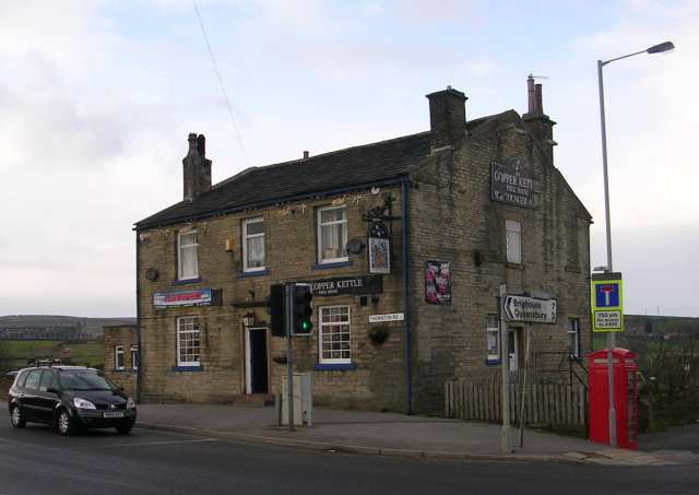
The Copper Kettle – Thornton Road, Keelham
![Creative Commons Licence [Some Rights Reserved]](https://s1.geograph.org.uk/img/somerights20.gif) © Copyright Betty Longbottom and licensed for reuse under this Creative Commons Licence.
© Copyright Betty Longbottom and licensed for reuse under this Creative Commons Licence.
Villette Row, see Gleeson development (updated 12 July 2023)
Vine Terrace On the 1891 map, built with back to backs shared with Providence Row (Updated 19 Mach 2023)
Walks: The website has a page about walks around Thornton, around other parts of the Metropolitan District, and beyond, (In Calderdale and Wycoller, near to Laneshawbridge, Colne. (Updated 7 August 2024)
Wall opposite West Scholes House, Stone troughs set against that wall. These trough are Grade 2 Listed structures. Their Listing states: “C18 or early C19 stone water troughs, one set above the other forming overflow system. Set against dry stone wall.” (Updated 16 September 2023)
The Walls of Jericho (now demolished) These were retaining walls for quarry spoil on the road leading by the original hamlet of Egypt. They became unsafe in 1985 and were demolished during the following months. The road was re-aligned and it re-opened early in 1986. A very good article which was first published in the Bradford Antiquary of 1985 can be read here and a short article in the Telegraph and Argus newspaper here. The T&A contains other articles, too numerous to list, and photographs can be seen on a Google search. No photographs of the walls are shown on this website because of Copyright laws. (Updated 15 June 2021)
Walton Place, built by the Walton family. Now numbers 439-451 Thornton Road. (Updated 26 April 2023)
Warehous Fould, in the 1851 census, thought to be in Mountain, in that part of Thornton which was transferred to Queensbury civil parish in the year 2004. 4 dwellings. In the 1861 census Warehouse Fold is linked with Guy House. (updated 18 August 2023)
Watkin Avenue part of the Thornton Council estate built in the 1920s. Cul-de-sac south of Old Road opposite the former Sacred Heart Roman Catholic Church. Believed to be named after Councillor Christopher Watkin, a Liberal councillor for Thornton and later an Alderman, who served on Bradford Council from 1923 to 1955. (Updated 28 August 2024)
Well Head On the 1852 map, an area of land, south of Well Heads at its eastern end. (Updated 19 March 2023)
Well Heads On the 1891 map, a terrace of houses built on Close Head Lane, which Lane is now named Well Heads. (Updated 19 March 2023)
Well Heads Road On the 1934 map. Previously named Close Head Lane, although the eastern end of this road continued to be called Close Head Lane on maps up to 1947. from Brighouse and Denholme Road to Hill Top Road. Now known as Well Heads. Close Head House and adjoining barn, on Well Heads are Grade 2 listed. Its listing states “Dated 1857. A 2-storey 3 bay villa with service wing, probably a recasing of earlier farmhouse, and incorporating to north-east a barn. Villa designs of this date and type are unusual in the area. Thin sandstone “bricks” with ashlar quoins and dressings. Stone slate roof with moulded eaves cornice. Flanking chimneys with bracketed cornices. Symmetrical south front. Central first floor sash window in rusticated surround, flanking 2-storey pilastered canted bay windows. Pilastered doorway with dated frieze and moulded cornice. Impost moulding to spring of fanlight arch. The set back stone slate roofed barn has segmental archway. Close Head House is prominently set on a terrace overlooking the valley below Thornton.” For Well Heads Congregational Sunday School, see Congregational Sunday School (Updated 27 April 2023)
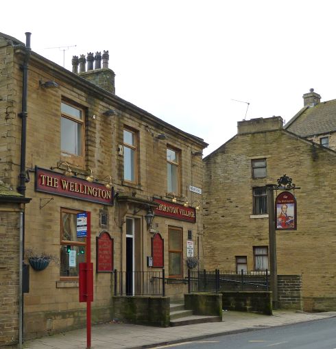
The Wellington public house, Thornton Road. In its heyday. Now closed. Planning applications for conversions to 2 or more shops have been refused due to the desired changes to the exterior of the building by the applicants, the building being on the west side of the Thornton Conservation Area. (Updated 14 September, 2021)
© CC-BY-2.0 Flickr images reviewed by FlickreviewR Files uploaded by INeverCry
This image is licensed under the Creative Commons Attribution 2.0 Generic license.
Wembley Avenue is part of the 1920s built Thornton Council estate. It is a cul-de-sac north of Springhead Road. (Updated 19 March 2023)
Wensley Bank first appears in the 1901 Census. On the east side are “through” houses in a terrace, on the west side are back-to-backs shared with Wensley Bank (West). From Thornton Road, west of Royd Street. (Updated 19 March 2023)
Wensley Bank Terrace is off Wensley Bank West. The south side gives access to the backs of houses on Thornton Road, on the north side are a few houses / bungalows, which appear to have been built after 1939. (Updated 19 March 2023)
Wensley Bank West is shown on the 1905 map. The road appears in censuses from 1911. It runs northwards from Thornton Road, west of Wensley Bank, with which it shares back-to-backs on its east side. On its west side are “through” houses. (Updated 19 March 2023)
West House on the 1852 map, a house to the north west of Spring Hall, opposite a footpath leading from West Lane to Thornton Road.
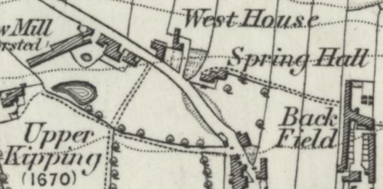
West Lane is shown, unnamed on the 1852 map. consisting of a chapel and mills, plus West House and Spring Hall and Black Horse Yard. West Lane was a main road from Main Street (now called Market Street), to Hill Top and Spring Holes Lane. After its junction with James Street it joins the bottom of Hill Top Road before turning up the hill past its junctions with Lyon Street and Wicken Lane to its junction with Spring Holes Lane. On the north and west sides from its junction with Hill Top Lane, to its junction with Lyon Street it is called Roundfield Place. The Wesleyan Bethesda Chapel was built in 1824. In the 1841 Census there were 4 families living at Pinfold which was near to West House and Spring Hall. The houses on the right hand side, going up the hill were built around 1964/5. in history:
- 1841 Census, West Lane is not mentioned by name. but the following existed. The Black Horse and Black Horse Yard, dwelling to the north of the Inn, now demolished. At the inn was James Driver and family, an there were 12 other unnumbered dwellings, Also on West Lane was Pinfold, where 4 families lived. At Spring Hall Joseph Ackroyde lived with his wife and 7 children. He was a Farmer. At West House there was John Johnson, a waggoner, and his wife plus 7 children, and 2 other families, including David Wright who had formerly owned Low Mill, prior to him having to satisfy his creditors by releasing the mill to his son-in-law, Simeon Townend, and selling of houses and land. Upper Mill was the home of Simeon Townend, Worsted spinner, his wife and family and 6 other families. At the Methodist Chapel one family lived, John and Mary Craven both aged 35 and their 9 children.
- 1851 census doen’t list where the first 14 families listed live, but now adds to the Black Horse, Black Horse Fold, and the Bull’s Head Inn. Upper Kipping now has 4 families living in it, Simeon Townend, then described as a Worsted Spinner and Manufacturer, at that point employed 80 boys, 110 girls, 349 men and 216 women. Most of these were employed at Upper Mill which was built for him in 1837. There’s a West Cottage, but no West House, neither is there Spring Hall. As well as A Chapel House, occupied by the same occupants as given at Methodist Chapel in the 1841 census, there’s now a Preacher’s House, occupied by John Ward a Wesleyan Preacher, Selina his wife and 3 children, John Northrop, a visitor and woolcomber, and 2 servants, one aged 26, and another, apparently unrelated, aged 11. (to be continued, last updated 17 May 2025)
West Scholes in Thornton civil parish until the year 2004; now in Queensbury civil parish. (Updated 15 August 2023)
West Scholes Gate name given to West Scholes in the 1841 Census. Also shown as one dwelling in the 1851 and 1861 censuses. (Updated 18 August 2023)
West Scholes Gate Inn in the 1841 Census. Thought to be a former name of the Junction Inn and Kitchen. In Thornton civil parish until the year 2004, now in Queensbury civil parish. (Updated 15 August 2023)
West Scholes House, shown on the 1852 map, dates from 1694. The house and barn are Grade 2* Listed buildings. The Listing states: “Dated 1694, a fine late C17 house on rectangular plain with irregular 5 bay front, the left hand bay breaking forward. Coursed gritstone with large quoins. Stone slate roof with late C18 corniced chimneys. The roof is extended down over break. Saddlestones, kneelers to rear. Chamfered mullion windows of 2, 4, 5, 6 and 7 lights, drip moulds on ground floor. The hall window, of 7 lights, is to the left hand of the main entrance as at Headley Hall. There is an oval window over the porch and a similar one at first floor level to return of break to main block. Deep, contemporary, gritstone porch with flush quoins, saddlestones and kneelers to gable containing dovecote and panel inscribed W H: I H over date 1694. Extending at angle to right hand and bounding east sills of paved yard is a single-storey wing formerly serving as bier. Coursed gritstone with flush quoins, stone slate roof carried out to form covered way with stone slab piers.” See also Wall opposite West Scholes House, Stone troughs set against that wall. (Updated 16 September 2023)

West Scholes Lane, numbers 51 and 52 are Listed Buildings. Their Listing states: “Pair of cottages built as one house circa 1800-20. Two-storeys, sandstone “brick” with flush quoins. Stone slate roof with saddlestones and prominent kneelers. Three bay front with 3 light square mullion windows flanking central 2 light windows. Some alterations to No 51. Modern gabled joint porch. No 52 has wing with 2 light square mullion window. Similar window in west gable end.” (Updated 16 September 2023)
Westfield House is shown on the 1852 map, being a house at the top of Chat Hill, opposite Ox Hey’s. (Updated 19March 2023)
Westville Way from West Lane, westwards, an un-adopted road serving 4 properties, plus Ladyfield, and Chapel Terrace. (Updated 19 March 2023)
White Horse Inn shown on the 1891 map. with a terrace of dwellings, west of the Sunday School on the opposite side of Close Head Lane (now Well Heads). It is now in Denholme Parish but has a Thornton address. The photograph was taken in 2008.
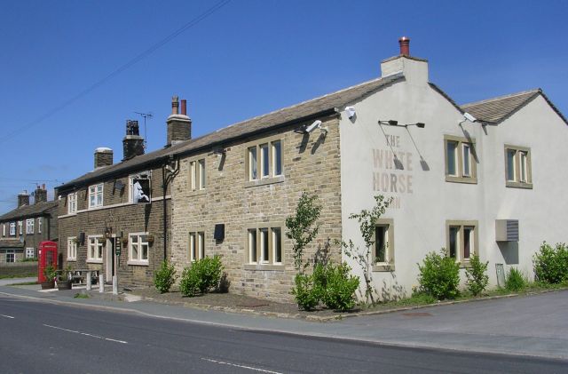
© Copyright Betty Longbottom and licensed for reuse under this Creative Commons Licence.
Who could have thought it shown on the 1852 map, and in the 1841 Census as “Thought it”. Not clear on the map whether it was a terrace of dwellings on what is now Cliffe Lane at the junction with Sap Gate Lane, or the land opposite the terrace. On the Tithe Award map, called “Who’d have thought it”. Origin not known, but on that area of Cliffe Lane which gives views of Bradford. Though it wasn’t a field name in the 1849 Tithe Award, it may have been earlier. Paul Cavill’s “A new dictionary of English field-names”, published by the Placename Society in 2019 gives the following definition: “An expression, (also used as an inn name in some places), pretending surprise at the productivity of the field, or even at the field being there at al.” (Updated 25 June 2023)
The Wicken is shown on the 1852 map as The Wicking. A field between Long Row and Wicken Lane. (Updated 19 March 2023)
Wicken Lane first appeared in the 1861 Census. It runs from Hill Top Road to the top of West Lane, as now. (Updated 19 March 2023)
Willcock, in the 1841 census, off Pit Lane. A farm, was part of Thornton civil parish until May in the year 2004, when it was transferred to Queensbury civil parish. (Updated 16 August 2023)
Willcock Lane End, in the 1841 census, off Pit Lane. It was part of Thornton civil parish until May in the year 2004, when it was transferred to Queensbury civil parish. On the 1893 map Wilcock Lane End is shown as Lee Top. (Updated 16 August 2023)
William Street is referred to in a land-sale notice in the Bradford Observer of 11 January 1866, viz., “Lots 38, 39, 40, and 41. Four plots of building land, two of which have double frontages. The contents, including one-half of so much as Firth, William, and James Streets as are co-extensive therewith, are 659, 433, 433, and 994 square yards respectively.” James Street, as we know it, didn’t exist until 1869/70. I suspect the James and William Streets mentioned became Mary and Peel Streets. (Updated 20 June 2023)
Windsor Grove is on the 1947 map, and in the 1939 national Register. It is a cul-de-sac from King Edward Terrace on the western side. (Updated 19 March 2023)
Wold Close A cul-de-sac west of Albert Street. Housing on the north side, possibly 1960s or 1970s. (Updated 19 March, 2023)
Wood Manywells shown on the 1852 map, a dwelling east of Ten Yards Lane north west of Moor Cock.
Woodlands built for Mr. Simeon Townend, who built what became Thornton Mills on West Lane. Date of building not known, though it existed in 1865. Later, it was the residence of Mr. J. W. Downs , of Downs, Coulter, textile manufacturers, from about 1902. It was on the south of Thornton Mills. Vandalised and set alight by unknown arsonist in the early years of this century. (Updated 22 March 2023)
Woodlands Close a cul-de-sac eastwards from James Street. On the north side a remaining section of Down, Coulters Mill which has been converted to “town houses”, on sale in 2023. (Updated 20 March 2023)
Woodsley shown on the 1891 map. A house on Thornton Road, east of Thornton Colliery. (Updated 20 March 2023)
Woodsley Fold from Thornton Road, opposite the east end of the cemetery, named after Woodsley, a house which had previously been demolished. (Updated 20 March 2023)
World’s End on the 1852 map, a dwelling south of Bell Dean, accessed by a road from Hobb End. Now World’s End Farm (Updated 20 March 2023)
World’s EndView A cul-de-sac of houses, relatively modern. (Updated 20 March 2023)
Wuthering Heights, see Gleeson development. (updated 12 July 2023)
Wyndy Ridge A short cul-de-sac southwards from Hill Top starting alongside the Hill Top public house. (Updated 20 March 2023)
Yew Farm on the 1891 map. A dwelling south of Thornton Road and east of Chat Hill, just south of School Green junction (Updated 20 March 2023)
Yews Green Head appears in the 1851 census, in that part of Thornton, near West Scholes, which was transferred to Queensbury civil parish in the year 2004. (updated 17 August 2023)
