For other places, etc., click / press on the appropriate button
All links are in dark green.
List of places, etc., starting A-D
Ackroyd Court From Market Street, behind what was Kipping School, but now leading towards relatively new social housing for older people, (off Fountain Street). Listed buildings 2 to 4, dated about 1840. In Thornton Conservation Area. (Updated 22 April 2023)
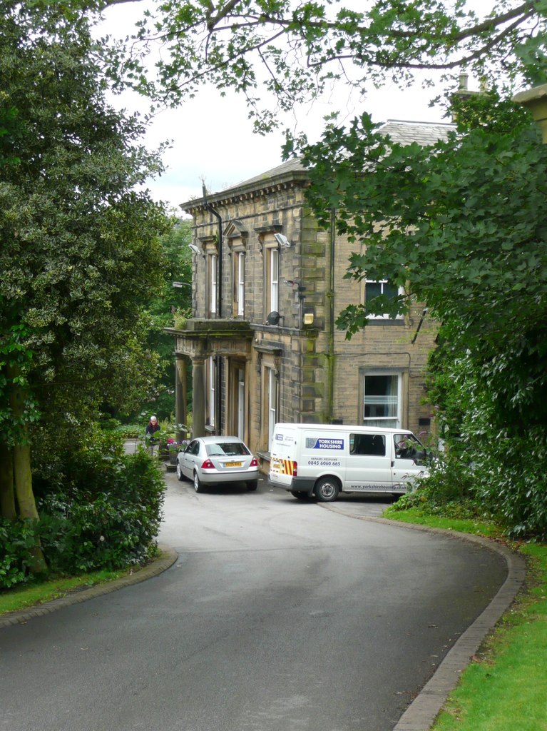
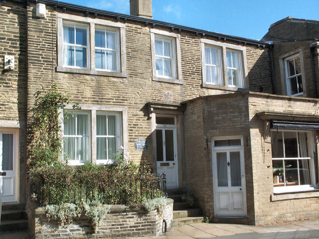
Agnes Grey Lane, BD13 3BW, contains numbers 3, 5, 7, and 9. See the map below Anne Brontë Avenue (Updated 19 September 2025)
Alan Court Built on the former Bowling Green on the south side of the New Inn. Named after the developer’s father. The bowling green was used in the 1920s and probably later. In Thornton Conservation Area. (Updated 22 April 2023)
Albert Street Census returns for Albert Street begin in 1871, From Market Street, northwards Mainly back to backs, part of the west side not yet built upon. At the top a detached house at right angles to the road, i.e. looking down the road. In February 1882 at the Local Board meeting, “A letter was read relative to the filthy condition of Albert Street, and it was decided to notice (ie. to notify) the various owners to pave, flag, etc., the street, and put it into proper condition, failing which the Board would do the work, and charge the cost to the owners.” Albert Street is most likely named after Albert, Queen Victoria’s consort, who died at the age of 42, and was deeply mourned by Victoria. (Updated 12 April 2023)
Albion Mill (Woollen) On the 1908 map it was named. On Thornton Road between Albion Place and the Cemetery. During the time of the first World War the mill was owned by Mr. Alfred Northrop, who lived at some time with his wife, Julia, and sons at Thornton Hall.. The mill was on land adjoining the east of Thornton Cemetery. It was demolished sometime around the mid 1970s (Updated 22 April 2023)
Albion Place First appears in a report of the proceedings of the Local Board of Health, in the Bradford Observer of 14 February 1882, when “A plan for the erection of a villa residence at Albion Place was referred to the Buildings Committee.” That residence was subsequently built for the owner of Albion Mill, Mr. Alfred Northrop, his wife Julia and son. It was called Field Head House. Albion Place first appears in census returns in 1891. A mill and 2 rows of back-to-back dwellings plus the detached house and garden. On Thornton Road east of Albion Mill. (Updated 12 April 2023)
Alderscholes On the 1852 map. Buildings to the north of Alderscholes Lane and opposite Green Clough. See also Alderscholes Lane. (Updated 28 June 2023)
Alderscholes Close From Alderscholes Lane. Built around the year 2000. (Updated 28 June 2023)
Alderscholes Lane The Lane runs from Lower Kipping Lane to Squirrel. Listed Buildings include numbers 2 to 22 (Pinchbeck), dated about 1830; 21 to 29 dated about 1830; 24 to 30 dated about 1800 to 1820; 36 to 40, dated about 1830; 42 and 44, dated about 1800, and 46, 48 and 50, dated about 1830 to 1850; as well as Highfields Farmhouse and Integral Barn, dated as Late 18th Century; and Thornton Railway Viaduct, dated 1876 to 1878.
- Alderscholes Lane in the news: 1841, 14th August, an advertisement in the Leeds Intelligencer for an auction of various Lots in Thornton. Lot 11 was for a Farmhouse called Alderscholes, with a cottage, barn and outbuildings, and 6 closes of land, called the Laith Close, the Stavers, the Cross Lands, the Lower End of Long Hatts, the Lower Field, and Midgholes, containing approximately 20 days’ work, and occupied by Mr. Joseph Illingworth.
- 1846 19 November. A report in the Bradford Observer of the accidental death of a boy called Jonas Robinson, aged about 12, who died in a coal-pit by a stone falling on him from the roof of one of the gates in the said pit.
- 1852. 31st July, a report in the Yorkshire Gazette, of a “melancholy experience”, when Mr Charles Frederick Bailey, a druggist, aged about 23, went out with a friend to enjoy an hour’s shooting. He was in a field near Alderscholes, where there had been a coal-pit, and in that field there was also a vent-shaft which he didn’t know about, and which was not fenced off, but covered with brush, grass etc. Keeping his eye on the bird he was shooting at he walked and fell down the shaft to a depth of 40 yards. When he had been recovered from the shaft, and examined by both Dr. Corrie and Dr. Hill “he was so much injured… that life was quite extinct.”
- 1863, 7th February in the Leeds Intelligencer, various farms to let, including Highfield Farm at Alderscholes, containing 12acres, 3 roods and 35perches, “now or late in the occupation of Joseph Ackroyd.”
- 1869, 15th July. The Thornton Local Board approved plans for the erection of chemical works, warehouse and stables, at Alderscholes, by Mr. Watson.
- 1875, 10th September in the Bradford Observer a report of a thunderstorm which hit Thornton. “The lightning was very vivid, and the flashes followed one another in quick succession, while the rain poured down in torrents. During the storm, a stone wall, four feet high, separating two large fields adjoining Alderscholes Lane, were struck by lightning and a portion about two yards in length was knocked down.” “It appears that a widow, named Elizabeth Sharp, 60 years of age of number 8, observed what appeared to be a large cloud of fire descend upon the wall, about 110 yards from her residence, and immediately a loud report was heard, and the wall fell. The report shook the ground for some distance, and Mrs. Sharp, as well as those who lived in adjoining houses, distinctly felt the buildings tremble, and some of them were much terrified.”
- In a Directory of Collieries in 1883, Edward Clayton owned Alderscholes colliery.
- In 1916 a sad report, in the Bradford Daily Telegraph of 28 November, of Mr. Harry Dean of Alderscholes, Thornton who was seeking information about his brother, Private Willie Dean, who had been officially reported missing since October 12th, aged 29. Willie Dean is remembered on Thornton War Memorial. He was one of many thousands of soldiers whose bodies were never found.
- In 1937 on 5 January, the Bradford Observer reported on the accidental death of William Shuttleworth, aged 12, of 50 Alderscholes Lane, who died as a result of a cycling accident. He was seen lying in the road while his pedal cycle was “sliding down the road” (on an icy surface). The cycle stopped about 25 yards away. The boy was found to be suffering from a cut over the right eye, concussion and severe shock. He was taken by ambulance to the Bradford Royal Infirmary, but died within a few hours.
- In 1941, on 1st November, in the Yorkshire Post and Leeds Intelligencer Harold Ambler of Alderscholes Farm requested about 10-20 tons of good sound Pig Potatoes: state price, deivered to farm or to Thornton Station.
- Less than 3 years later he was selling his farm stock as his son had enlisted in the forces. (updated 19 October 2023).
Ale houses: There will be an entry for each Public House, (including ale-houses, inns, taverns, and hotels). A list of all known are found under the heading Public Houses. (Updated 20 February 2023)
Allen Park Farm On the 1893 map, on Ten Yards Lane. A farm north of Moor Cock Farms.
Allerton Lane From School Green northwards to Pitty Beck (in Thornton civil parish). The Lane then continues to Allerton. Numbers 5 to 11 Allerton Lane are Listed Buildings dating from about 1820 to 1830. Lower Hoyle Farm is also a Grade 2 listed building.
Allerton View a cul-de-sac from Old Road, northwards.
Allotment Gardens in 1921 1 Hill Top Road, south side and westwards almost to opposite Long Row. On the road to un-named Edge House Farm. 2. On two parts of the disused Storr Heights quarries, where Oak Hall Park now is. 3. Between the north part of Havelock Street and Spring Gardens on Sapgate Lane. 4. Below 3, between the south part of Havelock Street and Sapgate Lane, where Sapgate Gardens is now. 5. Between Havelock Street and Back Field, where a bungalow and three houses now are. 6. Between the south side of what is now Enderley Street and Pinch Beck. 7. North of Peel Street, below Upper Kipping. 8. West of Peel Street to James Street. 9. East of Royds Street. 10. North of Royds Street. 11. South of Alderscholes Lane, south-west of Pinch Beck dwellings. 12 On the north-east side of Cliffe Lane. 13. On the north-east side of Old Road, just near the junction with Thornton Road. Nearest buildings were at Bricks.
Allotment Gardens in 1933 1. North of Royds Street to what is now the Brontë Way, the footpath leading west from the end of Reservoir View. 2. South of the then disused Storr Heights Quarries. 3. North of Back Field. 4. Between the west side of Ball Street and the east side of Bridge Street. 5. South of what was previously named Thornton Sewage Works, to the west of Green Lane.
Alpine Rise from West Lane to Harcourt Avenue. Built in the 1970s. (Updated 28 June 2023)
Anne Brontë Avenue, see the map below. (updated 9 December 2024)

Appleton Court off John Street. Built about 1986. Named after Norman Appleton, the builder, who lived in Hatched Black Cottage. (Updated 28 June 2023)
Ash Tree Avenue Built around 1966. A cul-de-sac from Close Head Drive.
Ash Tree Farm Shown on the 1893 map. A farm to the south west of the lane leading from Hill Top Road to Bottom of the Row.
Ash Tree Hotel Shown on the 1893 map almost opposite Ash Tree Shed, the hotel being where Ashtree House B&B now is. Between the Hotel and the B&B it was a private house for many decades.
Ash Tree Shed (Worsted) Shown on the 1893 map, The owner in 1901 was Mr. Riley Farnell. He was declared bankrupt early in 1901, and around 22 March he was found dead, in the mill dam. He was known to have been a very hard-working man who lived at 2 Vine Terrace.
A report of a weekend break-in, in the Bradford Daily Telegraph of 10 October, 1904, shows that the mill was at that time known as Excelsior Mills, and was run by John Bentley & Co., waterproof cloth manufactuters. Located where Simmonites now are on Thornton Road. (Updated 16 June 2023)
Ashfield House, and extensive gardens built about 1850 to 1860 for the Craven family, Grade II Listed Building. On the 1893 map west of Green Lane (lower section), south of Thornton Road, and east of Prospect Street. On the 1933 map it is shown as a Mental Hospital run by Bradford Corporation. Later it became a care home owned by the Brunel Housing Association, registered for care for people with learning disabilities. The photograph was taken in 2010.It is now a private house and flats. Ashfield House was the home of Joseph Craven. Born on 14 December 1825, he was the elder son of Joshua and Ann (Briggs) Craven of Close Head in Thornton, near Bradford, Yorkshire. In 1852 he and his father transferred from hand loom weaving to production at Thornton’s Prospect Mill, of which Craven had laid the foundation stone on his twenty-first birthday and where 300 looms and 420 employees were busy by 1851. In that year the Cravens displayed examples of their plain-backs and shalloons at the Great Exhibition, and in 1854 they added spinning to their weaving operation, more than doubling the size of Prospect Mill. His father retired in 1862 and died in 1874. Six days later Joseph Craven’s only son, who had joined the family business and was “in the bloom of youth and full of promise”, also died. The double bereavement sent Craven into temporary decline and in 1875 he sold the business, which was then employing between 500 and 600 people. His wife died in the following year and he remained a widower for nearly four decades, continuing to live at Ashfield, the Italianate villa he had built overlooking Prospect Mill. He was Liberal MP for Shipley from1885-1892, when Thornton was in Shipley constituency. (Updated 28 June 2023)
© Copyright Humphrey Bolton and licensed for reuse under this Creative Commons Licence.
Ashfield Inn in the 1871 Census at 52 New Road, (now known as 490 Thornton Road). In Jauary 1869, and in 1871 the Inn Keeper was Joseph Thwaites. (Updated 16 June 2023)
Ashfield Road appears to have been built over a period of years. Houses numbered 1-17 are in a different style to those from 19 to 27. On the evens side there are some much newer dwellings, probably post WW2, as well as two older dwellings. The 1893 map gives the name Ashfield Street, which could have been an error. In the Christian Advocate of 4 March 1892 there’s an article on Magnetism by the Revd. Charles Crougher of 9 Ashfield Road, Thornton. A newspaper article in the Leeds Mercury of 15 July 1895 refers to the death taking place on Sunday 14 July of the Reverend John Corrigan, B.A., curate at St. James Church, aged 40. He left a widow and 4 children. The first “odd numbered” houses are back to backs with Rock Terrace. Census returns for 1891 show 3 dwellings, for 1901 11 dwellings, for 1911 20 dwellings, and for 1921 19 dwellings. In the 1939 Register there are houses 1-27 plus 12 and 14. (Updated 23 April 2023)
(The) Athenæum see Commercial Street
Back Field Back Field has its vehicle entrance off Market Street. There are many Grade II Listed properties on Back Field: Numbers 1 to 13, dated around 1820; 15, 17, 22 and 24, dated about 1820; and 19 to 29 (odd), dated about 1820. On the 1852 map Back Field was built on a field named in the Tithe Award and Map as Back Field. The cottage which goes over the road access to upper Back Field used to be Feather’s Sweet factory. See photos. There were 20 households in Back Field in the 1841 Census. House numbering did not come ino existence until many years after 1841. The 1841 Census also lists residents of Swine Market, Back Field, and Ginnel Bottom where lived Jonas Holdsworth a Beer seller, aged 33. There are also two dwellings at Ginnel Top in 1841. (Updated 19 March 2026 – link to Tithe Award maps changed)

cc-by-sa/2.0 – © Betty Longbottom – geograph.org.uk/p/1577588

Back Heights On the 1893 map there were many houses at right angles to what is now called Half Acre Road, opposite Low Fold Farm. (more houses than now). (Updated 16 June 2023)
Back High Street accessed from High Street, and from steps leading from Market Street to the west side of what is now Manzil’s, but was Barracloughs. (Updated 27 June 2023)
Back John Street On the 1921 map buildings on Thornton Road previously built, rear street now named.
Back Lane On the 1852 map, in Allerton civil parish. That part of Allerton Road which is between Prune Park Lane and Dean Lane Head, and that continuing from that junction to Wilsden, known as Back Lane today.
Back Lane On the 1893 map, in Thornton, now named. There are a few dwellings to the west of Storr Heights Quarries.
Ball Street was first named on the 1893 map, but is shown on the 1852 map. In the 1841 Census occupants of 15 dwellings are given. The street is south from Market Street to Thornton Road. Mainly back to back housing both sides and 3 courts on the east side, one having access through the large building on the corner of Market Street with Ball Street. That building had a covenant on it to ensure access to the court was maintained. The map from 1893 shows the top two courts, and the entrance to the first court through/under the side of the Market Street building, shown to the right of an arrow which was the only access for the dwelling marked with a green spot. (Map produced with the permission of the National Library of Scotland). The photo shows that (now gated) entrance passage. There would not have been any grass.
On June 20th 1865 the Thornton Board of Health agreed that the temporary water tap which had been attached to the mains at New Road End, Green Lane, and the top and bottom of Ball Street should be opened to the public on the following day, and to remain open a stated time, morning and evening, the charge to be 2p. per week. (Updated 16 June 2023)


Bank On the 1908 map shown on the corner of Lower Kipping and Thornton Road.
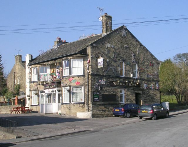
The Barrack(s) Tavern, as at 11 Back Heights Road, in the 1881 Census. It appears to have closed in 1933. (Updated 25 February, 2023)
Baths Built on land on Thornton Road next to the then Grammar School, shown on the 1933 map. When the Thornton Urban District Council agreed to become part of Bradford Corporation in 1899, Bradford Corporation agreed it would build slipper baths for the miners in many mines around the village.
The land for the Baths, an area of 2282 square yards, was sold by J. Ingham and sons, Shuttle makers, in December 1926. At this time most houses did not have bathrooms. In 1931 the Thornton Swimming Baths were opened by the Corporation. They were closed in the winter of 1999, and closed down in 2000, mainly due to lack of maintenance over the years, plus they could not fulfil the needs of the Disability Discrimination Act. Bradford Council sold the baths to a private owner who made them into a commercial gym, which did not last long due to better facilities being available at Thornton Recreation Centre. The former baths have since had two former owners. The most recent was given planning permission on 28 June 2021 to convert the building into 2 dwellings and 9 apartments. The photo was taken in 2007, that is when it was a private house.
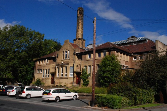
Thornton Road. Former Swimming Baths.
cc-by-sa/2.0 – © Andrew Riley – geograph.org.uk/p/969922
Bay Horse Inn was situated at 381 Thornton Road, (formerly 27 New Road), now occupied by Christophe’s and the de Luca hairdressers. In the 1871 Census it was near Shuttle Street. The Beerseller, (and Tailor) was John Henry Varley in 1871. It is known to have existed in 1909, but had ceased to exist sometime before 1916. (Updated 24 February 2023)
Bede’s Close a cul-de-sac leading eastwards from West Lane, with access to the lower remaining building which was part of Downs, Coulters Mill, plus residences supported by St. John of God Hospitaller services.
Bell Chapel see St. James Church (Perpetual Curacy)
Bell Dean On the 1852 map: An area of moorland, and to the east a tree belt, immediately south of Pitty Beck from Egypt. Origin of the name: Bell from the Old English meaning beautiful; Dean from the Old English meaning a valley.
Bell Dean Quarry On the 1852 map: A sandstone quarry at the western end of Bell Dean, south of Egypt.
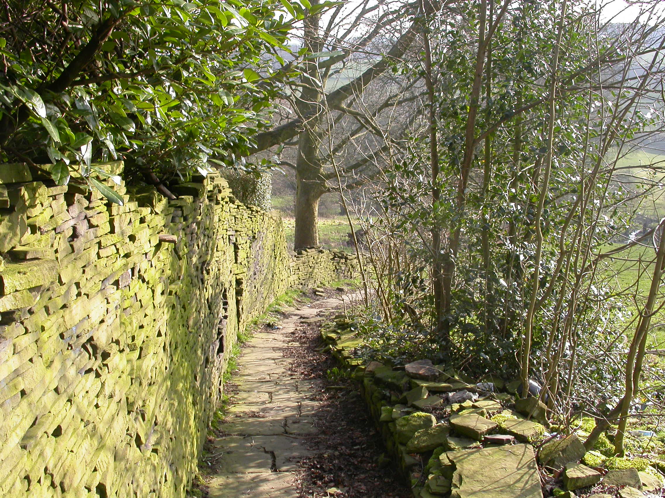
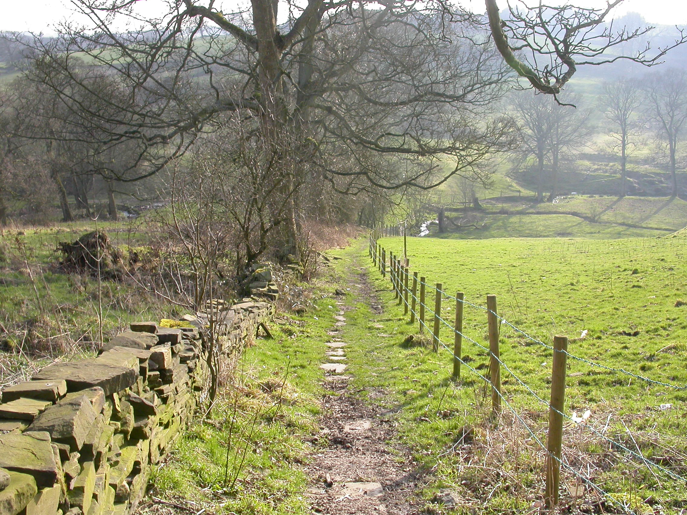
Bent Ing A field name of the local beauty spot on the south side of Pinch Beck accessed by a footpath from Lower Kipping Lane to Headley. The footpath and Bent Ing can be seen in the photographs. The origin of the field name of Bent Ing appears to be an Ing, (a meadow or grassland, especially those near a water-course), which contains a type of grass known to this day as Bentgrass. (updated 25 June 2023)

Bethesda Chapel (Wesleyan) and Burial Ground Wesleyan Methodists formerly rented some cottages on Hill Top in which to worship but by 1824 they had amassed enough capital to build the Wesleyan Chapel which used to stand in West Lane, later known as Bethesda. By 1851 the 1824 building was to be enlarged. At this point there was some dissension and the Wesleyan Reformers broke away from the Bethesda Wesleyans to build their own church. Originally the reformers met in the Athenæum on Commercial Street, but by 1857 they had the land and money to build the Methodist Free Church, where Headrow Court and the Methodist Church now are. The Bethesda Chapel shown on the 1893 map, just below the junction of West Lane and James Street, on West Lane By the 1908 map it has a Sunday School named. In 1872 the Chapel was licensed for weddings. In April 1948 the building was declared unsafe due ti the weight of the roof forcing te 1851 walls to bow out. The 1824 building stayed intact. Services were moved to the Sunday School room. In May 1955 the national Methodist Conference decided to close the Chapel, and sell it for demolition. The last service was on Sunday 11th September 1955.
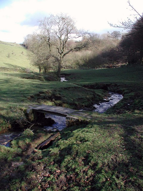
Birks Beck: On the 1852 map: A stream running from halfway down an access lane to Wilcock Royd, off Pit Lane, through Headley Clough and north of High Birks to join into Pinch Beck. One of the walks on the Walks page includes a walk around Birks Beck.
cc-by-sa/2.0 – © Paul Glazzard – geograph.org.uk/p/358732
Birks Fire Clay Works shown on the 1921 map. It was called Clayton Fire Clay Works on the 1893 map. Situated on a short branch line close to the railway where it cuts through High Birks.
Bishop Buildings are on the 1893 map, on Thornton Road to the east of School Green and north of Yew Farm. Bishop Buildings was not on the 1933 map. The Vicar of St. James lived there prior to the Vicarage being built next to the church.
Black Carr On the 1852 map: The land south of Lower and Higher Sandal. Black Carr Farm On the 1893 map On the Brighouse and Denholme Gate Road south west of Higher Sandal, now known as Bar Farm. Black Carr and Black Carr Farm in the news:
- 1793, May 7, Jonas Craven, later textile manufacturer, was born at Black Carr.
- 1804, January 30. The Leeds Intelligencer of that date carries an advertisement on page 3 as follows: To be sold at Auction at the Black Horse Inn in Thornton…Lot 5, “In Thornton, a Freehold farm, called Black Carr, consisting of a Messuage, Barn, Outbuildings and eight closes of land, containing 21 days’ work, or thereabouts, in the occupation of John Robertshaw. This Lot contains coal.”
- 1815, May 20. In the Leeds Mercury, a similar sale “at the house of John Thwaites in Thornton” a sale of Black Carr Farm, containing as before, but reckoned to be 22 days’ work, occupied by John Robertshaw, “supposed to contain coal.”
- 1834, October 2nd. The Bradford Observer reports the death of Jonas Gawthorpe, farmer, aged 72 of Black Carr, Thornton.
- 1839, July 18. The Bradford Observer reports the death of Thomas Crossley, of Black Carr, Thornton, farmer, aged 90.
- 1840, April 18, The Leeds Mercury reported that Mr. Joshua Priestley aged 51, of Black Carr, had died.
- 1840, June 6, The Leeds Mercury reported that Rose, aged 39, wife of Mr. John Brigg, farmer of Black Carr, Thornton, had died.
- (to be continued, updated 26 June 2024)
Black Carr Farm (currently) is the first building along the lane coming off Deep Lane at its lower end , on the left going uphill from Green Clough, the next building is Lower Sandal Farm. (Updated 21 October 2022)
Black Carr Terrace see Clog Street, Black Carr Terrace.
Black Dike On the 1852 map: Land south of Bell Dean Quarry, and east of the Rock and Heifer Inn.
Black Dyke Lane On the 1893 map, following regularisation of spelling, previously Black Dike Lane On the 1852 map: Road running northward from Lower Heights Road towards Hazel Crook End and Old Allen Slack.
Black Dyke Lane Quarry On the 1908 map to the south west of Black Dyke Lane, opposite Egypt Quarry. Now dis-used.
Black Horse Inn at the junction of West Lane with Market Street and Kipping Lane. The photograph as taken in 2010. The Black Horse is shown and named on the 1849 Tithe map. The earliest reference to the Black Horse Inn in newspaper articles is a notice of an auction to take place in the Black Horse of 3 portions of land, in the Leeds Mercury of 16 March 1811. It was common practice to hold auctions and inquests in public houses.
An article in the Bradford Observer of 27 October 1842, refers to a new “court” of the Ancient Sheppardesses being set up at the Black Horse, 12 new members were enrolled, and upwards of 70 members “partook of a substantial dinner, and spent the evening in the greatest cheerfulness and good humour.”
To the north of it were dwellings called Black Horse yard. These dwellings were demolished in the 20th century. Frank Watmough lived at 8 Black Horse Yard. He was killed in action in July 1918 and is remembered on Thornton War Memorial. (Updated 8 June 2023)
© Copyright Betty Longbottom and licensed for reuse under this Creative Commons Licence.
Bloomers, in the 1851 census, between Squirrel Hill and Malt Kiln. Occupied by William Lingard aged 38, a Hand Loom Weaver, his wife and chldren, and Elizabeth Foster a Lodger aged 17, whose ooccupation given is a Par Weaver – thought to be a Power Loom weaver. (updated 17 August 2023)
Blue Boar Public House on Thornton Road at the junction with Green Lane (upper part). The terrace it is at one end of was known as Green Mount in the 1901 and 1911 censuses. Originally the Blue Boar was called the Green Mount Inn.
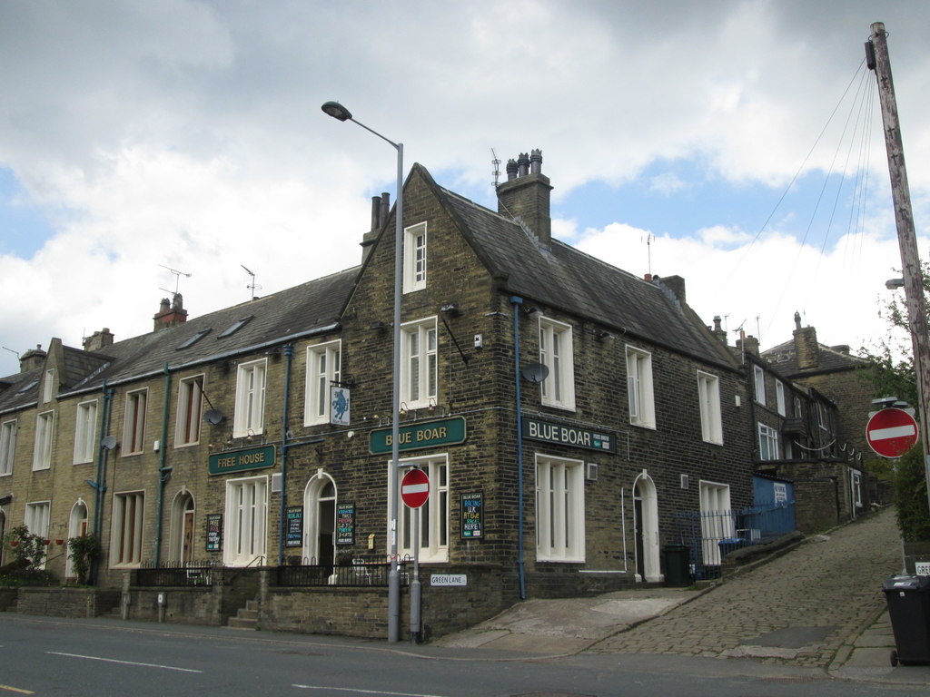
© Copyright John Slater and licensed for reuse under this Creative Commons Licence.
Boggart House, shown in the 1851 and 1861 censuses as Bogerd House, and the 1852 map as Boggart House. A farm of 21 acres. South of Lower Sandal, on Black Carr, off the Brighouse and Denholme Road in that part of Thornton transferred to Queensbury civil parish in the year 2004. Boggart House is not shown on the 1893 map.(updated 17 August 2023).
Bottom of the Row On the 1852 map: Dwellings between Thornton Road and Hill Top Road, what is now called Close Head.
Bottomley Holes On the 1852 and 1893 maps, and since. Some dwellings at the Brighouse and Denholme Road end of Cragg Lane, and to the south-east of Cragg Lane. Note: Cragg Lane is still called Bottomley Holes by many residents and Bottomley Holes now has a postcode which is different from Cragg Lane, with neighbouring houses either on Cragg Lane or Bottomley Holes, with different postcodes. (Updated 25 June 2023)
Boundary stone On the 1893 map, where Thornton Road crossed Pitty Beck
Boundary Stone On the 1933 map, at the south west side of Keelham crosroads, the start of the south side of Brighouse and Denholme Gate Road.
Bowling Green (Bradford Council’s) On the 1921 map, where it is now, via a path from Wensley Bank West. Photographs of its opening n 3rd May 1915 by Alderman Sam Horsfall, are in the Bradford Weekly Telegraph of 7 May 1915. (updated 2 April 2025)
Bowling Greens There were 3 bowling greens in Thornton, one in the grounds of Brooklands, one behind the New Inn, and the only remaining one, off Wensley Bank West. (updated 2 April 2025)
Bradford and Thornton Railway Shown on the 1893 map, but opened in 1878.
(The) Bradford and Thornton Turnpike Trust Shown on the 1852 map. The Turnpike Trust built and maintained Thornton Road from Bradford city centre to Halifax Road, from 1826 to 1861. The section from Leaventhorpe Hall to the Keighley and Halifax Road was not built until 1829. At this time and well into the 20th Century it was called New Road. Two other Turnpike Trusts served part of Thornton, the Brighouse and Denholme Gate, and the Keighley and Halifax. It’s difficult to imagine what Thornton looked like before building of the Turnpike Road in 1829. The main road followed the Thornton Old Road from Fairweather Green, then to what is now called Leaventhorpe Lane, on to what is now called Old Road, and then onto Market Street. The disappearance of part of Old Road came with the building of the Council estate from the 1920s. The western section was renamed Brontë Old Road.
Branwell Brontë Close, see Gleeson development. (updated 12 July 2023)
Brewery Lane, West Scholes, runs from Carter Lane to West Scholes hamlet. In that part of Thornton which was transferred to Queensbury civil parish in the year 2004. (updated 17 August 2023)
Bricks Shown on the 1852 map. A terrace of houses at the junction of Old Road and Thornton Road where the New Tyke’s carpark is. Bricks, including the Leventhorpe Inn were demolished in about 1972.
Bridge Street On the 1893 map, from Thornton Road to Market Street. Pedestrian entrance only from and to Market Street. Housing on west side only. Numbers 1 to 17 are Grade II Listed Buildings dating from about 1800. In the 1851 Census Bridge Street was called Rag Row. In the Bradford Observer of 27 October 1867, there was a report of the recent Thornton Local Board meeting where a complaint had been received that the pig-styes in Rag Row , owned by Mr. James Pearson, were a nuisance and injurious to health. The complaint was referred to the Sanitary Committee for action. In the Bradford Daily Telegraph of 25 April 1890 there was a court report, of a case of “trying to commit suicide.” The charge was against Elizabeth Feather, aged 13 a mill-hand, who lived with her parents in Bridge Street. It was stated that the girl went out on Monday night to pay some pew-rents for her father, and as she did not return until late, he was angry with her. The next morning she was seen to go to a mill dam in the neighbourhood, and deliberately throw herself in. A man named Sutcliffe was there at the time, and he rescued her. The parents of the girl said that they could not assign any reason why she acted in such a foolish manner. Upon promising not to repeat the attempt, she was discharged. (Updated 26 June 2023)
Brighouse and Denholme Road, now the A644, runs from Keelham towards Queensbury and on to Brighouse. It has different names in different localities. Number 40 at Mountain, previously the Mountain Eagle Inn, is a Grade 2 Listed building. Its Listing states: “The former public house is a circa 1850-60 building of two-storeys sandstone “brick” with rusticated ashlar quoins. Moulded stone eaves cornice, coped gable ends and flanking chimneys. Two windows, tall two-light square mullion casements on first floor, modern bows inserted to ground floor. Doorway with cornice on console brackets. Rear wing with two-light square mullion window links No 44. This is a partial rebuild of an C18 house, two-storeys, sandstone. Original gable end to north with saddlestone and kneelers. Five light mullioned first floor window, three lights blind. Former first floor doorway now adapted to window.” (Updated 14 September 2023)
Brighouse and Denholme Gate Turnpike Trust Grade II Listing buildings are: Numbers 1 and 3, dating from about 1800 to 1820; 7 and 8, dating from around 1820; and Shay Farmhouse and Integral Barn dating from the late 18th Century, or around 1800;
Brockton Top off Cocking Lane in that part of Thornton which was transferred to Queensbury civil parish in the year 2004. It appears in the 1861 and 1871 censuses. (updated 18 August 2023)
The Brontë Birthplace, Market Street. The Brontë birthplace now has a blue plaque. 72 and 74 Market Street, with front garden wall and railings to 74 are all Listed, grade II*. Built in 1802. Former butcher’s shop built in mid 19th century. Historic England’s Listing states, (in addition to the entry under Market Street) :
House, 1802, home to the Bronte family 1815-20 and birth place of Charlotte, Emily and Anne. Projecting shop (no.72) added mid C19.
MATERIALS: thin coursed sandstone used similar to brick, sandstone dressings and stone slate roof.
PLAN: central entrance plan with a single storey shop projecting forwards from the right, (east) bay.
EXTERIOR: this is a small, two storey, three bay house that is attached to the flanking properties to the sides. The symmetrical frontage has large square windows divided into paired lights with central stone mullions, the window above the central door being a single light. All of these windows have plain stone surrounds and 2-over-2 sashes. The central door has a similar plain surround, but also has a moulded cornice supported by simple console brackets. The eves is corniced, this being supported by small, paired modillion brackets. The mid-C19 projecting bay is canted to the west with a doorway set in the corner. Facing the street to the south is a large shop window with a 3-over-3 sash and a folding awning, all protected by a moulded stone cornice supported by moulded consoles.
INTERIOR: not inspected.
SUBSIDARIES: extending to the left (west) of the front door, enclosing a small front garden, is a wall topped by short, wrought iron railings with fleur de lis and honeysuckle heads. (Updated 24 October 2022)
© Copyright David Spencer and licensed for reuse under this Creative Commons Licence.
Brontë Birthplace Blue Plaque

At the time of the Brontës, Thornton Road was fields. It was not built from Bradford to Leaventhorpe Hall until 1826, and from there to the Keighley-Halifax road, now the A629, until 1829.
Currently the Brontë Birthplace is closed. A campaign group to buy it as a community asset has bought the Brontë birthplace (updated January 2024)
Brontë Court Built in 2020 A new cul-de-sac to the north of Sapgate Lane, the entrance being opposite 50 and 52 Sapgate Lane.
Brontë Old Road Shown on the 1933 map. The new name for the western part of Old Road from Springhead Road to Market Street. The even numbers run from 188 to 204, being a continuation of the numbering on Old Road. The odd numbering is from 1 to the 90s.
Brontë Place Shown on the 1933 map. Between Thornton Road and Brontë Old Road.
Brontë Royal Mail Post Box: This is no longer a place, because it was in place for only a fortnight before Royal Mail replaced it with a normal mailbox, but as this website doesn’t have a separate History section, the box is in Places. Photographs of the box can be seen here. (Updated 7 January, 2021)
Brontë Way, 1 is a long distance footpath between Birstall and Padiham in Lancashire, which passes through Thornton. See details in the Walks section of this website. (updated 12 July 2023)
Brontë Way, 2 is the name of a new road in the Gleeson development on the west end of Thornton – see the illustration under Gleeson development. (updated 12 July 2023)
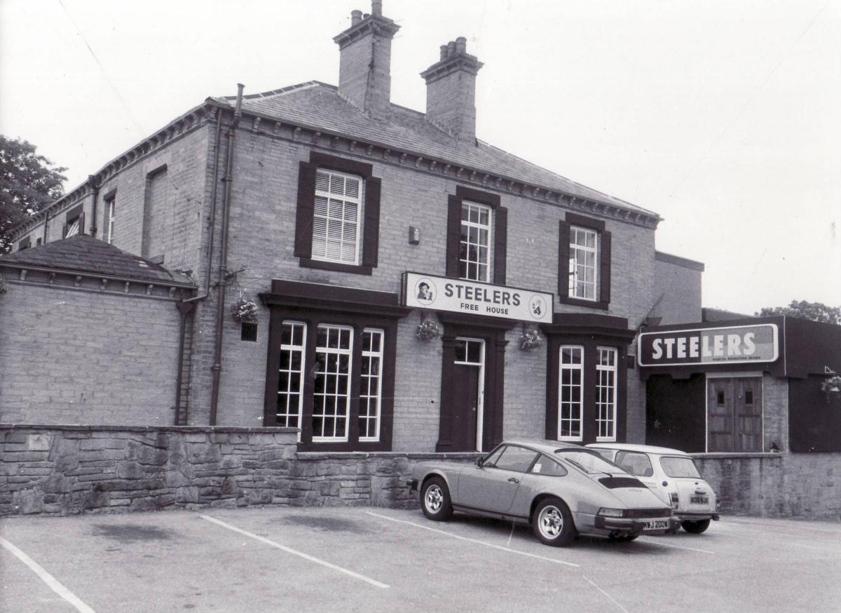
Brooklands Shown on the 1893 map. A house and grounds where Currer Bell Mews is now, on Brooklands Avenue. It is thought that there was a bowling green here. In the early 1900s a Mrs Rawson with her three daughters, all described as Gentlewomen on the 1911 census, lived at this house. One, Alice, married Geoffrey William Northrop, the elder son of Mr. Alfred Northrop owner of Albion Mills. Geoffrey died of sickness as a result of war service and is remembered on Thornton War Memorial. In the 1940s John Lee lived there, at which time it was the Brooklands Club. John was killed by the Japanese in 1941 while he was serving in the Royal Scots Guards in Hong Kong. He is also remembered on Thornton War memorial. The Brooklands Club became the Thornton Working Men’s Club, then Nosy Parkers, owned by a Mr. and Mrs Steve Parker in the 1950s, and around 1978 it was owned by David Parker. Later it became Steelers, and after that it became Mr. Ts, and then The Northcliffe, before demolition and the building of Currer Bell Mews. (Updated 6 November 2024)
Brooklands Avenue Shown on the 1933 map, built and named after Brooklands House
Brow Bottom On the 1852 map: An area south of Aldershcoles Lane opposite Throstle Nest.
Brown Cow Inn On the 1852 map: at the Keelom crossroads. Converted back to 3 dwellings in the 2010s, now 1366, 1368 and 1370, Thornton Road, dating from around 1820, grade II listed buildings.
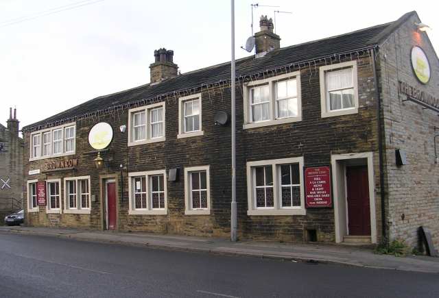
The Brown Cow – Thornton Road, Keelham
© Copyright Betty Longbottom and licensed for reuse under this Creative Commons Licence.
Buffham Pastures a residential cul-de-sac built eastwards from Allerton View. Named after John Buffham, who was born and lived in Thornton. He was a Thornton councillor on both the Corporation of Bradford and the later Metropolitan District of Bradford, deacon at the then Sacred Heart Church, active in the Royal British Legion, etc.
Bull’s Head public house shown on the 1852 map. At the junction of Kipping Lane with Market Street (and West Lane) as shown on the extract of the 1893 map. The copyright owner of the photograph is unknown. It was demolished around the 1920s. The Bull’s Head in the news:
- 18 June 1897, in the Bingley Chronicle. A report into the Inquest of Mrs. Pickles, who, it was alleged had been murdered by her cousin, Walter Robinson of Thornton. It was stated by a witness that Walter Robinson had been to the Bull’s Head but did not appear to be inebriated.
- 24 September 1897 (in the Bingley Chronicle), Thornton CC, winners of the League trophy for 1897, played a match against The Rest, that is the Rest of the First Team division of West Bradford League. It was a 12 a side match which resulted in a tie. The League Committee held an evening meal for both teams at the Bulls Head. Over 100 people were catered for.
- 17 June 1898, in the Bingley Chronicle, The West Bradford Cricket League committee met at the pub. At that time Thornton had played 9 games and had 12 points, They were 3rd, below Cullingworth with 15pts and Allerton with 13 points.
- 16 June 1899, in the Bingley Chronicle, The West Bradford Cricket League Committee met at the pub. at that stage Thornton headed the table with 14 points from 9 games, Allerton were 2nd with 13 points and Great Horton rd with 12 points.
The earliest newspaper reference found is in the Leeds Mercury of 3 January 1807 in which there is an advertisement for the sale of a farmhouse, barns and other buildings and land in Thornton. It stated tht the land contains valuable beds of coals and stone. (Updated 8 June 2023)


Extract from the 1893 25″ to the mile map. Reproduced with the permission of the National Library of Scotland for non-commercial use.
Bunkers Hill Farm Shown on the 1921 map, off Tewitt Lane near Thorn Gate.
Camomile Court a newish cul-de-sac off Thornton Road, nearly opposite the entrance to Thornton Cemetery.
Carr House First shown on the 1852 map. A farm to the northwest of Cocking Lane.
Cassina Court Between 5 and 11 Back Lane, towards the Sapgate Lane end of Back Lane.
Cavalry Inn, was at 418 Thornton Road, that is in the vicinity of the bottom of Ball Street, on the opposite side to 420, (Harrop House), which still exists. Old number 28 New Road. Existed at least between 1868 and 1916. In October 1868 the Thornton Board of Health received a complaint of a nuisance in Ball Street, caused by a privy, ashpit and horse manure near to the Cavalry Inn. It was agreed that the Sanitation Committee visit the site. The Bradford Observer of January 15, 1875 stating “Beerhouse to let with immediate possession: the Cavalry Inn, Tornton. For particulars apply to the tenant, or to Messrs J. and H. S. Hirst, Low House Brewery, near Bradford.

Cavalry Inn. Copyright owner not known (Updated 29 July 2023)
Chapel Shown on the 1893 map, and became Thornton United Methodist Chapel by the 1921 map. Built in 1857 by “Free” Methodists who broke away from the Wesleyan Bethesda Chapel at the junction of West Lane and James Street in about 1852. Before their Chapel was built they worshipped at the Athenæum at the bottom of Commercial Street. South of Thornton Road opposite Firth Street, with a Sunday School to the south of it, abutting John Street.
Chapel Street Shown on the 1893 map. From Thornton Road to John Street alongside the Chapel and Sunday School and housing.
Chapel Terrace Shown on the 1893 map. Back to backs shared with the east side of Henry Street. There are only houses on the west side of Chapel Terrace. The Chapel was Thornton Congregational Chapel formerly on the higher land in what is now Kipping Gardens. It was demolished in 1982.
Charlotte Brontë Way see Gleeson Development (updated 12 July 2023)
Chat Hill On the 1852 map, the hill between Pinch Beck and Westfield House.
Chat Hill Road On the 1908 map, now named, from Thornton Road to Cockin Lane. The building we now know as an Italian restaurant was built in 1938-9 as the new School Green Co-op. Oxheys Farmhouse is Grade II listed, dating from the latter part of the 17th century.
Chat Hill / Chat Hill Road in the News. While some details given might seem a bit mundane, two are major news items.
- 1867 September 19. A report in the Bradford Observer of a duck, of the common breed, which began to lay in February of that year, and has from then until the report’s date deposited in the nest nine eggs of regular size every week, and last week it laid 3 useful eggs in one day. The duck was bred by Mr. James Pickles of Chat Hill.
- 1874, February 26. A report in the Bradford Observer of a new proposed Huddersfield, Halifax and Bradford railway, which beyond the Midland Railway station in Bradford would have a line to Manningham, and then via a cutting, almost parallel to Thornton Road at the rear of Illingworth’s Mill, go to a station near to the junction of Whetley Lane and Thornton Road, called Girlington Station, when the line would then continue to behind the cottages at 4 Lane Ends and then the line would turn in the direction of Bullroyd Lane and Allerton, with a new station for Allerton between Thornton Road and the “Oaks” (Somewhere around the current junction of Oaks Lane and Rhodesway). The line would then continue in cuttings and moderate embankments in “an easy curve under Thornton Road 150 yards beyond Leventhorp Hall” (i.e. on the Thornton village side). It then would have continued southwards of Westfield House “to Chat Hill where it passes under the road opposite to Thornton Hall, and about a quarter of a mile from Chat Hill it is proposed to make a new station for Thornton.” After that the line went via embankments and cuttings via Dye Royd and Lower Headley to a tunnel, 2,508 yards long through Summit or Mountain, towards Holdsworth and on to Halifax. At the time of the report a Bill for Parliament to approve was being worked on.
- 1893, March 3. A headline in the Bradford Daily Telegraph: “A singular affair at Thornton”…A destitute labourer’s end”… “Poor Law officials at variance.” The destitute farm worker was Samuel Ambler, latterly of no fixed abode, but both the landlady of the School Green Inn, and his brother who worked at Clayton Gas Works on Low Lane, would feed him from time to time. The Inquest by the Bradford Coroner at the School Green Hotel heard that the poor Samuel was unwell and suffering heavy coughing. He was seen by one witness leaning against a wall on Chat Hill Road, coughing. He then fell in the road, and when the witness went to him, he was dead. The inquest heard that he had been seen by the Poor Law medical officer and the “relieving officer” who suggested he go voluntarily to Clayton Workhouse, but he refused and said he’d visit his brother. The two poor law officers who considered he had bronchitis as well as being mentally ill, eventually persuaded him to go to the workhouse, and gave him a certificate on plain paper, as they had no proper forms, to take to the Master of the workhouse. It appears that the Master asked the destitute Samuel if he wished to enter the workhouse, to which Samuel replied that he didn’t and he went away. The two Poor Law officers said that the Certificate contained the words “mental condition”, while the Workhouse Master, who appeared to have disposed of the Certificate said it didn’t. The Coroner’s jury returned a verdict of natural causes.
- 1894, January 11. A report that an application was made to the Thornton Board of Health, for a water supply to three cottages at Chat Hill, owned by Messrs. Metcalf and Pearson. It was agreed.
- 1936 June 8. A report that a bus travelling down Chat Hill Road ran into a gas lamp, knocking it down, demolished part of a wall, and stopped with one wheel in a field. One of the 5 passengers had a bruised knee. The other passengers and the driver were not injured.
- 1937, January 9. There was a report in the Bradford Observer that a safe, which had been stolen in a robbery at the Yorkshire Rubber Company at 257 Manchester Road between 12 midnight and 1am, had been found five hours later, with its back ripped off, in the middle of Chat Hill Road. The money was no longer in it, but the books and documents were, It is thought to have been thrown off a moving vehicle, and that there were at least 3 men involved it the robbery.
- 1939, August 23. An article in the Bradford Observer read: “Progress with Bradford’s Pipe-Line” The articles reads: “Good progress is being made in the laying of Bradford’s biggest concrete pipe-line. This new tunnel will carry the waters of the Bradford Beck under the £105,000 western by-pass road at Chat Hill, Thornton. Each section of the tunnel is 6ft. 6in. in diameter, is 4ft. wide apart from the lip, and weighs 2 tons 2cwt. Only four sections can be delivered at a time, and when all the sections have been cemented together, the tunnel will be 196ft. long. It will rest on a concrete foundation 14in. thick on the old bed of the Beck, which has temporarily been diverted, and it will be strengthened by a 9in. layer of concrete all round.” 10 days later Britain declared war against Germany, meaning the scheme never went ahead. By Bradford Beck it means Pinch Beck and Clayton Beck.
- 1947, January 23. New Council houses had been built on Chat Hill Road, with the Lord Mayor officially opening them for inspection. One of one pair had been furnished by the Bradford Co-op.
- 1953, October 19. The Yorkshire Post and Leeds Intelligencer reported that a bus with 30 passengers ran backwards for 50 yards down Chat Hill, Thornton. The bus collided with a wall, but none of the passengers were injured. It stopped when it crashed into a garden wall, missing a boy pushing two babies in a pram. (Updated 25 August 2023)
Churches and Chapels to date. Up to the early 20th century Thornton was a centre of non-conformity in religion. Kipping Chapel was built in 1769 in Market Street, but the current building dates from 1843, though worship took place in Thornton long before that, probably as far back as the 17th century at Kipping House and Kipping Barn. Kipping Chapel had both a Sunday School, and a Day School. Chapels connected to Kipping Chapel were at Yews Green and on Hill Top Road.
The Old Bell Chapel, St. James Church, 1598 or 1612. Parish Church records in West Yorkshire Archives go back to 1620. The current St. James Church was opened in 1870. There was a Mission Hut built on Hill Top Road, where Abe Shaw’s now is on the 1891 map connected with St James Church. (to be continued)
Churchill Road Shown on the 1933 map. Runs south eastwards from Thornton Road to join Heys Avenue.
Clews Moor Shown on the 1852 map. The land to the northwest adjoining the Brighouse and Denholme Road, south of Higher Sandal.
Cliffe Lane Named on the 1893 map, running north-westwards from the junction with Sapgate Lane and North Cliffe Lane. At its north-western end it linked up with Small Lane, shown on the 1849 Tithe Award map, which led to a road between Pikeley and Yew Tree, west of Allerton Upper Green. (Updated 12 April 2024)
Cliffe Street Shown on the 1893 map. From Reservoir View, northwards to open ground. Shares back to backs with both Moss Street and South Street. (Updated 5 December 2023)
Cliveden Avenue a cul-de-sac from Oakhall Park, built 1999/2004. (Updated 26 April 2023)
Clog Raw, in the 1851 census, thought to be in Mountain, in that part of Thornton which was transferred to Queensbury civil parish in the year 2004. As mentioned elsewhere the person who wrote up the census return from housholders’ surveys was not very good at spelling. He gives 2 peoples’ place of birth as “Linkinshire”, (Lincolnshire). (updated 17 August 2023)
Clog Street, Black Carr Terrace in the 1861 census, in that part of Thornton civil parish which in the year 2004, was transferred to Queensbury civil parish. 3 dwellings. (updated 18 August 2023)
Cloggers Row, (8 – 30 Market Street) Most of the cottages in Market Street and adjacent areas were built in the late 18th and early 19th centuries. The first in Cloggers Row has a date-stone of 1806. Number 20 is very narrow and known as the Doll’s House. Grade II listed buildings: dating from about 1806.
Close Head a lane which adjoins the east end of the Thornton bus turning circle and goes northwards to a group of dwellings which are now called Close Head but were previously called Bottom of the Row.
Close Head House On the 1921 map named, with a footpath from Pearson Place. With the adjoining barn is a Grade II listed building dating from 1857.
Close Head Drive From Thornton Road to Ash Tree Avenue, built.
Close Head Lane On the 1852 map The road that is now Well Heads. On the 1894 map a Congregational Sunday School built on the edge of the second field from Half Acre road junction, to the south of the lane. It continues to be called Close Head Lane on the 1933 and 1947 ordnance survey maps, although at it western end was called Well Heads. (Updated 27 April 2023)
Close Head Row On the 1891 map. Intermittent dwellings from Bottom of the Row in the east to Top of the Row in the west, south of the then called Close Head Lane (Well Heads).
Clough in the 1841 census. Situated off a lane, opposite Law Hill, which runs to a dwelling between the site of former coal pits or mines. It is shown on the 1852 Ordnance Survey map. Now demolished. Clough was in Thornton civil parish until the year 2004, when it was transferred to Queensbury civil parish. (Updated 15 August 2023)
Clough House in the 1861 census, still thought to be a group of houses at Clough. Clough House later moved to Low Lane.
Coach and Horses Inn, located at 859 Thornton Road (83 New Road), in existence between at least 1893 and 1916. (updated 5 May 2023)
Coach Lane is an old lane which runs from what was the main route to Bradford (now Brontë Old Road to Thornton Hall, the Hall Farm and the Parish Church, (now known as the Bell Chapel.) Try to imagine Thornton without Thornton Road, when the main access to Thornton Hall, Thornton Hall Farm, and the then Thornton Chapel of St. James was Coach Lane from what is now called Old Road and Brontë Old Road which were joined until the Council estate was built in the 1920s. This part of Thornton Road didn’t exist before 1829. Thornton Hall is a Grade II* listed building dating from the late 17th century. Other listed “buildings off Coach Lane, all Grade II are Stocks in the garden of, and to the east of, Thornton Hall. The stocks date from the 17th or 18th century; Garden wall with 4 bee boles inset, to the north-west of Thornton Hall, said to be 17th century, and the ruins of the Chapel of St. James, the old Bell Chapel, originally built around 1612.
Coal Mining and coal pits. There were numerous areas of coal extraction in the 20th, 19th and earlier centuries. The Northern Mines Research Society have identified the following coal mines in Thornton: )
- Alderscholes Pit, of which the engine shed still exists.
- New Road (c) in the vicinity of Camomile Close
- One close to Tesla Security, Thornton Road
- New Pit, near to Myers Building supplies, Thornton Road
- Roadside numbers 1&2 in the field west of 1164 Thornton Road, Thornton.
- Keelam Pit in the field on the opposite side of the road to Robertshaw’s Farm Shop
- Near to Upper Shay Farm
- Clews Pit on Brighouse and Denholme Road
- Mountain End Pit, off Pit Lane, east of Law Hill
- West Scholes Colliery
- Clayton Fireclay
- Birks Fireclay
- Stream Head and
- Hazel Crook.
The 1849 Thornton Tithe Award, which includes Denholme, has 40 occurrences of field names which include the the words “coal” or pit”. (Updated 10 August 2023)
Cocking Lane In the 1841 Census and named on the 1852 map. (Updated 10 August 2023)
Coffin End 1 Havelock Square, locally known as the Coffin End building, is an unusual three storey terminal feature to the row of simple cottages climbing the hillside; includes a basement. Formerly the Star Inn, it was one of three alehouses existing in the village in the 1800’s. The cottage, built circa 1820. The photograph was taken in 2005 before an historical renovation of the building, and renewal of the sett paved road, by a local resident, not by Bradford Council. It is a Grade II Listed Building
Coffin End
© Copyright David Spencer and licensed for reuse under this Creative Commons Licence.
Commercial Street was not built on the 1849 Tithe Award map, but the Athenæum was in use in 1852. The Athenaeum was built on the east side of Commercial Street at the junction with Thornton Road and was a centre of literature and the arts, a place with periodicals and newspapers. During its lifetime the “Free” Methodists who broke away from the Bethesda Wesleyan Methodists, worshipped at the Athenæum from 1852 to 1857 until their new Chapel had been built on the site where the current Methodist Church is on Thornton Road. Debates were held at the Athenæum, and for part of its life it acted as a Mechanics Institute. Following the Liquidation of Francis Craven and Co in 1874, an extensive sale took place in January 1875; included in this sale was the Athenæum. (I am currently researching Francis Craven, and in due course more details will be given). (last updated 12 April 2024)
It appears that all of Commercial Street was built in 1851 or 1852. It had a mix of housing on the west side including some courts accessible through similar passages as the Ball Street passage, with back to backs shared with Industry Street on the east side. From Market Street to Thornton Road. See the map under the heading of Industry Street. The top half of Commercial Street remains today, between Market Street and the Thornfield Hall boundary. (last updated 22 February 2023).
Congregational Chapel see New Road Congregational Chapel.
Congregational Sunday School, established in 1859, originally on the road called Close Head Lane, (now known as Well Heads). Foundation stone laid by Mr. Wilson, perambulator manufacturer, likely to have been William Wilson of Hunslet whose company became, after his death, Silver Cross Prams. An article in the Bradford Observer of 25 May 1865 states that Mr. John Hill preached in aid of Sunday schools at the Well Heads Sunday School, the collection being £10 10 shillings and 11½ pence. The Bradford Observer of the 13 July 1869 refers to services in aid of Sunday schools, and refers to two branches of Kipping Sunday School, at Yews Green and at Well Heads. The Bradford Daily Telegraph of 3 November 1914 reported that the Ladies Class at the Sunday School had donated five shillings to the Belgian Refugees Fund. The Sunday school, no longer used, was sold and a house built on its site from the mid 1970s, being the first house on the left going from the junction of Well Heads from Half Acre Road and Hill Top Road. The film about the Formation of the Thornton Home Guard, shows the Well Heads Congregational school as a base. The photograph is a screen shot of the School, at 19 minutes and 20 seconds of the film. It’s worth watching the film around that point for views of the school. (updated 5 November 2023)

Conservative Club On the 1921 map, on the south side of Thornton Road near the top of Lower Kipping. The Conservative Club occupied 10 Kipping Lane, (formerly a warehouse built in the 1820s for Jonas Craven, Worsted manufacturer), from 1879 to 1912 when the Friendly Inn was purchased, reconstructed, renovated and refurnished. It opened in 1913. Up to 1945 one third of the building was the Club, one third occupied by a solicitor, ad one third a shop. From 1945 two thirds were the club and the other part was a shop, occupied by Calvin Pickles, Greengrocer. ( Updated 2 March 2024)
Copper Kettle Inn. A modern name for the former Victoria Inn at Keelham crossroads, now closed and a private house. In Denholme civil parish. (Updated 20 February 2023)
Corn Mill Lane an access road to stabling and buildings on the site of the former Thornton Corn Mill, off Cockin Lane.
Corrie Fold is effectively made up of houses on Corrie Street which are easier to access from Corrie Fold on Sapgate Lane. (Updated 12 April 2024)
Corrie Street On the 1908 map, thought to be named after Dr. Joseph Corrie, a surgeon and member of the Thornton Local Board of Health. Dr. Corrie, lived at Corrie House from 1837 to at least 1872. Corrie Street leads from Market Street to Sandmoor Close. 1 Corrie Street and 18 Sapgate Lane date from the early 19th Century and are grade II listed buildings.
Cote Gap On the 1852 map, and on the 1770 enclosure Award map. Dwelling where Cote Gap is now.
Cowburn Farm, 19 + 21 Market Street with barn. Since it ceased to be a farm it has more recently been the offices for GSB Prospection, the company known for its geophysics in Channel 4’s archaeology programmes called Time Team. The farm has since been sold. The rear of the farm buildings face Market Street. The low height of the doorways show that the road surface was previously lower than it is now. Built as three dwellings, dated about 1800 to 1830. Grade II listed building.
Crag On the 1852 map. A building on the south side of Cragg Lane.
Cragg Lane On the 1891 map. Named, with some dwellings shown. The only Listed Building on Cragg Lane is now known as Intake Farm and Barn, Grade II.
Craven Avenue named after Joseph Craven, mill owner and later the MP for Shipley, when Thornton was in Shipley constituency. He owned land at the Market Street end which he gave to the Mechanics’ Institute for a purpose-made home for the Institute. Craven Avenue is shown on the 1893 map, a narrow street linking Market Street with Thornton Road, to the west side is a Chapel (Kipping), and an unnamed building (Kipping Manse). To the east of Craven Avenue, facing Market Street is an un-named building , (Thornton Mechanics’ Institute). South of the Mechanics’ Institute is Thornton Grammar School. (where the Medical Centre now is). It is no longer a through road for vehicles. (Updated 1 July 2023)
Cricket Ground On the 1891 map, with pavilion, north of Hill Top Road, and west of Long Row, as now. Thornton Cricket Club was founded about 1853, though there were cricket matches played in Thornton before then.
Croft Head Works (Shuttle) On the 1921 map, approximately where Market Court is now. See Ingham’s Shuttle Works
Crown Inn In the 1871 shown as at 11 New Road, (Thornton Road), on the eastern junction of Dole Street and Thornton Road. The building now has a porch. In 1871 the Inn keeper was Francis Fielding.

The Crown Inn. Copyright holder not known. (Updated 29 July 2023)
Dean Lane On the 1852 map. A lane leading up hill from Egypt to Dean Lane Head. (Now in Allerton civil parish)
Dean Lane Bottom On the 1933 map. A farm on the left side of Dean Lane, just after Egypt. (Now in Allerton civil parish)
Dean Lane Head On the 1852 map. A cluster of dwellings at the junction of Dean Lane with Back Lane and Old Allen Road. (Now in Allerton civil parish)
Deep Lane On the 1852 map. A road, as now, linking Malt Kiln Lane with Brighouse and Denholme Road. Squirrell Hill Farmhouse dates from 1687 but was largely rebuilt in 1800. It is a Grade 2 Listed Building.
Delf / delph – definition: A quarry or mine; especially (in later use) a small quarry
Denholme Clough On the 1892 map. At this time shrunk northwards, previously in 1852 an area / the name of the road, including most of Keelham crossroads.
Dole – definition A meadow in which several people have shares, for example within a common field. (From the Middle English “dole” meaning “a portion of land”). (Updated 1 July 2023)
Dole Mill (Worsted) An article in the Bradford Observer of 7 September 1877, says it was built in 1844. The Tithe Award Map of 1849 shows a building in the correct place which is owned and occupied by Jonas Craven and it is described as a “Mill, Reservoir, Yard, and Gardens”. The history of it is, largely, the history of its owners. (Jonas) Craven and Harrop were textile entrepreneurs long before the mill was built. After them, Jonas Craven’s son, Francis took over the running of the mill, until his downfall from 1874. Then Mr. Briggs Priestley took over, followed by his son, William Edwin Briggs Priestley, followed by a take-over by the Yorkshire Woollens and Worsted Group. In the biography of Jonas Craven on this website there is detail about the formation, operation, and after 30+ years the dissolution, of Craven and Harrop, (Updated 10 July, 2024).
Dole Street Shown on the 1849 Tithe Award map. A short street leading southwards from Thornton Road, as now, but originally to Dole Mill. Located in the Thornton Conservation Area. 2-6 Dole Street are Listed buildings dating from about 1830. They are back-to-back dwellings with 323-327 Thornton Road which are also Listed Buildings.
Dolls House see Cloggers Row.
Dolroyd see Dye Royd
Driver Square in the 1841 Census. Thought possibly a former name of Havelock Square. (Updated 20 February 2023)
Driver’s Field in the 1841 and 1861 censuses. Thought possibly to be a former name of Havelock Street. (Updated 20 February 2023)
Duke of York Hotel Named on the 1921 map. Now in Allerton Civil parish. A Listed building, originally a 17th Century farmhouse, enlarged in 1800-1810.
Dye Royd Shown on the 1852 map, called Dolroyd in the 1841 census. Farmhouse and barn are Grade 2 Listed buildings dating from the 17th and 18th centuries on a longhouse plan with adjoining barn. Dwellings half way up Headley Lane to the south east. (updated 16 August 2023)
