Bradford Council has published, for consultation, the Draft Bradford District Local Plan – Preferred Options (Regulation 18) and Call for Sites.
That download gives all the new proposed housing sites in Thornton, plus related information. Bradford Council consulted the public on their Draft, see here for further details. The final date for comments was 23:59hrs on Wednesday 24 March 2021.
Local Plan Period and total number of new dwellings proposed
The plan period is from 2020-2038 and 575 new dwellings are proposed. The previous plan period was 2013-2030 when 700 new dwellings were proposed. Since 2013 new dwellings have been built opposite the Cemetery (Kellet Drive, Woodsley Fold, and Rowlands Close), on Old Road, Allerton View and Buffham Pastures, on the north part of the Downs Coulter site between James Street and West Lane, behind 79-111 Sapgate Lane, and at Valentine Court, and 160 dwellings are being built to the south and west of Myers building supplies on Thornton Road. (this latter site is a Preferred building site in the proposed local plan as at 2021, site TH/027 – see details below.
Since 1947 it has been the duty of Councils to identify land for housing, employment, recreation and other uses. Statisticians work out how many new dwellings are needed in each Council area, and the Council decides where those extra dwellings should be. In 2013 the Council produced a document suggesting many areas around Thornton where new dwellings could be built and sought the views of all who wanted to give their views. As a result of that consultation, a reduced requirement for dwellings at Thornton, and a new period (2020-2038 instead of 2013-2030).
Dwellings include flats or apartments as well as houses.
The proposed areas for dwellings during 2020-2038
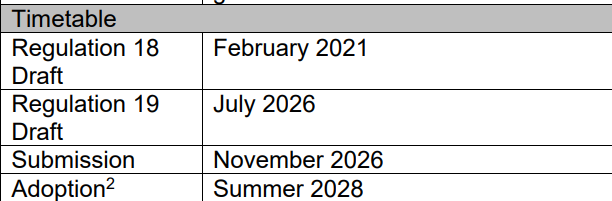
The Thornton Area Plan, see below, shows where each area for new housing is. Each area will be shown in greater detail below it. NOTE: These are still proposals, at what is called Regulation 18, Preferred Options, of the Draft Local Plan. A draft plan will be published, which will be examined by a Planning Inspector from the national Planning Inspectorate. She or he may make recommendations to the Council regarding the Plan. The stages which must be gone through before the Local Plan is adopted. are shown in the illustration. Regulation 19 is due for publication in July 2026.
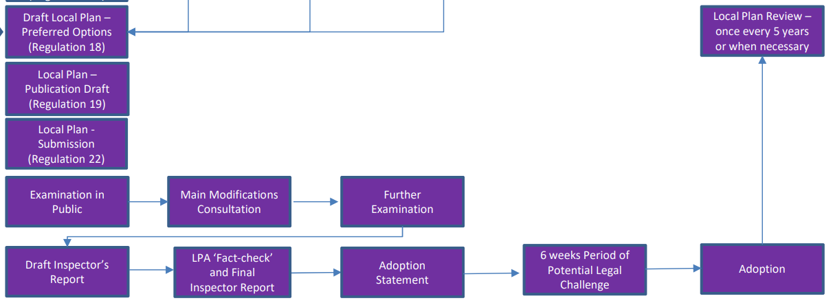
The timetable up to adoption is shown below.
The preferred sites shown as at February 2021

The Council has re-numbered some of the sites, so the new site numbers are shown. Below is a plan of proposed housing sites between between Thornton Road and Hill Top Road, with new numbers.

Proposed site TH/002A (formerly TH1/HC)

This area received planning permission for 11 dwellings, dated 13/7/17. The area originally formed the most northern part of a larger housing area, reference TH/002 Close Head. Land to the west of Thornton Cemetery in the former proposed Bradford Development Plan. The larger area, from Thornton Road near the bus turning circle to the dwellings at Close Head Lane, plus the TH1/HC site received planning permission in 2008, but hasn’t proceeded because of access issues at the Thornton Road end. The land, TH/002A is owned by Bradford Council. The estimated number of dwellings for this site is 11. The site could be incorporated into wider development with sites TH/033A and TH/033B, see Western Masterplan Area (Updated 28 May 2026)
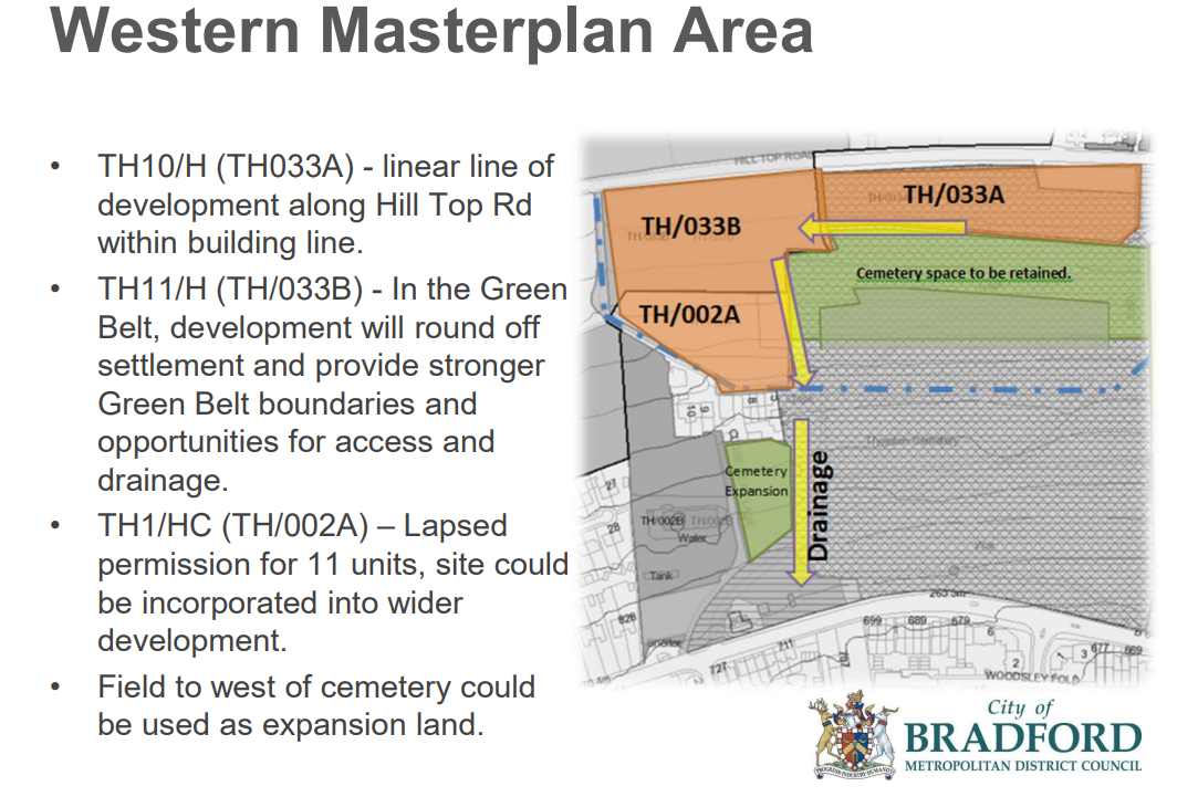
Proposed site TH/033A (previously TH10/H)
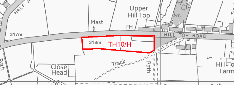
Land at the top of the cemetery opposite the Ring o’ Bells, some of it used as a car park for that pub. See Western Masterplan Area. The estimated number of dwellings for this site is 27. (updated 28 May 2026)
Proposed site TH/033B (Formerly TH11/H) see Western Masterplan Area, above
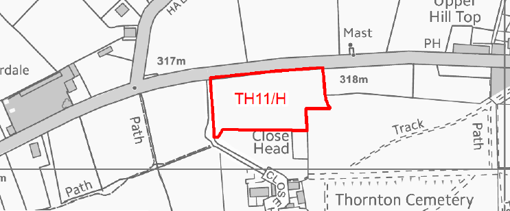
The estimated number of dwellings for this site is 27. (updated 29 May 2026)
Proposed site TH/003, (formerly part of TH2/H)
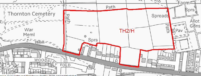
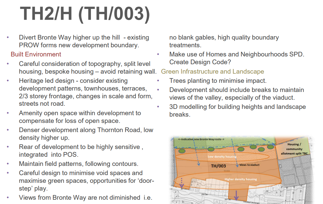
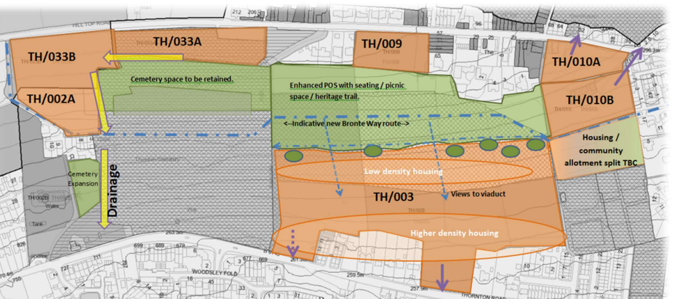
TH/OO3 no longer extends northward on the Cemetery side to meet a site off Hill Top Road. The site, TH/003, most of the land is owned by Bradford Council, though some is owned privately. The estimated number of dwellings for this site is 150. See also TH/010B (Updated 29 May 2026)
Proposed site TH/006 (previously TH3/H)

The unkempt land between Foster Avenue and lower Coach Lane. Privately owned site. The estimated number of dwellings for this site is 15. (Updated 29 May 2026)
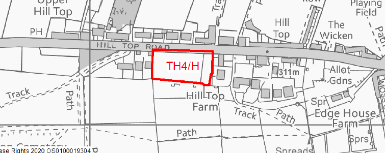
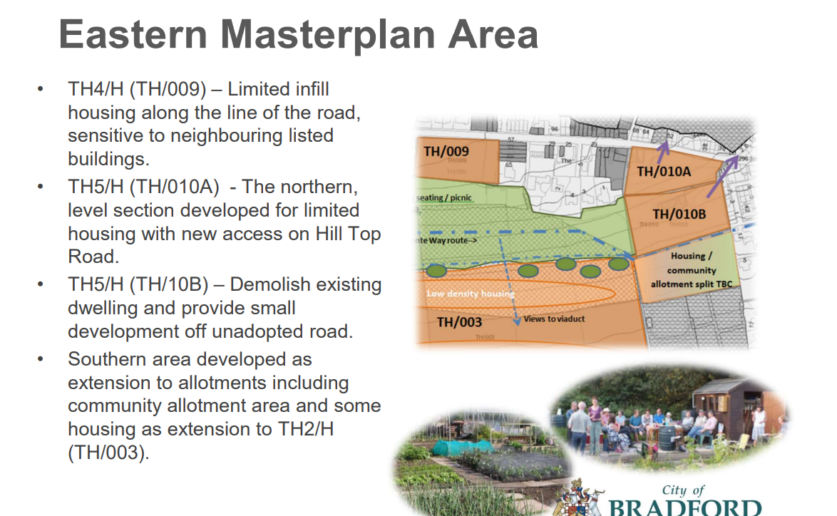
Proposed site TH/009 (previously TH4/H)
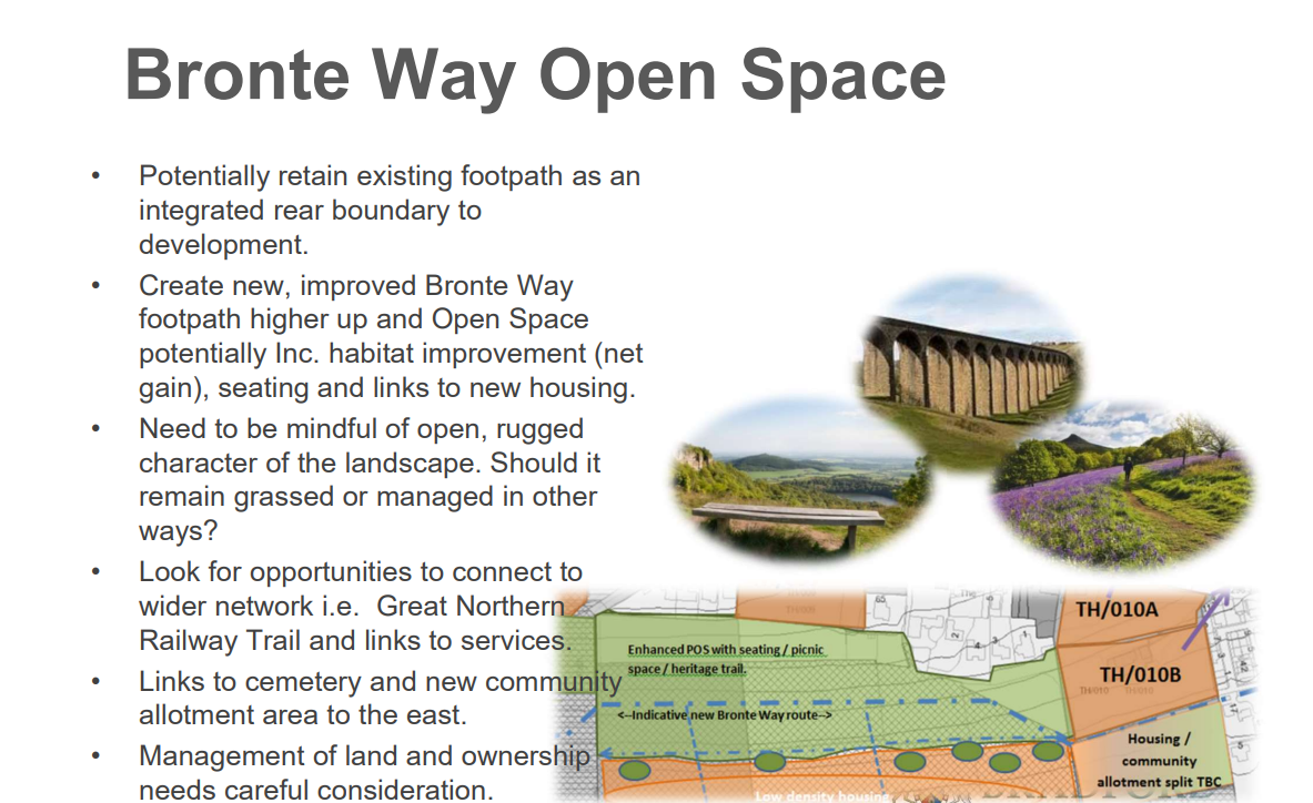
This is a field backing on to Thompson Square to the east, and extending to newish houses, to the west, on the south side of Hill Top Road. The Council’s strategic planners’ comments on that site are given in the Eastern Masterplan Area, below. The estimated number of dwellings for this site is 10. (Updated 29 May 2026)
Proposed site TH/010A and TH/ 010B, (previously TH5/H)

This land was bought from the original Abe Shaw, by Bradford Council for allotments. The land has many springs in it. Edge House Farm, in the centre of the site has recently received planning approval to be extended, with another floor. Although the Eastern Masterplan Area refers in the paragraph on TH/010B to demolishing the existing dwelling which was Edge House Farm, it is privately owned and received planning permission in October 2024 to add a storey and a loft, to become a 4 bedroomed house. The estimated number of dwellings for this site is 12. Included in the Council’s commentary for site TH/010B is the land below that area down to the allotments. It suggests that near to site TH/003 Houses could be built in part, and additional allotments in the other part. (Updated 29 May 2026)
Proposed site TH/012, (previously TH6/H)

The site of Dole and Prospect textile mills. Privately owned. The estimated number of dwellings for this site is 50. (Updated 29 May 2026)
Proposed site TH/018, (previously TH7/H)
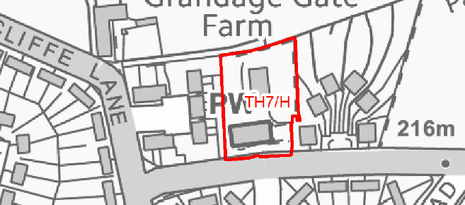
A Planning application, 23/02144/MAR, was submitted in August 2023 for 16 dwellings on this site which has now been approved. The actual number of dwellings for this site is likely to be 16, which is 3 more than the Regulation 18 preferred sites suggested. (Updated 29 May 2026)
Proposed site TH/027 (previously TH8/HC)

This site received planning permission for up to 250 dwellings on 21/8/2019, but the detailed application, which was approved on 4 June 2021, is only for 160 dwellings. The development is called Squirrel Fold. The majority of the houses now built. There are no dwellings directly under electricity cables between pylons. The estimated number of dwellings for this site was 250. (Updated 29 May 2026)
Proposed site TH/029 (previously TH9/H)

Land above Close Head Drive and Ash Tree Avenue. Believed to be privately owned. The estimated number of dwellings for this site is 50. (Updated 29 May 2026)
Sites TH/033A and TH/033B are after site TH/002A
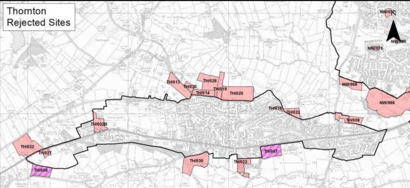
REJECTED SITES -Sites suggested by landowners but rejected by Strategic Planners. Most, but not all, are in the Green Belt. See the map below.
- Rejected site TH/002B From and including site TH/002A, from just above Close Head, off Close Head Lane to Thornton Road, including the former water treatment works, and the separate workshop south of the cemetery. The land was owned by a subsidiary of Yorkshire Water, and by a local person, with a small part owned by Bradford Council. It received planning permission in 2008 for 70 dwellings, but was not proceeded with because of problem of access to Thornton Road. The access via Close Head Lane, which runs from the bus turning circle to Close Head, was not adequate for the increased traffic. An alternative access was to set back the gates of the cemetery and run the access road from that access before the cemetery gates. That was not acceptable to the Council’s Bereavement Services department. (Updated 30 May 2027).
- Rejected site TH/005 In the Green Belt, rejected for both housing and employment use. Two fields between Cragg Lane and Squirrel Fold
- Rejected site TH/007 In the Green Belt, rejected for both housing and employment use. Two fields east of Lower Green Lane to St James Churchyard, and south of Thornton Road.
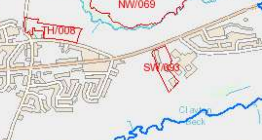
- Rejected site TH/008 Half not in the Green Belt, and half in the Green Belt. East of Allerton Lane and immediately north of 19th century dwellings from the junction of Allerton Lane and Old Road, eastwards along the north of Old Road.
- Rejected site TH/013 In the Green Belt, from the north east side of Thornton Rec, and north west side of Spring Holes Lane to 1 Spring Holes Lane. In the Green Belt.
- Rejected site TH/014 In the Green Belt from the junction of Spring Holes Lane with Back Lane, east and north of Back Lane.
- Rejected site TH/018, in the Replacement Unitary Development Plan, which was for 3 dwellings in the garden of Victoria Cottage, not in the Green Belt.
- Rejected site TH/019 In the Green Belt, a strip of land further north than rejected site TH/013, between rejected sites TH/025 and TH/028.
- Rejected site TH/020 In the Green Belt, on the north eastern side of Spring Holes Lane, opposite part of rejected site TH/013.
- Rejected site TH/021 Not in the Green Belt. A currently used site for commercial units, surrounded by site TH/027 known as Squirrel Fold housing.
- Rejected site TH/022. In the Green Belt, the first field west of the access road from Grandage Gate Farm to Upper Hoyle Ing, and north-east of North Cliffe Lane.
- Rejected site TH/023. In the Green Belt, land west of Ashfield House, east of housing on Prospect Street, and south of Thornton Road.
- Rejected site TH/025 In the Green Belt, northwards of Back Lane, to the east of site rejected site TH/019.
- Rejected site TH/028 In the Green Belt, to the north of rejected site TH/014 and the west of rejected site TH/019.
- Rejected site TH/030 In the Green Belt, a large area of and south east of the last house on Lower Kipping Lane and westwards toward Gill Lane, opposite Pinch Beck.
- Rejected site TH/032 In the Green Belt, between Well Heads and Thornton Road, opposite the western part of Squirrel Fold, site TH/027
- Rejected site SW/093 This site is not adjacent to the TH sites which all adjoin the so-called Thornton Settlement Area, but is still within Thornton. It is land between the west of Beckfoot Thornton School and the east of Leaventhorpe Hall. See map below –
(updated 30 May 2026)
