For other places click / press on the appropriate button
Lady Field Shown on the 1891 map: Back to backs, where they are now, east of Chapel Terrace, accessed from Westville Way. The field that the dwellings were built on had the name of “Lady Croft” on the 1849 Tithe map.
Lane Bottom In the 1851 census, and shown on the 1852 map: A dwelling at the junction of a lane leading to Mucky Lane and the Brighouse and Denholme Road, roughly where Willow Dene is now, but a much larger dwelling – see an extract from the 1852 map. Five families lived there in 1851. The road called Mucky Lane, which is now in Calderdale, was so named because of the poor state of the road. In 1871 the residents decided to re-lay the road themselves. They raised £75 for materials and did the labour themselves. They placed a commemorative monument on their new road, renamed Perseverance Road, which opened on 4th November 1871. The names describing the Local Board are the names of the residents who did the work. It is a Grade II Listed structure.

Lane End On the 1891 map: A block of 6 back to backs on the Thornton side of Thornton Viaduct abutting Lower Kipping Lane. Lane End continues through the entrance to The Croft on Hugill Street, turn right and there is a terrace of dwellings which make up the rest of Lane End. Numbers 7 and 9, and 11 and 13 are Grade 2 Listed buildings. The listing for 7 and 9 states: “Circa 1800-20 pair of cottages; sandstone “brick” with stone slate roofs, corniced chimney. Three light square mullion windows in squared surrounds on both floors. Squared jamb doorways each end of fronts. No 7 has a slightly later extension to west, also with 3 light square mullion window. Included for group value.” and that for 11 and 13 states: “Late C18, built as one house. Two storeys, sandstone “brick” with flush quoins. Stone slate roof with prominent shaped kneelers; corniced chimneys. Two light square mullion windows in squared surrounds. The doorway to No 13 has a gabled C19 trellis porch. Squared jamb plain doorway to No 11.” (updated 21 October 2022)
Lane Head Hole on the 1852 map. Dwellings southwest of Lower Heights Road towards the junction with Rock Lane.

Lane Side, in the 1841 census, which runs from the junction with Brewery Lane at West Scholes, to Low Lane, roughly on the north-east side is a row of cottages which were in Thornton civil parish until May in the year 2004, since which time they have been in Queensbury civil parish. Numbers 27 to 43 Lane Side are Grade 2 Listed buildings. Their Listing states: ” Circa 1820-30 row of sandstone “brick” cottages. Stone slate roofs with paired block brackets to the eaves. Corniced chimneys. Three light square mullion windows with single lights over doorways, a few have been altered. Squared jamb doorways. Included for group value.” Westwood at 45 Lane Side is also Grade 2 Listed. Its Listing states: ” Circa 1850-60 house, probably a rebuild of an earlier structure. Two storeys, sandstone “brick” with ashlar dressings. Rusticated quoins, moulded eaves cornice, stone slate roof, flanking chimneys. Symmetrical 3 bay front with revealed sash windows. Pilastered doorway with entablature. Decorated cast iron rainwater head and down pipe. Included for group value.” The Stable/Coach house to number 37 Lane Side is also Grade 2 Listed. Its Listing atates: “Circa 185O-60, may be an adaptation of an earlier barn to coach house use. Sandstone “brick”; stone slate roof with bracketed eaves and saddlestones. Small triangular ventilation openings beneath eaves and paired round headed openings to centre above segmental, grooved voussoir archway. Included for group value.” (updated 14 September 2023)
Laundry On the 1921 map, on Ashfield Road, east side in its own building north of the Great Northern Hotel.
Law Hill, on Pit Lane. In the 1841 census. Was in Thornton civil parish until the year 2004, when it was transferred to Queensbury civil parish. It appears to have had more dwellings in 1841 than exist now. (Updated 15 August 2023)
Laws Farm in the 1861 census, in that part of Thornton civil parish which in the year 2004, was transferred to Queensbury civil parish. Location probably near Law Hill. A barn to the south-west of Law Hill Farmhouse is a Grade 2 Listed building. Its listing states: “Dated 1818. Sandstone “brick” barn, with stone slate roof, standing at right angles to the farmhouse. Saddlestones to gable ends. Segmental voussoir archway inscribed with date.” (Updated 14 September 2023)
Leaside Drive From Back Lane to Hillcrest Avenue, built in the 1970s. (Updated 1 August 2023)
Leaventhorp or Leventhorpe? After much consideration I have decided to use the modern spelling of Leaventhorpe and refer to the older spellings of Leventhorp, Leventhorpe and Leaventhorp where appropriate. (9 Sept 2022).
Leaventhorpe Bar was a toll-bar or toll post on the Bradford and Thornton Turnpike (Toll) Road. In the 1841 Census 2 families lived at Leventhorp Bar. The post is shown on the map shown below Leaventhorpe Lane. That map also appears to show a building attached to the post or bar. (Updated 9 September 2022)
Leaventhorpe Grove Shown on the 1947 map as built. (Reviewed 9 September 2022)
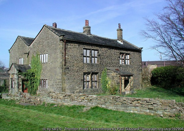
Leaventhorpe Hall is a Grade 2* Listed building. It is also on Historic England’s Buildings at Risk register. It is described in their listing as Leventhorpe Hall. The Listing states “Square late C17 house of coursed gritstone with flush quoins. Appears to have been re-roofed early to mid C18 with double pitch stone slate roof. Coupled gables to east and west with saddlestones and shaped kneelers. Stone gutter spouts to valley. C18 and early C19 corniced chimneys. Symmetrical north and south fronts with coupled, chamfered mullion and transom windows in chamfered reveals. The north front has central mullion and transom stair light. Early C19 part roofed gritstone porch with squared jamb doorway to centre of south front. East and west elevations single mullion and transom windows, some blocked. Moulded jamb doorway with 4 centred arch in squared head to west front.”
Also listed are:
- Barn to north of Leventhorpe Hall fronting road, Thornton Road BD13, Grade 2. Its Listing states “Late C18 barn probably a rebuild. Sandstone “brick” with stone slate roof. Projecting two-storey hipped roof bay facing Thornton Road with three-light square mullion window in squared surround above flush quoined barn door with ashlar lintel.”
- Barn on east side of north yard at Leventhorpe Hall, Thornton Road, BD13, Grade 2. Its Listing states “A long sandstone “brick”‘ and gritstone barn, largely a late C18 rebuild. Stone slate roof, saddlestones with kneelers. Outshut to west side.”
- Outbuilding to east of Leventhorpe Hall, Thornton Road BD13, Grade 2. Its Listing states “Mid to late C17 former dwelling with some C18 or early C19 alterations. Two-storeys, coursed gritstone with flush quoins. Stone slate roof with saddlestones. Four-light chamfered mullion windows with drip moulds on carved returns and later square mullion openings. Doorway has massive pediment shaped lintel.”
The history of Leaventhorpe Hall is given on actual page 339, which is page 392 of the digital copy of the History and Topography of Bradford with a topographical note of its parish, by John James, dated 1841. William Cudworth’s Round About Bradford, A series of sketches (Descriptive and semi-historical) of 42 places within 6 miles of Bradford, published in 1876, has 13 mentions of the word “Leventhorp”, but the main information about the Hall is given on pages 143 and 144, being pages 213 and 214 of the digital copy.
Research on other aspects of Leaventhope Hall is ongoing, so findings may be entered here out of date order, until all research is completed when they will be put in a proper order.(Leaventhorpe Hall has a long history and this entry will become a separate page. ) These are the results of online searches. I will need to consult 2 publications on Leaventhorpe Hall also. On 2nd September 1648 in the House of Commons, in respect of the “Delinquency” of Tobias Lawe of Leventhorpe the House resolved to accept the sum of £350, for a Fine. This was during the English Civil War. The extract from the House of Commons record is shown. What look like “f” are long form of “s”. The fine was also agreed in the House of Lords.

The 1841 Census shows 8 families consisting of a total of 32 people living at this address, and a further 2 families at 8 at Leaventhorp Bar. They included Worsted weavers, a woolcomber, 2 agricultural labourers, a mason, 2 farmers, of different ages, both called Richard Smith. The 32 includes several children, On the 1852 map it is shown at the junction of Leaventhorpe Lane (Thornton end) and the Turnpike Trust (New Road), the junction being in front of Leaventhorpe Hall. (Incomplete, more to be added. ( Updated 6 June 2023)
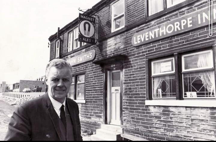
Leaventhorpe Inn, spelt “Leventhorpe Inn”, Thornton Road, at Bricks. The photo shows the Tyke in the background. (Updated 9 September 2022)
Leaventhorpe Lane On the 1852 map no road name was given, and its west junction with Thornton Road came out in the front of Leaventhorpe Hall, as shown in a copy of the 1852 map.

On the 1908 map called it was called Leventhorp Road, and is now called Leaventhorpe Lane. On the 1891 map the current alignment is shown.

The 1947 map shows the new spelling, from “Leventhorp” to “Leaventhorpe”. (Updated 9 September 2022)
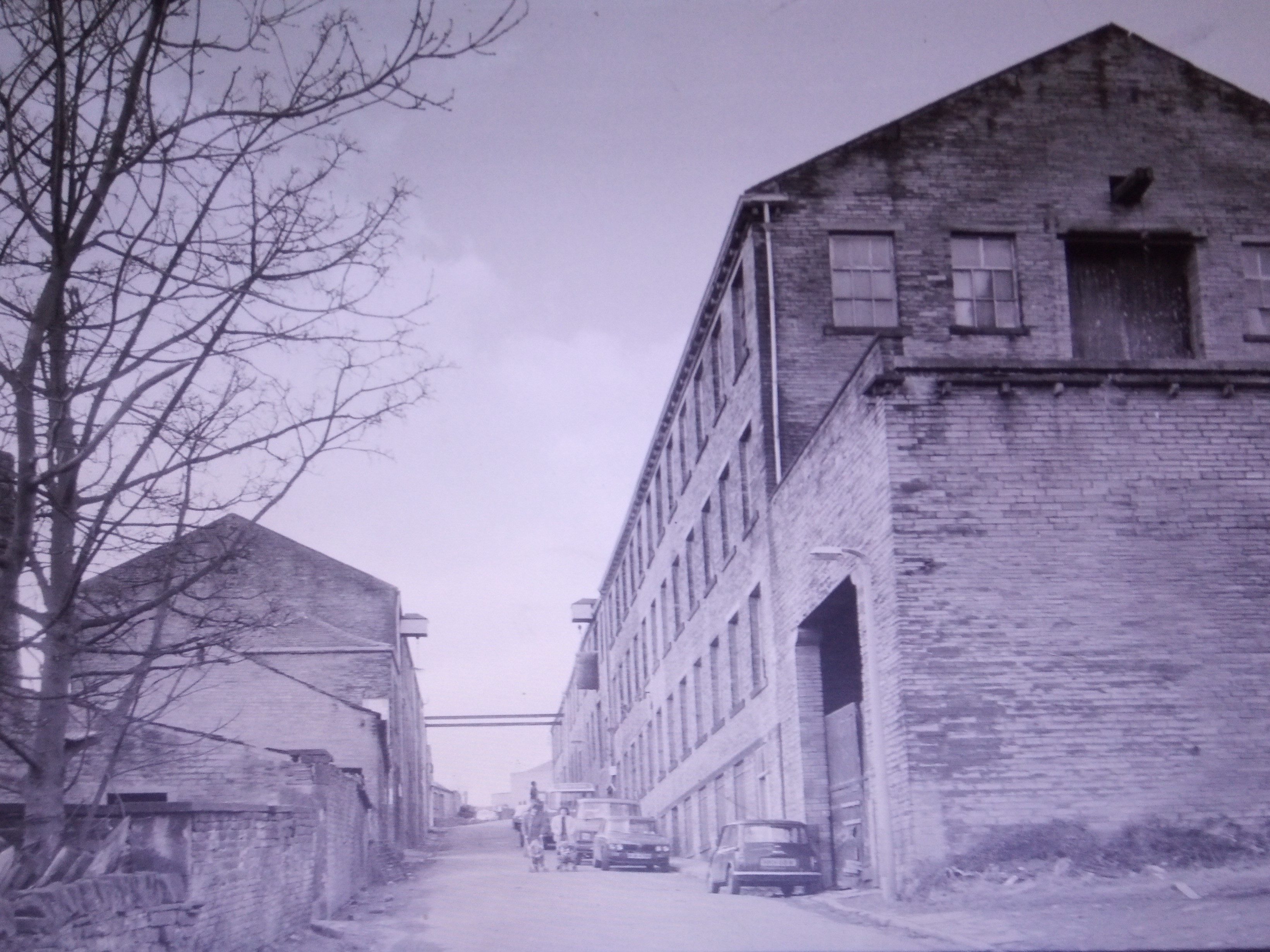
Leaventhorpe Mills On the 1852 map shown as a Corn Mill, and spelt Leventhorp, on the south side of the road. On what is now called Leaventhorpe Lane, just before Pitty Beck joins Clayton Beck. On the 1891 map there are mills both sides of the road. That to the north was a large woollen mill, and that on the south became a woollen mill. The photo is the copyright of Historic England and was taken in 1985. (Updated 9 October 2023)
Lee Top see Wilcock Lane End
(Liberal) Club On the 1921 map, On the south side of George Street, and on the corner of Firth Street, Later became Downs, Coulter’s social club, now Branwell House sports and social club. The Liberal Club had a War Memorial but it has been lost.
Little Hill in the 1851 census. There was a farm and 3 other dwellings. Off Pit Lane which was in the Thornton civil parish until the year 2004 when it was transferred to the Queensbury Civil parish. (updated 17 August 2023)
Little Hill Lane End in the 1851 census ran from Pit Lane to Little Hill Farm. There are two dwellings at the Pit Lane end, now converted to one dwelling. In that part of Thornton which transferred to Thornton civil parish in the year 2004. (updated 17 August 2023)
Little Moor Top is shown on the 1852 map. A dwelling on what is now Old Allen Road halfway between Dean Lane Head and Peat Dikes. It is now in Allerton civil parish.
Live and Let Live was the name of a Beer-house on Well Heads. In the Halifax Courier of 7 November 1868 is a public notice saying that the Halifax ad Stainland Harriers will meet at the Live and Let Live, Thornton and at the Royal Hotel, Elland, each day at “Half-past Ten o’clock.” In the Yorkshire Post of 28 November 1884 is an advertisement stating that the Live and Let Live Beerhouse is to let by the Denholme Gate Brewery. In January 1902 the Bradford Daily Telegraph has a report of a witness in a complex Divorce case. Mrs. Chappel of the Live and Let Inn considered that the woman who accompanied the defendant was his wife, (she wasn’t). (Updated 19 March 2023)
Local Government in the 19th Century Thornton was a township and chapelry in the parish of Bradford and wapentake of Morley. The township included the hamlets of Denholme, West Scholes, Headley, Leventhorpe and School Green. A Local Board was established in 1865, it became an Urban District in 1894, and in 1899 Thornton became part of the borough of Bradford. It is now part of the Thornton and Allerton Ward , which also includes Sandy Lane.
London and North-Eastern Railway, Keighley Branch show on the 1933 6″ map, formerly the Great Northern
Long Row On the 1891 map. A terrace of houses, north of Hill Top Road, as now. Numbers 2 to 26 are Grade 2 Listed buildings, Their description states ” Circa 1820-30 sandstone “brick” long row of cottages. Stone slate roofs with spaced “dentil” brackets to eaves. First floor sill band. Single and 2-light square mullion windows in squared surrounds. Squared jamb doorways. Included for interest as unaltered cottage sequence important in street picture.”
Low Fold appears in the 1851 census just after Law Hill in that part of Thornton in the vicinity of Pit Lane, which was transferred to Queensbury civil parish in the year 2004. (updated 17 August 2023)
Low Fold Farm is on the 1891 map. It is on the north-west side of Back Heights Road.
Low Lane, close to Mountain, which runs from the top of Pit Lane to Lane Side, was in Thornton civil parish until May in the year 2004, since which time it’s been in Queensbury civil parish. (updated 7 August 2023)
Low Stream Head is on the 1852 map, in Allerton civil parish. Dwellings where they are now, plus coal pits, and wells. On the 1891 map there are no coal pits or wells.
Low Town on the 1891 map, the cottages on Leaventhorpe Lane shown as New Town on the 1852 map.
Lower Bottomley Holes on the 1852 map. Between Thornton Road and Bottomley Holes, off Cragg Lane.
Lower Headley On the 1852 map, a dwelling below Headley Hall. In an unknown field at Lower Headley Farm a Mr Abraham Craven, a quarryman, found 3 either Neolithic or Bronze Age funeral urns. A short illustrated article in the Bradford Antiquary describes the find.
Lower Heights Road on the 1891 map, previously (1852) called Lower Heights. Land and dwellings to the north of Lane Head Hole. See the map shown at Lane Head Hole.
Lower Hoyle Ing On the 1852 map. Off a road, Allerton Lane, a track leading to the west half-way between School Green and Pitty Beck Bridge. An outbuilding to south side of Lower Hoyle Ing Farmhouse, is a Grade 2 Listed building. The listing states: “Mid C18 or possibly early C19. Small building, probably a bothy, but given a surprisingly architectural treatment for such a small structure. Two storeys, sandstone “bricks” with quoins. Pedimented east front with moulded coping and crowning, corniced, chimney. Pigeon holes flank bull’s eye in centre of tympanum. The first floor has two narrow round arched windows flanking larger, false, centre window with impost blocks and key to arch, painted intersecting glazing pattern. Two very small ground floor lights each side of plain doorway. The farmhouse was rebuilt late C19.”
Lower Kipping Lane from Thornton Road to Alderscholes Lane, previously known, in 1891 as Lower Kipping. All houses in Lower Kipping Lane are Grade 2 Listed buildings. Kipping Barn and Kipping House are both described above. The Listed building description of 5 Lower Kipping Lane is “Originally probably part of the Kipping House, C17/C18 origin – adapted in early C19 as a cottage pair. Sandstone “brick”, stone slate roofs, corniced chimneys. Front elevation 2, 3 and 4 light square mullion windows in squared surrounds. Squared jamb doorways, that of left hand cottage at first floor level with external flight of steps. Rear elevation retains 2 and 4 light chamfered mullion windows with later eared architrave surrounds and an oeuil de boeuf, probably contemporary with the latter.”
The Listed building description of number 7 is “C17/C18 probably part of Kipping House originally. Two storeys, gritstone and sandstone “brick”. Stone slate roof, corniced chimneys. Pentice to road with moulded chamfered jamb doorway. Two storey front at right angles with two-light chamfered mullion window next to passageway. The rear south elevation is roughcast and gabled with kneelers; two-light, formerly four- light, chamfered mullion windows.”
The description of the Listed buildings of 9 and 11 Lower Kipping Lane, the former Cub house of Headley Golf Club is: “Early C19 former cottages. Sandstone “brick”, stone slate roofs. Painted front. Two light square mullion windows on first floor, the rest altered or blocked. Squared jamb doorway. Included for group value.”
Lower Mill On the 1852 map Worsted Mill, including two mill dams, situated south of Thornton Road, where Hugill Street is now. On the 1891 map called Old Mill. The mill was bought by the Keighley Building Society in 1904. No illustration of the Mill is known to exist, but a newspaper advert in the Bradford Observer of 22 July 1875 describes it as “Four storeys high, exclusive of the attic”. The history of the mill was very much part of the lives of Jonathan Wright and his son David, and of his son-in-law, Simeon Townend The dates of 1816 and 1828 below comes from a letter to the Telegraph and Argus of 18 May 1909,written by David Wright’s great grandson, George P. Townend.
- about 1816: Mill, built for David Wright, for spinning by throstles.
- 1828 Simeon Townend introduced the first power looms run in the Thornton Valley. The inhabitants of Thornton were so against them, that he had to get his weavers from Lancashire.
- 1828. The description of goods then manufactured were wildbores, calmancoes, and dobbies.
- 1838: The Leeds Intelligencer of 13 January 1838 refers to a case of embezzling against the owner, Simeon Townend, by a salesman, Jesse Tankard. It was referred to the Quarter Sessions. He was found guilty at the Pontefract sessions and sentenced to Imprisonment for 1 month.
- 1842: August 15, (it is not clear whether this was at Lower Mill, or Upper Mill, in more recent years known as Downs, Coulter’s), during a period of Chartist assemblies and riots, known as the Plug Plot Riots when Chartists stopped work at mills by knocking out boiler plugs, thereby letting of all the steam which powered the mills. A case of conspiracy and riot was reported by the Bradford Observer on 23 March 1843. William Blakebrough and Samuel Wilson, who had been out on bail, had been charged with a Conspiracy and Riot at York Assizes. It was reported that on the evening of Monday 15 August 1842, Thomas Horner, the engine tenter to Mr. Simeon Townend, was in the yard of his master’s factory, when the prisoners came into the yard with a large crowd. Blakebrough asked Horner if he would allow them to draw the plugs, and he told them he would not. Horner went to see his master on the subject, and when he returned he said they must let the plugs alone, and he would let the steam off. Blakebrough, in the presence of Wilson, said that they would draw the plugs that night, or they would bring 10,000 people the day after. Blakebrough then knocked out one of the plugs, and Wilson followed his example. Wilson attempted to knock a third plug put but he could not do so, and scalded his foot. The prisoners in defence denied the charge, and called witnesses as to their character. They were found Guilty of the charge of Conspiracy and each were imprisoned for 2 months with hard labour.
- 1849: On the 1849 Tithe Award map it was just called a Factory, being a mill, yard, reservoir and road, etc., owned by Simeon Townend.
- 1856: An advertisement in the Bradford Observer on 1st May 1856, gave details of the Mill for sale: The mill did not find a new buyer for some years. Advert ©copyright of “Find My Past”. Further research has shown that the Mill was first put up for sale in 1840.

- About 1862; It was bought by Isaac Walton of a house in Walton Place, Thornton, (now numbers 439 to 451 Thornton Road). (according to the Telegraph and Argus of 30 September 1892, when it said it was bought by Isaac Walton, “about 30 years ago”.
- 1893 June: The Telegraph and Argus reported “I hear a bit of welcome news for the Thornton people. Mr. C. Weatherall, late manager for Messrs J. & W. Hodgson and Co., Legrams Mills, Bradford ahas taken the Old Mill, Thornton and is about to commence business on his own account as a worsted spinner there. The premises have been unoccupied since the failure of Messrs. R. J. Walton and Son, in September last.”
- 1893: By the 1893 map, the Mill pond had been changed to allow for housing on Thornton Road.
- 1904: the mill was bought by the Keighley Building Society who’s Secretary was John Hugill
- 1921: The 1921 map shows the mill demolished except for a few small buildings and some dwellings. Hugill Street terrace built on the east end of the north side. A terrace of houses had been built on Thornton Road, immediately adjacent to the Mill Pond north of the mill. (Updated 30 July, 2025)
Lower Sandal On the 1852 map, dwellings between which the Sandal Beck flows off the south side of Deep Lane. Currently, in 2022, and for many years past, though not in 1891, the first farm is Black Carr Farm and the second is Lower Sandal Farm. In 1891 Black Carr Farm was where Bar Farm now is on Brighouse and Denholme Road. (Updated 21 October 2022)
Lower Shy (Shay) in the 1861 census
Lyon Street Named on the 1891 map, from the top part of West Lane, westwards, as now. On the 1849 Tithe Map it is shown as a through road between Hill Top Lane and the northern end of the Roundfield Place part of West Lane. (Updated 22 October 2022)
Main Street, the former name of Market Street, as shown in the 1841 census. (updated 9 September 2023)
Malt Kiln In the 1851 census, a farm of 15 acres, the farmer being Eunice Bentham, widow, aged 62. On the 1852 map, a building north of Malt Kiln Lane. The first building from the Squirrel end of Malt Kiln Lane. (Updated 17 August 2023)
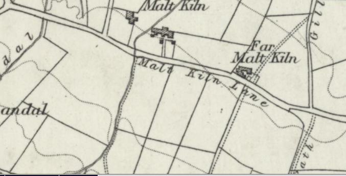
Malt Kiln Lane On the 1852 map, a lane between Headley Ley Lane and Squirrel. The 1849 Tithe award map shows 7 fields on the south side of Malt Kiln Lane, between its junctions with Deep Lane and Pit Lane. Today there are only 4, and only 2 fields have common boundaries as in 1852. The extract from the 1852 Ordnance survey map, (copied from the digitised map, copyright of the National Library of Scotland, with their permission for non-commercial uses), shows 4 fields to the south, from the “M” of Malt Kiln Lane eastwards. Theses fields are numbered on the Tithe award map, 689. 690. 691, and the larger field is 692. 689 is known in the Tithe Award as Far Malt Kiln Field, 690 as Malt Kiln Field, and both 691 and 692 as Malt Kiln. Fields 689, 690, and 691 are all of a similar size, between 1 acre, 3 roods and 16 perches, and 1 acre 3 roods and 19 perches, and all laid to grass, while the larger field, 692 is 3 acres and 18 perches and not stated as laid to grass. The three smaller fields were owned by Benjamin Thompson and let to George Crowther, while the larger field was owned by Thomas Wheatley and let to Samuel Sharp. (Updated 23 October 2022)
Maria Brontë Drive, see Gleeson development. (updated 12 July 2023)
Market Court south of Market Street just before the Library and Community Centre. 4 dwellings in a block. (Updated 23 October 2022)
Market Street, previously called Main Street. Named on the 1891 map. Significant buildings on Market Street include(d) Cloggers Row, including the Doll’s House, Cowburn Farm, Ingham’s Shuttle Factory, Thornton Mechanic’s Institute, Thornton Community Centre, Thornton Community Library, Kipping Chapel, the Brontë birthplace, the National School, Coffin End, and Kipping Sunday School, which have or will have entries in this Gazetteer. Market Street was on the old route from Bradford and became the main shopping street in Thornton from the 19th century until the last quarter of the 20th century.
For further details of all dwellings and other buildings on Market Street see “Thornton Thoroughfares” which is a new edition of two former books by local historian Michael Smith (one on Market Street and the other on Thornton Road). Thornton Thoroughfares is published by Thornton Antiquarian Society. The book may be borrowed from Bradford Libraries.
Many houses and one other structure on Market Street are Listed buildings:
- South Side:
- 11-17, Grade 2. Description: Built as “back to backs” with date plaque inscribed: J over N B 1830. Three storeys, sandstone “brick”. Stone slate roof, “brick” dentil eaves. Corniced chimneys. Elevations treated as pairs with central passageway. Plinth and sill bands to upper floors. Two light square mullion windows with single light windows above doorways, squared surrounds. Doors of 6 moulded and flush panels, rectangular fanlights, with squared jambs. Carved consoles, flush frieze with incised diamond pattern and support projecting moulded cornices. Similar rear elevation with plain doorways.
- 19 and Barn, Grade 2. Description: Built as 3 dwellings, circa 1800-30 row, the western part of slightly later build. Two storeys, sandstone “brick” with stone slate roof and corniced chimneys. The elevation to street is virtually windowless. South front has 2 light and 3 light (formerly 5) square mullion windows in squared surrounds. The barn adjoins to west, similar height and build with large ashlar lintel to doorway.
- Kipping Independent Chapel, Grade 2. Description: 1843 rebuilding of C18 chapel which replaced the original meeting house in the Barn, Lower Kipping Lane qv, chartered by Charles II in 1672. The chapel, on a rectangular plan, presents a 2 storey front of dressed sandstone “brick” with ashlar dressings. Simplified Greek Revival details. Three bays, the centre breaking forward slightly. Broad quoin pilasters, plinth, plat band, bed mould to frieze and projecting cornice broken over quoin pilasters. Hipped slate roof. Outer first floor windows have battered eared architrave surrounds. The central window tripartite with pilasters and entablature. Dated plaque set below. Ground floor has 2 light pilastered windows with entablatures and large central porch of shallow projection. Doric pilasters with rosettes to necking , deep frieze cornice and blocking course. Large double doors with horizontal moulded panels. Plain 2 storey side elevations. Galleried interior, the furnishings partly later C19.
- Railings and Gate Piers in front of the Chapel, Grade 2. Description: 1843. Dwarf stone walls with cast iron railings and battered terminal piers. Broad quoin pilastered gate piers surmounted by ornamental cast iron lamp standards.
- 45 to 51, Grade 2. Description: Mid to late C18 cottage row doubled in depth with elevations of circa 1830 to Market Street. Two storeys, sandstone “brick” with stone slate roofs; corniced chimneys. Two light square mullion windows, squared jamb doorways, altered pilastered shop front. Leading through to Bridge Street and the southern front of row, is a covered way where the change in build is evident. This C18 south front has 3 and 4 light square mullion windows with single light over doorways, all in squared surrounds. To the left of each doorway is a small round headed blind window, the head cut out of a single block.
- 53, Grade 2. Description: Corner with Ackroyd Court. Circa 1840-50, two storey sandstone “brick” house with shop. Hipped stone slate roof. First floor sill band, 3 windows in squared surrounds, the centre larger, on first floor. Two pilaster framed and corniced original shop windows on ground floor. Included for group value.
- 55 and 57, Grade 2. Description: No 55 is an early C19 small sandstone “brick” cottage with block brackets to eaves of hipped stone slate roof. Two squared surround windows. No 57 has been repointed mid C19 sandstone “brick” 4 sash windows first floor. Pilastered shop front with narrow, round headed, thin mullioned lights, fascia over. The rear elevation is of circa 182O-30 with 3 light square mullion windows and 2 single lights to centre over entrance. Squared surrounds to windows and squared jambs to doorway. Included for group value.
- North Side
- Cloggers Row, Grade 2. Description: Circa 1806 long row of 2 storey sandstone “brick” cottages. Stone slate roofs, brick chimney stacks. Majority have coupled windows with square section dividing mullion and ashlar surround to ground and first floors with single stone framed window over door. No 8 has round headed window and doorway with small block keys. Panelled doors. Date stone of 1806. Other doorways have plain stone surrounds and lintels. Market Street is part of the old road from Bradford and Nos 8 to 30 form an important introduction to the old township.
- 48, 50, and 52, Grade 2. Description: Circa 182O-30 three storey row. Sandstone “brick”. Plat bands; block bracketed eaves, stone slate roof; corniced chimneys. Single and former 3 light square mullion windows in squared surrounds to each front. No 52 retains mullions on top floor. Plain doorways with squared jambs. Included for group value.
- 54, 56 and 58 (Fern Bank), Grade 2. Description: Circa 1814 presenting a paired cottage front to road but with entrance to No 58 to side and therefore back to back in part. Two storeys, sandstone “brick”. Paired plain modillion brackets to eaves of stone slate roof; corniced chimneys. Single- and two-light square mullion windows in squared surround. Squared jamb doorways with moulded cornices on plain shaped console brackets.
- 60 and 62, Grade 2. Description: Dated 1814 with initials A over J S. A small 2 storey, 3 bay sandstone “brick” house, raised on basement. Later subdivision with side door to No 60. Stone slate roof with paired modillion brackets to eaves. Corniced chimneys. Symmetrical fenestration, revealed sashes in squared surrounds. Narrow to centre of first floor. Squared jamb doorway with rectangular fanlight; moulded cornice over on plain shaped console brackets. The entrance to No 60 has a wooden porch with small cast iron fretted brackets to lintel and cornice over.
- 2 Springfield Street, Grade 2. Description: the last sentence of the description for 2 to 16 Springfield Street, : Return front of No 2 to Market Street has small shop front and 2 light square mullion windows to upper floors. Lead rainwater head, and downpipe, dated 1819.
- Barn to the rear of number 72, Grade 2. Description: Early C19. Sandstone “brick” barn contemporary with and originally part of No 74. Stone slate roof with saddlestones. Segmental voussoir archway.
- 72 and 74, with front garden wall and railings, Grade 2*. Description: House built in 1802, home to the Bronte family 1815-20, being the birthplace of the Bronte Sisters: Charlotte 1816, Emily 1818 and Anne 1820. Numbers 72 and 74 Market Street is listed grade II* for the following principal reasons: Association: as the birthplace of the celebrated C19 novelists Charlotte, Emily and Anne Bronte; and Date: as a good example of a small, early C19 townhouse. See more under Brontë Birthplace.
- 76 and 78, Grade 2. Description: Circa 18O2 former stable/coach house to No 74 with dwelling at west end. Sandstone “brick” in deeper courses than those of No 74. Stone slate roof with block brackets to eaves. Blocked doorway. Cottage has 2 light square mullion windows in squared surrounds. Plain squared jamb doorway. Included for group value.
- 90, 90A, and 92, Grade 2. Description: Early C18 or possibly late C17 dwelling, refronted circa 1800 with mid C19 shop fronts. Two storeys, sandstone “brick” front with flush quoins. Stone slate roof, small kneeler to gable end of No 92. Two light square mullion windows in squared surrounds on first floor. Modernised shop front to No 90. Small, mid C19 pilaster framed shop windows to Nos 90A and 92. Plain squared jamb doorways. Side elevation of No 92 has more irregularly coursed gritstone. Four light chamfered mullion window on ground floor and 2 light one to first floor.
- 94, Grade 2. Description: Altered building possibly of C17 origin but refronted late C18. Sandstone “brick” with flush quoins. Gable end to road with kneelers. Higher section to rear going up Field Court with squared surround windows. Included for group value.
- 112 and 114, Grade 2. Description: No 114 formerly a pair of cottages (now includes former No 116) dated 1757; R over I S, projecting from building line of No 112. Two storeys, thin sandstone “brick”. Flush quoins. Stone slate roofs. Saddlestones with kneelers to No 112. The latter has 3 windows on first floor and one on ground floor, in squared surrounds; modern shop front inserted. No 114 has single and 2 light square mullion windows on first floor, bows inserted in original squared surrounds on ground floor. Important position in street.
- Market Street last updated (5 May 2023).

History of Market Street
- 1815, May 19 the Revd. Patrick Brontë, his wife Maria and their two young children Maria and Elizabeth arrived at the parsonage in Thornton to begin their new life.
- 1829 Prior to the building of the second part of the Thornton Turnpike (toll) Road from Bradford to Thornton, this part being from Leaventhorpe Hall to the Keighley and Halifax Turnpike (toll) road in 1829, Market Street was part of the only main road through Thornton. At that time it was called Main Street, and it continued to be called that as well as Market Street for about twenty years.
- There will be other history here.
- 2025, May 14, Camilla, Queen Consort of the United Kingdom, was driven along Market Street, where she visited, and officially opened the refurbished, and community owned, Brontë Birthplace and then met local residents and visitors. (Updated 19 May 2025)
Market Street Letter Box, in the garden wall of 62 Market Street, shown on the 1891 map (un-named), but named on the 1908 and 1921 25″ to the mile maps. (Updated 24 October 2022)
Marley House, off Marley Lane, West Scholes, is a Grade 2 Listed building. Its Listing states: “Circa 1800-20 two-storey sandstone “brick” house with 3 bay south front. Stone slate roof with saddlestones, corniced chimneys. Two light square mullion windows in squared surrounds to rear elevation. C19 sashes to south with thin ashlar lintels and block sills. Pilastered doorway. Gable ends have Venetian windows.” (Updated 16 September 2023)
Mary Street on the 1891 map. A street of back to backs, east of, and parallel to Firth Street, from George Street northwards. (Updated 2 November 2022)
Mavis on the 1852 map, was a dwelling further up Cocking Lane on the right. Mavis is a colloquial name for a song thrush. On the 1849 Tithe Award the house and fields around it were called Morphas, probably a written form of a Yorkshire accent. Now known as Mavis Farm. (Updated 2 November 2022)
May Avenue Built in the 1920s with the rest of the estate then known as the Council estate. A cul-de-sac from the northern side of Springhead Road. (Updated 3 November 2022)
Middle Sandal in the 1861 census. (Updated 18 August 2023)
Milestone on School Green shown on the 1891 map, Bingley 6 (miles), Halifax 6. This no longer shows locations. Prior to the 2nd WW the locations were chiselled off, presumably to confuse any invading enemy.
Milestone on Thornton Road shown on the 1905 map opposite the middle of the present group of houses on Thornton Road opposite Ashfield House Halifax 7 miles, Bradford 4. (Updated 3 November 2022)
Milestone on Thornton Road shown on the 1905 map east of the current junction with Leaventhorpe Lane: Halifax 8 Bradford 3 (Updated 3 November 2022)
Millbeck Close off Leaventhorpe Lane east of Leaventhorpe Grove. (Updated 3 November 2022)
Mills, Corn see Thornton Corn Mill There was also a Corn Mill at Leaventhorpe, of which there is little information, but see Leaventhorpe Mills
Mills, Textile There will be an entry for each textile mill. These will include Albion Mill, Dole Mill, Excelsior Mill, Leaventhorpe Mills, Lower Mill which became Old Mill, (or Walton’s Old Mill), Moscow Mill, Prospect Mill, Shawl Mill, Upper Mill which became Thornton Mills (also known from 1901 to 2002, as Downs, Coulter’s),
Of the textile mills the first built was Lower Mill in the 1820s, Prospect Mill in the 1830s and expansions in successive years, Dole Mill from the 1840s, Upper Mill (Thornton Mills) also from the 1840s or 1850s. More research is planned to be done on all the mills. Ash Tree Shed, which became Excelsior Mills, Moscow Mill, Shawl Mill and Albion Mill were built later. (Updated 10 October 2023)
Mission Room In 1891 shown where Abe Shaw’s now is at the bottom of Hill Top Road. Continued to be a mission room until at least 1905. Connected with the Parish Church of St. James. (Updated 10 October 2023)
Mitchell Hall Farm is shown on maps up to 1949 as Mitchell Hall. It was located 100 yards off Cockin Lane between Mavis Farm and Green Head farm towards Yews Green. On December 24 1908, a female infant child’s body was found in a boiler in the farmhouse, which building in the newspaper report of the inquest (in the Shipley Times and Express of 1 January 1909) was described as “very much out of repair and unoccupied for a number of years.”. The farmhouse no longer exists, but there is a walled track to its location, just a little further up Cockin Lane after the entrance drive to a house called Cranmore. The farmhouse was where the agricultural shed is now. (Updated 14 August 2024)
Moor Cock Farms on the 1893 map, previously (in 1852) known as Moor Cock. Dwellings, Higher Moorcock Farm and Lower Moorcock Farm, on a lane between Black Dyke Road and Ten Yards Lane, north of The Roughs. (Updated 4 November 2022)
Moor Delf on the 1852 map A quarry below Thornton Heights Quarry (sandstone), accessible from Upper Heights Road. (Updated 4 November 2022)
Moorroyd, a farm in the 1841 Census. Off Pit Lane. In Thornton civil parish until the year 2004, now in Queensbury civil parish. (Updated 16 August 2023)
Moor Royd Gate, (More royd Gate, in the 1841 Census). A farm off Pit Lane. In Thornton civil parish until the year 2004, now in Queensbury civil parish. Moor Royd Gate Farmhouse and Integral Barn are Grade 2 Listed buildings. Ther listing states: ” Late C17 farmhouse with barn under same roof. Two-storeys, coursed gritstone the farmhouse rendered; flush quoins to barn. Stone slate roof. The house has three 3 light, originally 6 light, chamfered mullion windows with an 8 light central window. Drip moulds over on ground floor. Four centred arched doorway with squared head.” (Updated 14 September 2023)
Morphas see Mavis
Morton Villa Farm on the 1893 map, north of Close Head Lane (now called Well Heads). The farm is now in Denholme civil parish. Updated 1 December 2022)
Moscow on the 1852 map. Dwellings opposite the junction of Ten Yards Lane and Half Acre Road. The 1841 Census lists 7 households at Moscow, the houses being unnumbered. In the 1861 Census 8 unnumbered houses are listed. In the 1881 Census there were 13 households at Moscow, numbered 24, 25, 26, 27, 28, 29, 30, 31, 32, 33, 34, and 35. There were 2 families at no. 32. In the 1891 Census there were 8 households at numbers 55, 57, 63, 67, 71, 73, 75 and 77. The inhabitants of 67 Moscow in the 1891 Census, were the same family as lived at 27 Moscow in 1881, indicating a re-numbering of the Moscow houses. between 1881 and 1891.
The Yorkshire Post of 2 February 1895 reported on a fire at Moscow Mill. “A fire took place early yesterday morning at Moscow Mill, Thornton, near Bradford, on the premises of Mr. A. Atkinson, commission weaver. Owing to water in the vicinity being frozen, the whole premises were completely wrecked before anything could be done. The mill was a small one-storey structure, and the damage will amount to some hundreds of pounds, which, however, is covered by insurance.“
There was a stone quarry at Moscow, owned by Mr. Richardson Jennings. The will of Mr. Jennings was given in the Shipley Times and Express of 24 April 1908. It reads “The will was proved also of Richardson Jennings of Spring View, Thornton, Bradford, in business at Moscow Quarries, Thornton and a stone merchant, a (Liberal) member of the Bradford City Council, a member of the Thornton Joint Hospital Board, Trustee of the United Methodist Free Church, Egypt, Thornton, and Trustee of the Independent Order of Rechabites, prominently connected with both the Thornton Cricket and Football Clubs, who died March 14, left £3,918 gross, with net personalty (sic) £2,654. Probate of the will has been granted to Foster Pickles of Pikeley Farm, Allerton, Textile Teacher, and his son William K. Jennings of 2 Back Albert Street, Thornton, quarryman.”
On 18 January 1937 the Yorkshire Post reported on the Annual Exhibition of the Yorkshire Federation of Art Clubs at Sheffield Art Gallery. One painting displayed was by Percy Monkman, entitled “Moscow, near Thornton”, which the Post described as “achieving a three dimensional unity“. (Updated 1 December 2022)
Moss Street on the 1893 map. Also shown in the Census in from 1891 onwards. The earliest reference found is a newspaper advertisement from the Bradford Observer of 12 August 1882 advertising the sale of a Cattle Spice business belonging to the late William Horsfall of Thornton. Potential purchasers needed to contact Mary Horsfall of 6 Moss Street, Thornton. Moss Street is between Reservoir View and houses on Hill Top. West side a terrace of dwellings. East side back to backs with Cliff Street. (Last updated 2 December 2022)
Mount Pleasant (1) was an alternate name for cottages at upper Hill Top. (Updated 8 August 2023)
Mount Pleasant (2) was the name of terraced houses in Mountain, which until the year 2004 were in Thornton civil parish. They were demolished in about 1970s. (Updated 8 August 2023)
Mountain in the 1841 census. Parts of Mountain were in the Thornton civil parish until the year 2004, when they were transferred to Queensbury civil parish. (Updated 15 August 2023)
Mountain Ash Inn, 35 Back Lane. In the 1871 Census Isaac Dobson lived there and was a Beer seller, in 1881 he was described as a Beer House Keeper. In 1891 he was still there and the property was called the Mountain Ash Beerhouse. In 1901 his widow, Frances, aged 77 had taken over at what was then called the Mountain Ash Inn. She was still there in 1911, aged 87 as the Inn Keeper. In 1921 Ralph Feather was the Landlord, and in 1939 Harry Kellett described himself as Publican of the Mountain Ash Inn, as well as a Fitter’s Labourer (Heavy Work). More research needed to see when it closed, which was before the 1970s when it was the home, and private house. of Charlie and Betty Shimbles. (updated 20 February 2023)
Mountain Eagle was a Public House in Mountain whose name changed in 1983 to Mad Ma Jones. It, and adjoining buildings have ben converted to housing. The Mountain Eagle was part of Thornton civil parish until May in the year 2004, when it was transferred to Queensbury civil parish. (Updated 8 August 2023)
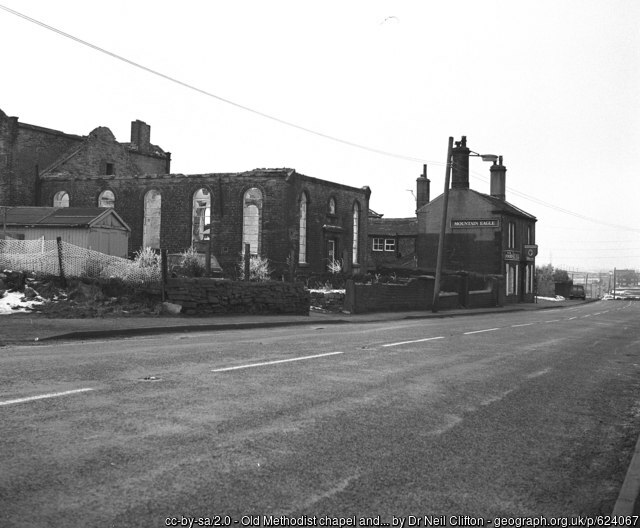
Old Methodist chapel and the ‘Mountain Eagle’, Mountain
Mountain End in the 1851 census. On the north-east side of the Brighouse and Denholme Road between Pit Lane and the Queenshead civil parish, in that part of Thornton which transferred to the Queensbury civil parish in the year 2004.
National School on the 1852 map. The earliest reference found is of a Grand Miscellaneous Concert held at the National School on the evening of Easter Tuesday, April 5th 1836. The 3 soloists were Mr. Cudmore “of the Manchester Concerts” who was billed to give a “Concerto on the violin”, Mr. Greenwood who would give a concerto on the Piano Forte”, and Master Phillipps, “The Infant Trumpeter, only eight years old, patronized by the Royal Family, will give two concertos on the Trumpet.”
The school later became Thornton Church First School, and at the reorganisation of the education system in the 1990s, closed and was converted into dwellings (Now known as Ellingham Court). (Last updated 4 December 2022)
Nettle Hall Farm, known as Nettle Hole in the 1851 census and the 1852 Ordnance Survey map, a farm of 25 acres, including 3 dwellings, one of which was empty in 1851, situated south of Little Hill Farm, in that part of Thornton civil parish until May in the year 2004, when it was transferred to Queensbury civil parish. (updated 17 August 2023)
New Close On the 1852 map. A group of dwellings to the south-east of Bottomley Holes, accessed from the Brighouse and Denholme Gate Turnpike Trust. (Updated 8 December 2022)
New Halifax In the 1841 Census. According to a 19th century local historian it was the original name of Havelock Street. Censuses of New Halifax exist for 1841, 1851 and 1861, for Havelock Street from 1871 onwards. (Updated 28 February 2023)
New Houses in the 1861 census. See Hougomont
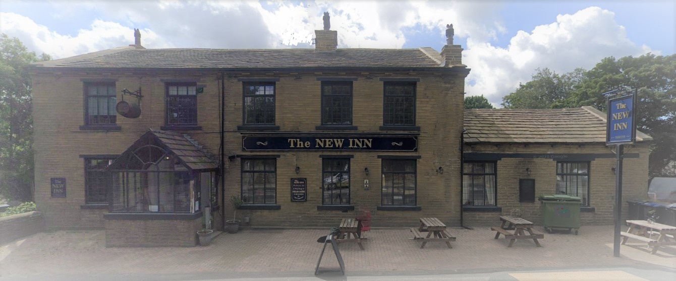
New Inn Thought to be so named because it’s on the new Turnpike Trust, Thornton Road. At the rear of the New Inn was a bowling green, on which Alan Court was built. In the 19th century the Inn was often used for the auction of property, a place tickets for functions could be bought, and the meeting place of the local “court” of the Ancient Order of Foresters. Inquests of people who died accidentally were also held in the public houses of Thornton. The earliest newspaper reference to the New Inn was an advertisement stating “At the house of Mr. Scott, the New Inn, in Thornton, on Friday the eleventh day of February next, at two o’clock in the afternoon, … the following very valuasble properties at Schoobridge, Malt Kiln, and Thornton Height,” will be auctioned. The year was 1831, less than 2 years after the extension of the turnpike road, from Leaventhorpe Hall to the Keighley and Halifax road, had been built. (Updated 26 June 2023)
New Mill On the 1852 map this was shown as New Mill, a Worsted Mill, which later became called Thornton Mills. In the history of the Kipling family there’s a history of both the Downs family and the Foster family, entitled Yorkshire Farms and Mills. The original mill was built by Simeon Townend. in 1837. It was also known as Upper Mill, but during Simeon’s lifetime it was renamed Thornton Mills. Simeon died at an early age, and the mill passed to his sons George and Wright Townend. At an, as yet, unknown date, they joined with Theophilus Peel. For some time up to June 1900 the mill was owned and run by Sir Thoephilus Peel, who had been made a Baronet in 1897. On 16 June 1900 the Bradford Daily Telegraph reported: “All the hands, (over 300), employed by Messrs Peel Bros and Co, manufacturers Thornton Mills, received a letter from Sir Theo Peel, Bart., head of the firm, yesterday, stating that owing to ill-health, and acting on his doctor’s advice, he is stopping the Thornton Mills, on June 30th inst. He, however, is removing part of the machinery to Globe Mills, Bradford, and promises to employ as many Thornton people as possible.” The Bradford Daily Telegraph of 11 February 1901 reported: “Thornton Mills, which up to last July were run by Messrs. Peel Bros., have been purchased by Messrs Downs, Coulter, and Co., of Pudsey and Dudley Hill. It is expected that the starting of the mills will find employment for some 400 hands. Messrs., Downs, Coulter, and Co. will remove their entire business from Pudsey and Dudley Hill.” to be continued. (Updated 20 April 2024)
New Pit (Coal) (is shown on the 1891 map, on the south side of Thornton Road just up the road from Pearson Place, in the current vicinity of Myers building supplies. (Updated 5 Jannuary 2023)
New Road was the name given to Thornton Road to distinguish it from what is now called Old Road. Prior to 1826 anyone wanting to go from Thornton to Bradford went via Kipping Lane, Market Street, Old Road, which began as the continuation of Market Street and went to Leaventhorpe Hall, and then onwards down what is now Leaventhorpe Lane to what is now Thornton Old Road, and onwards to Bradford. What we know as Thornton Road didn’t exist until 1826 up to Leaventhorpe Hall, and the section from there to what we now know as the A629 wasn’t built until 1829. The New Road to Thornton was built as a Turnpike Road. See further details of local Turnpike Roads here. (Updated 6 January 2023)
New Road Congregational Chapel and separate Sunday School, Built in 1866. East of Chapel Terrace, in what is now known as Kipping Gardens. The 1905 map shows the Sunday School which by 1921 had been moved to face Kipping Lane. The Chapel closed down in 1967 and was then used by a company as a warehouse. Following a major fire, the building was demolished in 1982.
(Updated 6 January 2023)
New Royd Gate, in the 1841 Census, off Pit Lane. It was part of Thornton civil parish until May in the year 2004, when it was transferred to Queensbury civil parish. New Royd Gate Farmhouse and Integral Barn are Grade 2 Listed buildings. Their listing reads: ” Circa 1800 farmhouse and barn of sandstone “brick” under a stone slate roof. Saddlestones with kneelers and coursed chimneys. Three light square mullion windows in squared surrounds. Squared jamb doorway. Rear outshut. Segmental archway to barn.” (Updated 14 September 2023)
New Town The name given on the 1852 map to a row of cottages on what is now Leaventhorpe Lane, opposite what is now Beckfoot Thornton School playing fields. Later called Low Town. See the maps of 1852 and 1891 shown under Leaventhorpe Lane, below. On the 1849 tithe map it was called Providence Row. The row of cottages still exist but are not known by any name. (Updated 6 January 2023)
Nicholas Street, shown in the 1841 Census. Renamed Prospect Street as it led to Prospect Mill. (updated 23 July 2023)
Nock, (or Nook), in the 1841 Census. Currently location not known, probably close to Clough. The occupants will be checked in later censuses and the tithe award. In Thornton civil parish until the year 2004 when it was transferred to Queensbury Civil parish. (Updated 16 August 2023)
North Cliffe is shown on the 1891 map, and is a house and gardens at the start of Cliffe Lane on the right. The earliest reference I’ve found to North Cliff (without the final “e”) is from February 9 1874 when the occupant, John Hindle, Esq., declared himself as supporting the Liberal candidates in the Parliamentary Election. The Bradford Observer of 2nd May 1877 declares the names of the 7 men elected to the Thornton School Board. They include Henry Edward Foster of North Cliffe, Thornton, a manufacturer. (Updated 20 February 2023)
North Cliffe Avenue was built in the 1920s as part of the Thornton Council estate. It first appeared on the Ordnance Survey map of 1933, running from Springhead Road to North Cliffe Lane. (Updated 6 January 2023)
North Cliffe Close, a short cul-de-sac from North Cliffe Drive, northwards.
North Cliffe Drive from North Cliffe Lane to Springhead Road.
North Cliffe Grove, a short cul-de-sac from North Cliffe Drive, northwards.
North Cliffe Lane, first named on the 1891 map, from Old Lane to Sapgate Lane.
Oakhall Park From Leaside Avenue to Staverton Grove and Cliveden Avenue, built around 1999-2000. (Updated 26 April 2023)
Old Allen Corner shown on the 1852 map, a triangular piece of moorland between what is now the east of Tewitt Lane and the north of Black Dyke Lane. (Updated 6 January 2023)
Old Allen Slack shown on the 1852 map. A slack is a soft wet area of low lying land that sinks underfoot It was north of the junction of Black Dyke Lane and Old Allen Road. (Updated 6 January 2023)
Old Lane shown on the 1893 map. This was on the pre 1829 route to Thornton. The road from Thornton Road through School Green to (unnamed) Market Street. Now called Old Road to Brooklands Avenue, and Brontë Old Road from Springhead Road to Market Street. Houses were built in the 1920s on that part of Old Road around the Brooklands Drive to the Springhead Road junction with Brontë Old Road. Also see Old Road (updated 7 January 2023)
Old Mill (woollen) For history see Lower Mill
Old Road Prior to the building of the Bradford and Thornton Turnpike Road, the main road to Thornton was via what is now known as Thornton Old Road at Fairweather Green, which continued along what is now largely Leaventhorpe Lane via the front of Leaventhorpe Hall and onwards along Old Road to Market Street. The first part of the Turnpike Road was built from Bradford to Leaventhorpe Hall in 1826, and from there to the Keighley and Halifax Turnpike Road, (now known as the A629) in 1829. The turnpike became the New Road through the village. When the Thornton Council estate was built in the 1920s, Old Road was re-aligned to terminate at Brooklands Avenue. Council houses were built on part of the Old Road, and the most westerly part which had had Council houses built on it, became Brontë Old Road. The Council Houses had been numbered 180 to 212 Old Road, but became numbers 180 to 212 Brontë Old Road. The private houses on Brontë Old Road were not built until the 1930s. (Updated 14 January 2023)
Ox Heys On the 1852 map called Ox Hey’s Originally a farmhouse opposite Westfield House. Heys is Old English for an enclosed field or animal feeding stalls. It is a Grade 2 listed building. The Listing states: “Latter part of C17. A 2-storey sandstone or gritstone farmhouse, rendered front. Stone slate roof. Long south front with 3 windows: 3 light and 4 light on first floor with chamfered mullions. Six light similar windows with drip moulds on ground floor. Three cell plan, outshut to rear.” (Updated 14 Januaey 2023)
Ox Hey Meadows a short cul-de-sac eastwards off Chat Hill Road. (Updated 14 January 2023)
Packington Street Shown on the 1891 map, named on the 1933 map. Off Upper Heights Road. (Updated 18 January, 2023)
Patrick Brontë Court, see Gleeson development. (updated 12 July 2023)
Pearson Place Shown on the 1891 map, but is of an earlier date. There were 3 families living there in the 1881 Census, including a Joseph Craven, Gentleman, with his mother and his siblings, and a John Cross, a Superintendent Police Sergeant. The earliest reference found to Pearson Place was in a newspaper report of the Thornton Local Board in 1871. Dwellings on the west side of Thornton Road, west of the railway cutting to the tunnel to Denholme, attached to Shawl Mill. (Updated 25 February 2023)
Peat Dykes shown on the 1852 map. A dwelling at the junction of Old Allen Road with the road leading to Low Stream Head. (Now in Allerton Civil Parish) Pear Dykes Farmhouse and integral barn are Grade 2 listed buildings. The listing states “Circa 1830 farmhouse with 2 light square mullion windows and barn under same roof with segmental archway. Sandstone “brick” with stone slate roof and corniced chimneys. The windows and doorway have squared surrounds and jambs.” (Updated 23 January, 2023)
Peel Street (1905) built on east side as now, and named. Most likely named after Theophilus Peel, an entrepreneur and owner of Upper Mill / Thornton Mills from 1865 to 1900. In the 1897 Queen’s Jubilee Honours, he became Sir Theophilus Peel, baronet. (updated 30 November 2023)
People, There is now an index of people, as yet uncompleted, but publicly viewable. There is a separate index of those who died as a result of their involvement in WW1 and WW2, or on rolls of honour. (Updated 12 April 2024)
Phoenix Cottage adjoins Little Hill Farm, off Pit Lane in that part of Thornton which was transferred to Queensbury civil parish in the year 2004. (Updated 17 August 2023)
Pinch Beck 1. Stream flowing from its source between Thornton Road and Cragg Lane, further west than its current source, running into Green Lane Beck east of Green Lane. See also a walk centred around Pinch Beck plus High Birks Beck and Hole Bottom Beck organised by the Friends of Bradford’s Becks. (Updated 14 February, 2023)
Pinch Beck 2. A terrace of houses alongside the stream on Alderscholes Lane. Numbers 2 to 22 are Grade 2 Listed buildings. Their official record reads: “Long row of circa 1800-20 cottages. Two storeys, sandstone “bricks”. Stone slate roof with “dentil” brackets to eaves. Corniced dressed stone chimneys. Two light and single light squared stone framed windows with square mullions, some removed on ground floor. Plain squared stone doorways.” (Updated 14 February 2023)

Pinfold 4 families lived at Pinfold in 1841. The next entries in the 1841 census are for West House and Spring Hall, which suggests that Pinfold was near to those two houses on West Lane. (Updated 7 May 2023)
Pit Lane runs from the junction of Malt Kiln Lane and Upper Headley Lane, to the Brighouse and Denholme Road. The lane, was until the year 2004 part of Thornton civil parish. It transferred to Queensbury in that year. The pits which gave it its name were at the southern end of the lane north-east and east of Law Hill. The Thornton Tithe map has 4 fields in that area, with fieldnames indicating pits, number 252 is called Upper Pit Field, 253 is called Pit Field, 258 is Upper Coal Pit Field, and 259 is Lower Coal Pit Field. In 1849 they were all laid to grass, the pits having been closed, either decades or centuries before. (updated 7 August 2023)
Pit Lane Bottom in the 1871 Census, 5 famiies and 1 uninhabited dwelling. It was, until the year 2004, part of Thornton civil parish. It transferred to Queensbury in that year. (Updated 21 August 2023)
Pitty Beck forms the boundary between Thornton and Allerton civil parishes, from its source to where it joins Clayton Beck, south east of Leaventhorpe Lane. After it joins Clayton Beck it’s named Middle Brook, hence Middlebrook Crescent and adjoining similarly named roads. A walk to the source of Pitty Beck is referenced on the Walks page, which includes part of Old Allen Road and Low Stream Head which are in Allerton civil parish. (Updated 14 February 2023)
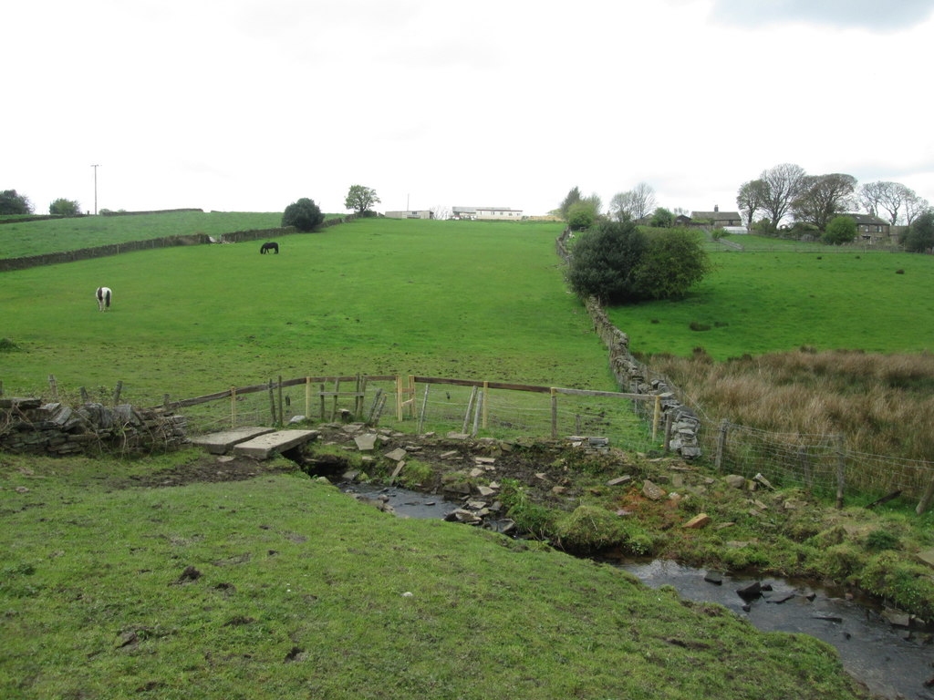
Footbridge over Pitty Beck looking towards Upper Allerton Green
© Copyright John Slater and licensed for reuse under this Creative Commons Licence.
Playing Fields The 1933 map shows playing fields on the east side of Royds (sic) Street. (Updated 14 February 2023)
Police Call Box (1933) 1. On Hill Top Road, at the corner of the road leading down to what is now Edge House Farm. 2. On Thornton Road on the west side of the pedestrian entrance to the station.
Police Station A report in the Bradford Observer, dated 27 September 1873 reads “That a plot of land, situate at Thornton, near Bradford, in the East Morley Petty Sessional Division, containing 669 square yards, belonging to Theophilus Peel, Esq., be purchased for a Police Station.” This was a decision of the West Riding Quarter Sessions. The Police Station is now a private dwelling, number 1 George Street. (Updated 26 January, 2023)
Post Office on the 1852 map, on the un-named Market Street. (1905) In the vicinity of the bottom of High Street and the top of Fountain Street. (1933) Opposite Chapel Street Methodist Church,
Priestley Street The first reference found is the 1871 Census. Runs from Thornton Road to Enderley Road. Numbers 2 and 4 Priestley Street are Grade 2 listed. The listing states: Early C19 cottages back to back with and forming the south end of South Square. Three-storeys, sandstone “brick”. Stone slate roofs, 2 light square mullion windows in squared surrounds, squared jamb doorways. Included for group value.” Numbers 3, 5 and 9 Priestley Street, originally numbered 1-11, are also Grade 2 listed: Their listing states: “Includes Nos 379A and 381 Thornton Road. Early C19 cottage row stepped down hill and increasing from 2 to 3 -storeys with slope. Back to back with Nos 2 to 10 (even) Friendly Street and part of the same development which includes South Square dated 1832, sandstone “brick”, stone slate roof, corniced chimneys. Single and 2 light square mullion windows in squared surrounds. Squared jamb doorways. The former No 1 shares south gable end return with No 2 Friendly Street. The hipped roof end facing Thornton Road (No 381) comprises 2 former 2 bay fronts with console corniced doorways, balancing No 373 Thornton Road on corner of South Square. Included for group value.” (Updated 16 February, 2023)
Prospect Mills (Worsted) The site was first used around 1831 by Joshua Craven as the centre of a putting-out system, and developed as a mill from around 1848. The first mill building, the large mill, was in existence by 1849 and the first warehouse, dated 1849, followed soon after. Craven continued to buy up plots of land to accommodate his growing business, and by 1851 the firm was described as a worsted manufactury employing 240 people. The business continued to expand, with the small mill built in around 1850-60, and the second warehouse fronting the road in 1855. The firm of Joshua Craven & Son continued until 1875, when the buildings were bought by Adolphus Getz of Bradford, and subsequently by others until at least 1929. South of Thornton Road, where currently there’s the brownfield site, after a series of unexplained fires destroying the mill, when empty, in c. 2015-7. Remaining sections of Thornton Mill were in 2017 highlighted in Historic England’s publication: “Engines of Prosperity: new uses for old mills”, especially page 62.

Prospect Street Formerly called Nicholas Street. Date when changed not known, but after the 1841 Census. It runs south from Thornton Road, a terrace of houses on its east side, originally buildings connected with Prospect Mills on the west side. Numbers 4 – 14 Prospect Street are Grade 2 listed buildings. Their listing states: “Circa 1840 row of mill cottages, stepped down hill, and part of the Prospect Mill complex. Two storeys, sandstone “brick”. Stone slate roofs with shallow eaves brackets; corniced chimneys. Two-light square mullion windows, a few altered. Plain squared jamb doorways.” Updated 23 July 2023)
Providence Row On the 1849 Tithe Map this was a row of cottages on the road which is now called Leaventhorpe Lane. On the 1852 O.S. map the area was called New Town, and on the 1891 O.S. map was called Low Town. It was still called Low Town on the 1933 O.S. map but later maps didn’t give any name. Despite the dates so far given, in 1841 the Bradford Observer of 4th March reported that on the previous Thursday, Hannah, aged 28, the wife of William Holmes of Low Town, Thornton, had died, (Updated 15 March 2025)
Providence Terrace, called Providence Row in 1891. Built with back-to-backs shared with Vine Terrace and James Street. Renamed by 1905. A cul -de-sac north of Thornton Road. (Updated 20 February 2023)
Public Houses. There will be an entry for each Public House, (including ale-houses, inns, taverns, and hotels). Currently these include: Ashfield Inn, Barrack(s) Tavern, Bay Horse Inn, Black Horse, Blue Boar, Brown Cow (Keelham), Bull’s Head, the Cavalry Inn, the Copper Kettle (Keelham), Crown Inn, the Fawthrop Hotel, the Friendly Inn, the Great Northern Hotel, Green Mount Inn, High Field Top Inn, (in the vicinity of Alderscholes), Hill Top, Mountain Ash Inn, New Inn, Leventhorpe Inn, Live and Let Live Inn, the Ring o’ Bells, the Rock and Heifer Inn, Robin Hood Beerhouse (Back Heights), School Green Hotel, Springfield Hotel, Sun Inn, the Union Hotel, Victoria (Keelham), The Wellington, and the White Horse (now in the parish of Denholme). Plus others to be found. (Updated 5 May 2023).
Queensbury civil parish has, since the year 2004, included the following roads, previously in Thornton civil parish:
- Brewery Lane, West Scholes
- Brighouse and Denholme(gate) Road, in parts, on the south side from and including Snug Cottage, Mountain, westwards, to the Calderdale boundary close to the Raggalds Inn, including Hillside Place and Mount Pleasant; on the north side from Sandal eastwards to parts of Mountain, including Grand View, and Harmony Place.
- Cockin Lane on the right-hand side only, after Mavis Farm house to Yews Green, Green Head farm and up to Brewery Lane.
- Hougomont off Low Lane.Laneside, northern side only.
- Low Lane from Pit Lane to Laneside, north side from Laneside, westwards to the bend in the road, both sides after that.
- Marley Lane, West Scholes.
- Pit Lane from the junction of Headley and Malt Kiln Lanes and the Brighouse and Denholme Road.
Rag Row was the original name of Bridge Street . Rag Row appears in the 1841 and 1851 censuses. The Bradford Observer of 24 October 1867 reported at the meeting of the Thornton Board of Health that a complaint had been made about the state of pig-styes in Rag Row, belonging to Mr. James Pearson which were nuisance and injurious to health. The matter was referred to the Sanitary Committee. (updated 15 March 2025)
Raggalds Bar, in the 1851 census on the Brighouse and Denholme Turnpike Road. The Toll post, or Bar, coming from Keelham was just before the junction with Perseverence Lane, in that part of Thornton which transferred to Queensbury civil parish in the year 2004. Raggalds Inn, itself, is now in Calderdale, but in the 1841 census was in Thornton civil parish. The 1893 Ordnance survey map (25″ to the mile” shows the boundary between what is now Bradford and what is now Calderdale), cuts through buildings in the Raggalds Inn. (updated 17 August 2023)
Raggls in the 1851 census. The person writing up the census writes what he hears. In 1851 there were 5 families here, in that part of Thornton which transferred to Queensbury civil parish in the year 2004. Raggalds is identified on the 1892 map as dwellings on the north side of the main Brighouse and Denholmegate road opposite the Raggalds Inn. (Updated 18 August 2023)
Recreation Ground (1905) To the north of The Wicken
Reservoir on the 1892 map south of Reservoir View. It belonged to Thornton Local Board Water Works. On the 1908 map it’s shown as belonging to Bradford Corporation Water Works. (Updated 15 April 2023)
Reservoir View is shown on the 1891 map where it is now. A terrace of all through houses backing on to open land.
Ring o’ Bells, a public house, for many years. Then a gastro pub. Currently closed, but likely to re-open with a new tenant. Formerly it has been said to have been a Wesleyan Methodist Sunday School. At 212 Hill Top Road. (updated 15 March 2025)
Robin Hood Beerhouse, Black Dyke Lane. It was “to let” in the Bradford Observer of 15 February 1876.
Rock and Heifer Inn shown on the 1852 map. On Rock Lane at its junction with Lower Heights Road. (updated 21 February 2023)
Rock Lane from the junction of Upper Heights Road and Back Heights Road to Lower Heights Road. Updated 24 February 2023)
Rock Terrace Name of the road leading from the bottom of Ashfield Road, along the backs of houses on Thornton Road, and the first few houses on Ashfield Road. (updated 24 February 2023)
Rose Cottage (1) in Kipping Lane was the home of Jonas Craven, a partner in the textile firm of Craven and Harrop, who started with out-workers, before having Dole Mill built in 1844. Jonas Craven had a 3-storey warehouse built close to his home, which might have been what was for many years in the 20th century Amblers butchers (now owned by Robertshaw’s Farm Shop). Jonas Craven died on 1 September 1877, aged 84. In the Yorkshire Post and Leeds Intelligencer of 22 April 1875 is an advertisement of a house to let. It reads: “Thornton, near Bradford, To be Let, the commodious Residence, called ROSE COTTAGE, situate at Thornton, within three minutes’ walk of the railway station on the Bradford and Thornton Branch of the Great Northern Railway, and lately occupied by Jonas Craven, Esq., deceased. The house contains in the basement good cellaring; on the ground floor, drawing-room 17ft. by 16ft., dining-room 17ft. by 16ft., large kitchen 17ft. by 16ft., scullery and pantry with good entrance hall with covered portico; on the first floor five large and lofty bedrooms with built-in wardrobes, w.c., and two large attics. There s a good coach-house, three-stalled stable and out-kitchen, also vinery (in full bearing), conservatory and potting-house. The grounds are tastefully laid out, and the house and premises are supplied with good water. Immediate possession can be had. There is a large warehose, immediately adjoining, three storeys in height, which can be let with the house if required. Apply to Thomas Sunderland, Valuer, Land and Estate Agent, Thornton, near Bradford.” Rose Cottage is now a Registered Care Home (Updated 17 February 2024)
Rose Cottage (2) is shown on the 1852 map. A house between Westfield House and the junction of School Green with the new Thornton Road. Now accessed off Hughendon Drive. (Updated 17 February 2024)
The Roughs shown on the 1852 map Rough moorland to the south of Moor Cock. (Updated 24 February 2023)
Roundfield Place first appears on the 1852 map, and is named on the 1891 map. It is the West side of West Lane from its junction with Hill Top Road up to Lyon Street. The earliest newspaper reference is of Bannister Hill, gentleman of Roundfield Place, who was nominated as a candidate for election to the Thornton School Board in 1883. (Updated 12 April 2024)
Rowan House started life as Sowden House. After being a private house for several decades it became a residential home for older people. It had closed before 2003. In that year Bradford Council bought it to change it into a residential home for some of its children in care who were living in residential homes as far apart as Glasgow and London. A child in care suggested it be renamed as Rowan House. (updated 23 November 2024)
Rowlands Close from Woodsley Avenue. Named after the engineer who built Thornton Viaduct. (Updated February 24 2023)
Royd Gate, 3 dwellings, possibly off Pit Lane in that part of Thornton which transferred to Queensbury civil parish in the year 2004. (updated 17 August 2023)
Royd Street and Royds Street. Originally called Royds Street, on the 1905 map, it was later, (at sometime after 1966) called Royd Street, although newspaper articles refer to Royd Street. The playing fields on the east side are shown on the 1933 map.
