Bradford Council has published, for consultation, the Draft Bradford District Local Plan – Preferred Options (Regulation 18) and Call for Sites.
That download gives all the new proposed housing sites in Thornton, plus related information. Bradford Council consulted the public on their Draft, see here for further details. The final date for comments was 23:59hrs on Wednesday 24 March 2021.
Local Plan Period and total number of new dwellings proposed
The plan period is from 2020-2038 and 575 new dwellings are proposed. The previous plan period was 2013-2030 when 700 new dwellings were proposed. Since 2013 new dwellings have been built opposite the Cemetery (Kellet Drive, Woodsley Fold, and Rowlands Close), on Old Road, Allerton View and Buffham Pastures, on the north part of the Downs Coulter site between James Street and West Lane, behind 79-111 Sapgate Lane, and at Valentine Court, and 160 dwellings are being built to the south and west of Myers building supplies on Thornton Road. (This site is one of the sites proposed for housing, site TH8/HC, further details of this site will be given below. (updated 12 October 2025)
Since 1947 it has been the duty of Councils to identify land for housing, employment, recreation and other uses. Statisticians work out how many new dwellings are needed in each Council area, and the Council decides where those extra dwellings should be. In 2013 the Council produced a document suggesting many areas around Thornton where new dwellings could be built and sought the views of all who wanted to give their views. As a result of that consultation, a reduced requirement for dwellings at Thornton, and a new period (2020-2038 instead of 2013-2030).
Dwellings include flats or apartments as well as houses.
The proposed areas for dwellings during 2020-2038
The Thornton Area Plan, see below, shows where each area for new housing is. Each area will be shown in greater detail below it. NOTE: These are still proposals. A draft plan will be published, which will be examined by a Planning Inspector from the national Planing Inspectorate. She or he may make recommendations to the Council regarding the Plan. (updated 14 July 2027)

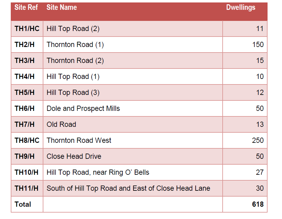
Proposed site TH1/HC

This area received planning permission for 11 dwellings, dated 13/7/17. The area originally formed the most northern part of a larger housing area, reference TH/002 Close Head. Land to the west of Thornton Cemetery in the former proposed Bradford Development Plan. The larger area, from Thornton Road near the bus turning circle to the dwellings at Close Head Lane, plus the TH1/HC site received planning permission in 2008, but hasn’t proceeded because of access issues at the Thornton Road end. The land, TH1/HC is owned by Bradford Council. (Updated 13 July 2025)
Proposed site TH2/H
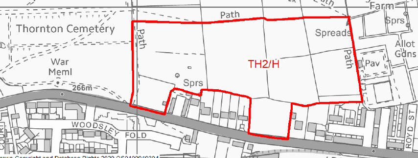
In the former Bradford Development Plan this was part of that plan TH003, though it no longer extends northward on the Cemetery side side to meet a site off Hill Top Road. The site, TH2/H, is owned by Bradford Council. (Updated 13 July 2025)
Proposed site TH3/H

The unkempt land between Foster Avenue and lower Coach Lane. Privately owned site. (Updated 13 July 2025)
Proposed site TH4/H
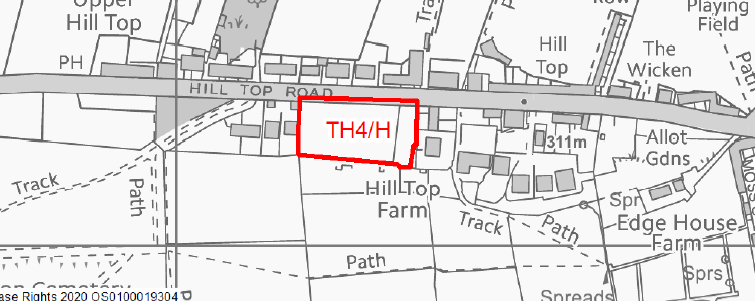
This is a field backing on to Thompson Square to the east, and extending to newish houses, to the west, on the south side of Hill Top Road. (Updated 13 July 2025)
Proposed site TH5/H

This land was bought from the original Abe Shaw, by Bradford Council for allotments. The land has many springs in it. Edge House Farm, in the centre of the site has recently received planning approval to be extended, with another floor. (Updated 13 July 2025)
Proposed site TH6/H

The site of Dole and Prospect textile mills. Privately owned. (Updated 13 July 2025)
Proposed site TH7/H
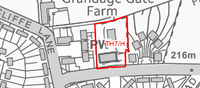
A Planning application, 23/02144/MAR, was submitted in August 2023 for 16 dwellings on this site, and aspects of the detail are still being considered. The principle of housing on this site has been agreed. (Updated 13 July 2025)
Proposed site TH8/HC

This site received planning permission for up to 250 dwellings on 21/8/2019, but the detailed application, which was approved on 4 June 2021, is only for 160 dwellings. The majority of the houses now built. A site plan showing layout and the names of the roads is given below. Note that it has since been recognised by the builders that Bramwell Brontë Close should be Branwell Brontë Close (n not m, in Branwell). There are no dwellings directly under electricity cables between pylons. (Updated 13 July 2025)

Proposed site TH9/H

Land above Close Head Drive and Ash Tree Avenue. Believed to be privately owned, (Updated 13 July 2025)
Proposed site TH10/H
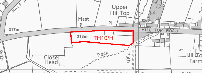
Land at the top of the cemetery opposite the Ring o’ Bells, some of it used as a car park for that pub. (Updated 13 July 2025)
Proposed site TH11/H
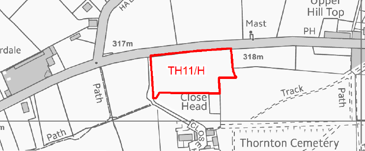
This site is owned by Bradford Council, and is immediately north of proposed site TH1/HC, for which they obtained planning permission in 2016 for 16 dwellings. While the permission has lapsed for TH1/HC, the principle of building dwellings there (TH1/HC), has been established. (Updated 13 July 2025)
The consultation asks the following Questions:


(Updated 13 July 2025)
